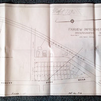
Map 713 - Fairview Development plan 1910
Item
Description
This map shows the right of way obtained in 1872 by the Water Comissioners of Poughkeepsie to install a line across the property to reach a resevoir, and the railroad sector obtained by the Poughkeepsie and Eastern RR. The water line ran up the water works road dividing the Marist property, a stub of this road shows near the word "Post" below Albany Post Road.
Creator
Print of this map #713 sold by Dutchess County Clerk's office 24 September 2013.
Type
Map