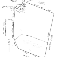
Map of Marist Brothers' parcel
Item
Description
THIS INDENTURE made this 1st day of August, 1942.
BETWEEN NEW YORK PROTESTANT EPISCOPAL CITY MISSION SOCIETY, a religious corporation duly incorporated by Chapter 121 of the Laws of 1833 passed April 9, 1833 as last amended by Chapter 86 of the Laws of 1934 passed March 22, 1934, having its principal office at No. 38 Bleecker Street in the Borough of Manhattan, City of New York, party of the first part, and
THE MARIST BROTHERS, a religious corporation organized and existing under the Laws of the State of New York, having its principal office at St. Ann’s Hermitage, Poughkeepsie, New York, party of the second part.
WHEREAS by petition verified the 11th day of July, 1942, application was made by the party of the first part on the 24th day of July 1942 before Mr. Justice Pierce H. Russell at a Special Term of the Supreme Court of the State of New York held in and for the County of Albany at the County Courthouse at Albany, New York, for leave to sell and convey to the party of the second part the fee of the premises hereinafter described; and
WHEREAS by an order dated the 24th of July, 1942, made by Mr. Justice Russell and duly entered in the office of the Clerk of the County of Ulster, the application of the party of the first part was granted and the party of the first part was authorized to sell and convey and deliver a good and sufficient deed of the premises hereinafter described to the Marist Brothers in consideration of the sum of Fifty thousand ($50,000) dollars;
NOW, THEREFORE, THIS INDENTURE WITNESSETH, that the party of the first part for the consideration above mentioned does hereby convey, release, grant, bargain and sell to the party of the second part, its successors and assigns forever, the following described premises:
ALL THAT CERTAIN PIECE OR PARCEL OF LAND situate in the Town of Esopus, County of Ulster, and State of New York, which by survey of Frank S. Hopkins, C. E., July, 1942, is bounded and described as follows:
BEGINNING at a concrete monument set in the assumed easterly line of the Highland-Kingston state road, known as Route 9W, and in the southerly line of lands of Beatty, and running thence along the wall, the line of said lands, S 74° 17' 10" E 143.60 feet; S 6° 37' 10" W 4.51 feet; S 75° 58' 40" E 166.59 feet; S 75° 16' 10" E 155.22 feet; N 3° 02' 50" W 86.15 feet; N 15° 43 '30" E 85.79 feet; N 35° 40' 20" E 45.98 feet; N 25° 54' 00" E 98.71 feet; N 16° 07' 30' E 51.95 feet; N 12° 45' 50" E 86.59 feet; N 14° 54' 20" E 43.42 feet; and N 20° 14' 20" E 95.92 feet to a corner in said wall; thence still along said wall, the line of said Beatty lands, S 70° 26' 10" E 175.58 feet, S 69° 13' 50" E 274.30 feet; S 67° 53' 50" E 829.60 feet; S 68° 24' 20" E 342.34 feet; and S 68° 28' 10" E 751 feet more or less to the high water line of the Hudson River; thence southerly along the same to a point in the northerly line of lands of Dr. R. E. Gordon, said point being distant S 12° 37' 10" W 3402 feet more or less from the northeasterly corner of the hereindescribed premises; thence along the wall, the line of said Gordon lands, N 66° 22' 50" W 574 feet more or less; N 68° 06' 50" W 307.07 feet; and N 66° 54' 40" W 1179.45 feet to a point in the assumed easterly line of the above-mentioned state road; thence along the same N 20° 55' 20" W 782.17 feet along a wall to a concrete monument; N 10° 52' 10" W 265.55 feet to another concrete monument; thence along the wall the following courses and distances: N 3° 15' 10" E 585.45 feet; N 2° 01' 40" E 372.32 feet; N 1° 49' 10" E 184.67 feet; N 7° 42' 40" E 647.56 feet; N 0° 48' 40" E 56.47 feet; N 17° 53' 40" W 26.88 feet; and N 8° 06' 10" 89.67 feet to the point or place of beginning, containing 200.20 acres.
TOGETHER with all the riparian rights and land under water appurtenant to the said premises, and also all the right, title and interest of the party of the first part under Chapter 349 of the Laws of 1845 entitled "An Act to authorize Archibald Russell to erect a dock or wharf in the Hudson River, in the Town of Esopus, adjoining his lands" passed May 14, 1845
TOGETHER with all the right, title and interest of the part of the first part in and to the bed of state highway 9W in front of said premises to the center line thereof, and all farm equipment belonging to the party of the first part now on said premises and all the personal property belonging to the party of the first part now in the Payne Mansion.
BEING part of the premises conveyed to the party of the first part by Harry Payne Bingham and Grace M. Bingham, his wife, by deed dated the 6th day of April, 1933 and recorded in the office of the Clerk of the county of Ulster on the 20th day of April, 1933 in Liber 564 of Deeds, at page 340.
TO HAVE AND TO HOLD said premises with the appurtenances unto the said party of the second part, its successors and assigns forever.
AND the party of the first part, in compliance with Section 13 of the Lien Law, hereby covenants that the party of the first part will receive the consideration for this conveyance as a trust fund to be applied first for the purpose of paying the cost of the improvement and will apply the same first to the payment of the cost of the improvement before using any part of the total of the same for any other purpose.
IN WITNESS WHEREOF the party of the first part has caused these presents to be signed by its President and its corporate seal to be hereunto affixed the day and year first above written.
(corp. seal) NEW YORK PROTESTANT EPISCOPAL CITY MISSION SOCIETY
By William T. Manning
President
$55.00 I.R. Stamps cancelled
STATE OF NEW YORK
COUNTY OF NEW YORK SS.:
On this first day of August, 1942, before me personally came WILLIAM T. MANNING to me known, who being by me duly sworn did depose and say that he resides at Cathedral Close, Cathedral Heights in the Borough of Manhattan, City of New York; that he is President of NEW YORK PROTESTANT EPISCOPAL CITY MISSION SOCIETY the corporation described in and which executed the foregoing instrument; that he knows the seal of said corporation; that the seal affixed to said instrument is such corporate seal; that it was so affixed by order of the Board of Managers of said corporation and that he signed his name thereto by like order
(seal) Ada M. Barr
Notary Public, New York County
Certificate filed in N.Y. Co. Clerk's No. 32
N.Y. Co. Registers No. 4839
Commission Expires March 30, 1944
STATE OF NEW YORK
COUNTY OF NEW YORK SS.: No. 19899
I, ARCHIBALD R. WATSON, County Clerk and Clerk of the Supreme Court, New York County, the same being a Court of Record having by law a seal, DO HEREBY CERTIFY, that ADA M. BARR whose name is subscribed to the annexed deposition, certificate of acknowledgment or proof, was at the time of taking the same a NOTARY PUBLIC in and for said County, duly commissioned and sworn and qualified to act as such and authorized by the laws of the State of New York to protest notes, to take and certify depositions, to administer oaths and affirmations and certify the acknowledgment of proof of deeds and other written instruments for lands, tenements and hereditaments, to be read in evidence or recorded in this State. And further, that I am well acquainted with the handwriting of such Notary Public, or have compared the signature of such office with his autograph signature filed in my office, and believe that the signature to the said annexed instrument is genuine.
IN WITNESS WHEREOF, I have hereunto set my hand and affixed the seal of the said "Court and County this 3 day of Aug., 1942.
(seal) Archibald R. Watson
County Clerk and Clerk of the
Supreme Court, New York County
A true record entered
Aug. 21, 1942 at 9 A.M.
this is a transcription of a deed located in the Ulster County Clerk's Vault Room, Kingston, New York
Type
Map