Employee Cottages / McLaren / Lafko
Item
Description
This Indenture Made the 22nd day of September Nineteen Hundred and Seventy-seven between FRED LAFKO, of New Hackensack Road, Wappingers Falls, Dutchess County, New York, WILLIAM A. KELLY , of 165 Pearl Street, Kingston, Ulster County, New York and PAMELA LEVINE, of Red Hook, Dutchess County, New York, parties or the first part, and FRED LAFKO, of New Hackensack Road, Wappingers Falls, Dutchess County, New York, party or the second part
Witnesseth that the parties or the first part in consideration of ONE Dollar ($1.00 ) lawful money of the United States , paid by the party of the second part, do hereby remise, release and quitclaim unto the party of the second part, his distributees and assigns forever,
ALL THAT TRACT, PIECE OR PARCEL OF LAND with the improvements thereon situate in the Town of Esopus, County of Ulster and State of New York, more particularly bounded and described as follows:
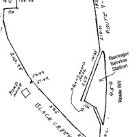
COMMENCING at a point on the westerly side of the state highway leading from Highland to Kingston known as Route 9W, said point being at a stone wall in the bounds of the premises conveyed to the party of the second part by a deed from Walrus, Inc. dated September 11, 1968 and recorded in the Ulster County Clerk's Office on September 25, 1968 in Liber 1218 of Deeds at page 485; thence running along the center line of said stone wall South 35° 44' 30" West 101.35 feet and South 33 ° 32' 20" West 253.79 feet to the center line of the former road connecting Route 9W with the Old Post Road and now said to be abandoned; running thence along the center line of said road, now said to be abandoned, South 48° 17'40" East 100 feet and South 10° 31' 20" East 105.57 feet to the westerly side of said state highway leading from Highland to Kingston known as Route 9W thence running along the westerly side of said highway in a northerly direction 450 feet more or less to the point and place of beginning. BEING the same premises as described In a certain conveyance from Lewis F . McLaren to the parties of the first part herein, dated the 3rd day of June, 1970 and recorded in the office of the Clerk of Ulster County, in Liber 1245 of Deeds at page 1030.
To have and to hold the premises herein granted unto the party of the second part, his distributees and assigns forever
In Witness Whereof, the parties of the first part have hereunto set their hands and seals the day and year first above written.
signed Fred Lafko
signed Linda Levine
signed William A Kelly
State of New York
County of Dutchess ss.:
On this 10th day of May 1979 before me, the subscriber, personally appeared Fred Lafko and Pamela Levine to me personally known and known to me to be the same persons described in and who executed the within Instrument and they acknowledged to me that they executed the same.
William S. Bain
Notary Public
State of New York
County of Ulster
On this 22nd day of September Nineteen Hundred and Seventy seven before me, the subscriber, personally appeared William A Kelly to me personally known and known to me to be the same person described in and who executed the within Instrument and he acknowledged to me that they executed the same
Charles J. Saccoman
Notary Public
Filed 12:45 pm on May 10, 1979 by Albert Spada, Ulster County Clerk
This deed located in the Ulster County Clerk's Vault Room, Kingston, New York was transcribed to the web site on Monday, 28 January 2002.
This Indenture, made the 10 day of December, nineteen hundred and seventy-six between Black Creek Realty, Inc., a corporation having its principal place of business at Wappingers Falls, Duchess County, NEw York, party of the first part, and Fred J. Lafko, Box 359 New Hackensack Road, Wappingers Falls, New York, party of the second part,
Witnesseth, that the party of the first part, in consideration of One Dollar and other good and valuable consideration ($.100) dollars, lawful money of the United States, paid by the party of the second part, does hereby grant and release unto the party of the second part the heirs or successors and assigns of the party of the second part forever,
All that certain plot, piece or parcel of land, with the buildings and improvements thereon erected, situate, lying and being in the Town of Esopus, County of Ulster and State of New York, bounded and described as follows:
BEGINNING at a point, said point being Where the center line of Old Post Road intersects the right of way line of Route 9-W leading from Highland to Kingston, and running thence through the center line of said Old Post Road the following courses and distances: north thirty-two degrees nine minutes no seconds west two hundred thirty-four and fifty-seven one hundredths feet; thence north twenty-eight degrees twenty-five minutes no seconds west three hundred thirty-five and no one-hundredths feet; thence north twenty-five degrees thirty-four minutes thirty seconds west fifty and three one-hundredths feet; thence north nineteen degrees eleven minutes twenty seconds west fifty-one and seventy-two one hundredths feet; thence north fourteen degrees fifty-eight minutes ten seconds west fifty-four and eighty-nine one-hundredths feet; thence continuing along the center line of said Old Post Road north thirteen degrees twenty-four minutes thirty seconds west two hundred and forty and ninety-eight one-hundredths feet; north one degree sixteen minutes forty seconds east one hundred and eleven and forty- seven one hundredths feet and north twenty-one degrees forty-four minutes twenty seconds east seventy-three and twenty-five one-hundredths feet to a stone wall and the southwest corner of a cemetery thence running along the southerly line of said cemetery and the center line of said stone wall, south eighty-two degrees fifty-six minutes fifty seconds east ninety feet to the southeast corner of said cemetery and another stone wall, and thence running along the easterly line of said cemetery and the center line of said stone wall north nine degree eleven minutes thirty seconds east one hundred and eighteen and thirty eight one-hundredths feet to the southerly line of land now or formerly of James and a stone wall; thence running along the southerly line of said last mentioned land and part of the way along the center line of said stone wall, south seventy-three degrees twenty-seven minutes twenty seconds east eighty-one and seventy-two one-hundredths feet and south seventy-seven degrees twenty-seven minutes ten seconds east four hundred and seven and seventy -three one hundredths feet to the westerly side of said highway leading from Highland to Kingston, known as Route 9-W; thence running along the westerly side of said State Highway leading from Highland to Kingston known as Route 9-W south six degrees thirty-one minutes ten seconds west one hundred and seventy-two feet and south fifteen degrees fifty-seven minutes thirty seconds west two hundred and eighteen and seven one-hundredths feet to a corner of land formerly of Pell, now or formerly of Beatty and occupied by Barringer Service Station, at a stone wall; thence running along the westerly line of said last mentioned land and along the center line of said stone wall, south thirty-five degrees forty four minutes thirty seconds west one hundred and one and thirty-five one-hundredths feet and south thirty-three degrees thirty-two minutes twenty seconds west two hundred and fifty-three and seventy-nine one-hundredths feet to the center line of the former road connecting Route 9-W with the Old Post Road, and now said to be abandoned; thence running along the center line of said road now said to be abandoned and still along said land formerly of Pell, now or formerly of Beatty south forty-eight degrees seventeen minutes forty seconds east one hundred feet and south ten degrees thirty-one minutes twenty seconds east one hundred and five and fifty-seven one-hundredths feet to the westerly side of said State Highway leading from Highland to Kingston, known as Route 9-W; thence running along the westerly side of said State Highway, known as Route 9-W, the following courses and distances: south ten degrees seven minutes thirty seconds west two hundred and six and sixty-six one-hundredths feet to the center line of the Old Post Road, the point or place of beginning.
(Now or formerly of Walrus, Inc. and the parties of the first part)
TOGETHER with a reservoir or pump house located on other lands of the parties of the first part on the westerly side of Old Route 9-W and a strip of land fifty (50) feet wide extending twenty-five (25) feet on each side of the pipe leading from said pump house to Old Route 9-W and including the lands around said pimp house within a distance of ten (10) feet from the outside walls of the pump house, and the right to use such water as may be necessary for school purposes from the stream supplying said pump house.
BEING the same premises as conveyed by Lewis F. McLaren to Eugene J. Conley, G. Gibbs Peterson and William A. Kelly, by deed dated the 26th day of September, 1969 and recorded in the Office of the Clerk of Ulster County in Liber 1240 of Deeds at page 910.
SUBJECT to a certain bond and mortgage given by Lewis F. MC Laren to Walrus, Inc., dated the 11th day of September, 1968, and recorded in the Office of the Clerk of Ulster County in Liber 992 of Mortgages at page 964, and the parties of the second part hereby agree to and do hereby assume to pay said mortgage.
This instrument is intended to convey the above described premises as more accurately set forth in a certain survey made by Roy H. Pauli, dated the 8th day of August, 1972.
This deed has been executed by the grantor in accordance with the resolution authorizing same by the Board of Directors of the grantor and pursuant to the consent of all of the stockholders of record of the grantor consenting thereto.
Together with all right, title and interest, if any, of the party of the first part in and to any streets and roads abutting the above described premises to the center lines thereof,
Together with the appurtenances and all the estate and rights of the party of the first part in and to said premises,
To have and to hold the premises herein granted unto the party of the second part, the heirs or successors and assigns of the party of the second part forever.
And the party of the first part covenants that the party of the first part has not done or suffered anything whereby the said premises have bee incumbered in any way whatever, except as aforesaid.
lAnd the party of the first part, in compliance with Section 13 of the Lien Law, the grantor will receive the consideration for this conveyance and will hold the right to receive such consideration as a trust fund to be applied first for the purpose of paying the cost of the improvement and will apply the same first to the payment of the cost of the improvements before using any part of the total of the same for any other purpose.
The word "party" shall be construed as if it read "parties" whenever the sense of this indenture so requires.
In witness whereof, the party of the first part has duly executed this deed the day and year first above written.
In presence of: Black Creek Realty, Inc.
by Fred J. Lafko, President
State of New York }
County of Duchess } ss:
On the 10th day of December 1976 before me personally came Fred K. Lafko to me known who, being by me duly sworn, did depose and say that he resides at No. 359 New Hackensack Road, Wappingers Falls, New York that his is the President of Black Creek Realty, Inc., the corporation described in, and which executed the above Instrument; that he knows the seal of said corporation; that the seal affixed to said Instrument is such corporate seal, that it was so affixed by order of the Board of Directors of said corporation; that he signed his name thereto by like order.
Marvin Escher
Notary Public
Qualified in Nassau County
Filed 29 December 1976
Albert Spada
Ulster County Clerk
This deed located in the Ulster County Clerk's Vault Room was transcribed to the web site on 21 March 2002
Seventy-three between Eugene J. Conley, residing at 700 Duke Street, Alexandria, Virginia, party of the first part, and Black Creek Realty, Inc., a Domestic Corporation, organized and existing under the laws of the State of New York, having its principal place of business at Wappingers Falls, Dutchess County, New York, party of the second part
Witnesseth, that the party of the first part, in consideration of One Dollar ($.100) lawful money of the United States, paid by the party of the second part, do hereby grant and release unto the party of the second part, and assigns forever, all his right, title and interest in and to all
THAT PLOT OF LAND with the buildings thereon situate in the
Town of Esopus, County of Ulster and State of New York, bounded and described as follows:
BEGINNING at a point, said point being Where the center line of Old Post Road intersects the right of way line of Route 9-W leading from Highland to Kingston, and running thence through the center line of said Old Post Road the following courses and distances: north thirty-two degrees nine minutes no seconds west two hundred thirty-four and fifty-seven one hundredths feet; thence north twenty-eight degrees twenty-five minutes no seconds west three hundred thirty-five and no one-hundredths feet; thence north twenty-five degrees thirty-four minutes thirty seconds west fifty and three one-hundredths feet; thence north nineteen degrees eleven minutes twenty seconds west fifty-one and seventy-two one hundredths feet; thence north fourteen degrees fifty-eight minutes ten seconds west fifty-four and eighty-nine one-hundredths feet; thence continuing along the center line of said Old Post Road north thirteen degrees twenty-four minutes thirty seconds west two hundred and forty and ninety-eight one-hundredths feet; north one degree sixteen minutes forty seconds east one hundred and eleven and forty- seven one hundredths feet and north twenty-one degrees forty-four minutes twenty seconds east seventy-three and twenty-five one-hundredths feet to a stone wall and the southwest corner of a cemetery thence running along the southerly line of said cemetery and the center line of said stone wall, south eighty-two degrees fifty-six minutes fifty seconds east ninety feet to the southeast corner of said cemetery and another stone wall, and thence running along the easterly line of said cemetery and the center line of said stone wall north nine degree eleven minutes thirty seconds east one hundred and eighteen and thirty eight one-hundredths feet to the southerly line of land now or formerly of James and a stone wall; thence running along the southerly line of said last mentioned land and part of the way along the center line of said stone wall, south seventy-three degrees twenty-seven minutes twenty seconds east eighty-one and seventy-two one-hundredths feet and south seventy-seven degrees twenty-seven minutes ten seconds east four hundred and seven and seventy -three one hundredths feet to the westerly side of said highway leading from Highland to Kingston, known as Route 9-W; thence running along the westerly side of said State Highway leading from Highland to Kingston known as Route 9-W south six degrees thirty-one minutes ten seconds west one hundred and seventy-two feet and south fifteen degrees fifty-seven minutes thirty seconds west two hundred and eighteen and seven one-hundredths feet to a corner of land formerly of Pell, now or formerly of Beatty and occupied by Barringer Service Station, at a stone wall; thence running along the westerly line of said last mentioned land and along the center line of said stone wall, south thirty-five degrees forty four minutes thirty seconds west one hundred and one and thirty-five one-hundredths feet and south thirty-three degrees thirty-two minutes twenty seconds west two hundred and fifty-three and seventy-nine one-hundredths feet to the center line of the former road connecting Route 9-W with the Old Post Road, and now said to be abandoned; thence running along the center line of said road now said to be abandoned and still along said land formerly of Pell, now or formerly of Beatty south forty-eight degrees seventeen minutes forty seconds east one hundred feet and south ten degrees thirty-one minutes twenty seconds east one hundred and five and fifty-seven one-hundredths feet to the westerly side of said State Highway leading from Highland to Kingston, known as Route 9-W; thence running along the westerly side of said State Highway, known as Route 9-W, the following courses and distances: south ten degrees seven minutes thirty seconds west two hundred and six and sixty-six one-hundredths feet to the center line of the Old Post Road, the point or place of beginning.
(Now or formerly of Walrus, Inc. and the parties of the first part)
TOGETHER with a reservoir or pump house located on other lands of the parties of the first part on the westerly side of Old Route 9-W and a strip of land fifty (50) feet wide extending twenty-five (25) feet on each side of the pipe leading from said pump house to Old Route 9-W and including the lands around said pimp house within a distance of ten (10) feet from the outside walls of the pump house, and the right to use such water as may be necessary for school purposes from the stream supplying said pump house.
BEING the same premises as conveyed by Lewis F. McLaren to Eugene J. Conley, G. Gibbs Peterson and William A. Kelly, by deed dated the 26th day of September, 1969 and recorded in the Office of the Clerk of Ulster County in Liber 1240 of Deeds at page 910.
SUBJECT to a certain bond and mortgage given by Lewis F. MC Laren to Walrus, Inc., dated the 11th day of September, 1968, and recorded in the Office of the Clerk of Ulster County in Liber 992 of Mortgages at page 964, and the parties of the second part hereby agree to and do hereby assume to pay said mortgage.
This instrument is intended to convey the above described premises as more accurately set forth in a certain survey made by Roy H. Pauli, dated the 8th day of August, 1972.
Together with the appurtenances and all the estate and rights of the party of the first part in and to said premises.
To have and to hold the premises herein granted unto the partiy of the second part and assigns forever.
And said party of the first part covenants as follows:
First, That the party of the second part shall quietly enjoy the said premises;
Second, That said party of the first part will forever Warrant the title to said premises.
Third, That in compliance with Section 13 of the Lien Law, the grantor will receive the consideration for this conveyance and will hold the right to receive such consideration as a trust fund to be applied first for the purpose of paying the cost of the improvement and will apply the same first to the payment of the cost of the improvements before using any part of the total of the same for any other purpose.
In Witness Whereof, the party of the first part has hereunto set his hand and seal the day and year first above written.
Eugene J. Conley (seal)
Black Creek Realty Inc
by Fred J. Lafko, President
State of Virginia }
City of Alexandfria } ss,:
On this 17th day of April Nineteen Hundred and Seventy-three before me, the subscriber, personally appeared Eugene J. Conley to me personally known and known to me to be the same person described in and who executed the within Instrument and he acknowledged to me that he executed the same
Harvey Boltwood
Notary Public
State of New York }
County of Dutchess } ss,:
On this 11th day of April Nineteen Hundred and Seventy-three before me, the subscriber, personally came Fred K. Lafko to me personally known who, being by me duly sworn, did depose and say that he resided in Wappingers Falls, New York that his is the President of Black Creek Realty the corporation described in, and which executed the above Instrument; that he knows the seal of said corporation; that the seal affixed to said Instrument is such corporate seal, that it was so affixed by order of the Board of Directors of said corporation; that he signed his name thereto by like order.
Thomas D. Mahar, Jr.
Notary Public
Qualified in Dutchess County
Filed 2 April 1973
Albert Spada
Ulster County Clerk
This deed located in the Ulster County Clerk's Vault Room, Kingston, New York was transcribed to the web site 21 March 2002
Seventy-three between G. Gibbs Peterson, residing at Lewisbury, Pennsylvania, party of the first part, and Black Creek Realty, Inc., a Domestic Corporation, organized and existing under the laws of the State of New York, having its principal place of business at Wappingers Falls, Dutchess County, New York, party of the second part
Witnesseth, that the party of the first part, in consideration of One Dollar ($.100) lawful money of the United States, paid by the party of the second part, do hereby grant and release unto the party of the second part, and assigns forever, all his right, title and interest in and to all
THAT PLOT OF LAND with the buildings thereon situate in the
Town of Esopus, County of Ulster and State of New York, bounded and described as follows:
BEGINNING at a point, said point being Where the center line of Old Post Road intersects the right of way line of Route 9-W leading from Highland to Kingston, and running thence through the center line of said Old Post Road the following courses and distances: north thirty-two degrees nine minutes no seconds west two hundred thirty-four and fifty-seven one hundredths feet; thence north twenty-eight degrees twenty-five minutes no seconds west three hundred thirty-five and no one-hundredths feet; thence north twenty-five degrees thirty-four minutes thirty seconds west fifty and three one-hundredths feet; thence north nineteen degrees eleven minutes twenty seconds west fifty-one and seventy-two one hundredths feet; thence north fourteen degrees fifty-eight minutes ten seconds west fifty-four and eighty-nine one-hundredths feet; thence continuing along the center line of said Old Post Road north thirteen degrees twenty-four minutes thirty seconds west two hundred and forty and ninety-eight one-hundredths feet; north one degree sixteen minutes forty seconds east one hundred and eleven and forty- seven one hundredths feet and north twenty-one degrees forty-four minutes twenty seconds east seventy-three and twenty-five one-hundredths feet to a stone wall and the southwest corner of a cemetery thence running along the southerly line of said cemetery and the center line of said stone wall, south eighty-two degrees fifty-six minutes fifty seconds east ninety feet to the southeast corner of said cemetery and another stone wall, and thence running along the easterly line of said cemetery and the center line of said stone wall north nine degree eleven minutes thirty seconds east one hundred and eighteen and thirty eight one-hundredths feet to the southerly line of land now or formerly of James and a stone wall; thence running along the southerly line of said last mentioned land and part of the way along the center line of said stone wall, south seventy-three degrees twenty-seven minutes twenty seconds east eighty-one and seventy-two one-hundredths feet and south seventy-seven degrees twenty-seven minutes ten seconds east four hundred and seven and seventy -three one hundredths feet to the westerly side of said highway leading from Highland to Kingston, known as Route 9-W; thence running along the westerly side of said State Highway leading from Highland to Kingston known as Route 9-W south six degrees thirty-one minutes ten seconds west one hundred and seventy-two feet and south fifteen degrees fifty-seven minutes thirty seconds west two hundred and eighteen and seven one-hundredths feet to a corner of land formerly of Pell, now or formerly of Beatty and occupied by Barringer Service Station, at a stone wall; thence running along the westerly line of said last mentioned land and along the center line of said stone wall, south thirty-five degrees forty four minutes thirty seconds west one hundred and one and thirty-five one-hundredths feet and south thirty-three degrees thirty-two minutes twenty seconds west two hundred and fifty-three and seventy-nine one-hundredths feet to the center line of the former road connecting Route 9-W with the Old Post Road, and now said to be abandoned; thence running along the center line of said road now said to be abandoned and still along said land formerly of Pell, now or formerly of Beatty south forty-eight degrees seventeen minutes forty seconds east one hundred feet and south ten degrees thirty-one minutes twenty seconds east one hundred and five and fifty-seven one-hundredths feet to the westerly side of said State Highway leading from Highland to Kingston, known as Route 9-W; thence running along the westerly side of said State Highway, known as Route 9-W, the following courses and distances: south ten degrees seven minutes thirty seconds west two hundred and six and sixty-six one-hundredths feet to the center line of the Old Post Road, the point or place of beginning.
(Now or formerly of Walrus, Inc. and the parties of the first part)
TOGETHER with a reservoir or pump house located on other lands of the parties of the first part on the westerly side of Old Route 9-W and a strip of land fifty (50) feet wide extending twenty-five (25) feet on each side of the pipe leading from said pump house to Old Route 9-W and including the lands around said pimp house within a distance of ten (10) feet from the outside walls of the pump house, and the right to use such water as may be necessary for school purposes from the stream supplying said pump house.
BEING the same premises as conveyed by Lewis F. McLaren to Eugene J. Conley, G. Gibbs Peterson and William A. Kelly, by deed dated the 26th day of September, 1969 and recorded in the Office of the Clerk of Ulster County in Liber 1240 of Deeds at page 910.
SUBJECT to a certain bond and mortgage given by Lewis F. MC Laren to Walrus, Inc., dated the 11th day of September, 1968, and recorded in the Office of the Clerk of Ulster County in Liber 992 of Mortgages at page 964, and the parties of the second part hereby agree to and do hereby assume to pay said mortgage.
This instrument is intended to convey the above described premises as more accurately set forth in a certain survey made by Roy H. Pauli, dated the 8th day of August, 1972.
Together with the appurtenances and all the estate and rights of the party of the first part in and to said premises.
To have and to hold the premises herein granted unto the partiy of the second part and assigns forever.
And said party of the first part covenants as follows:
First, That the party of the second part shall quietly enjoy the said premises;
Second, That said party of the first part will forever Warrant the title to said premises.
Third, That in compliance with Section 13 of the Lien Law, the grantor will receive the consideration for this conveyance and will hold the right to receive such consideration as a trust fund to be applied first for the purpose of paying the cost of the improvement and will apply the same first to the payment of the cost of the improvements before using any part of the total of the same for any other purpose.
In Witness Whereof, the party of the first part has hereunto set his hand and seal the day and year first above written.
G. Gibbs Peterson (seal)
Black Creek Realty Inc
by Fred J. Lafko, President
State of Pennsylvania }
County of Dauphin } ss,:
On this 18th day of April Nineteen Hundred and Seventy-three before me, the subscriber, personally appeared G. Gibbs Peterson to me personally known and known to me to be the same person described in and who executed the within Instrument and he acknowledged to me that he executed the same
Patricia M. Zugay
Notary Public
State of New York }
County of Dutchess } ss,:
On this 11th day of April Nineteen Hundred and Seventy-three before me, the subscriber, personally came Fred K. Lafko to me personally known who, being by me duly sworn, did depose and say that he resided in Wappingers Falls, New York that his is the President of Black Creek Realty the corporation described in, and which executed the above Instrument; that he knows the seal of said corporation; that the seal affixed to said Instrument is such corporate seal, that it was so affixed by order of the Board of Directors of said corporation; that he signed his name thereto by like order.
Thomas D. Mahar, Jr.
Notary Public
Qualified in Dutchess County
Commonwealth of Pennsylvania
Dauphin County, ss:
I, Lester A. Sheaffer, Protonotary of the County of Dauphin in he Commonwealth of Pennsylvania, and also Protonotary of the Court of Common Pleas, the same being a Court of Record of the aforesaid County, having by law a seal, do hereby certify that Patricia M. Zugay by whom the foregoing Acknowledgment was taken and whose name is subscribed thereto, was at the time of taking the same Notary Public residing in said County, duly commissioned and sworn and authorized by the laws of said Commonwealth to take the proof or acknowledgment of deeds and other instruments in writing to be recorded in said Commonwealth, and to administer oaths or affirmations in said County, and that I am well acquainted with her handwriting and verily believe that the signature to the forgoing certificate is genuine.
In Witness whereof, I have hereunto set my hand and affixed my official seal, which is the seal of said Court this 18th day of April 1973
Lester A. Sheaffer
Protonotary
Filed 27April 1973
Albert Spada
Ulster County Clerk
This Indenture, Made the 20th day of December, Nineteen Hundred and Seventy-two Between William A. Kelly, residing at 165 Pearl Street, Kingston, New York, party of the first part, and Black Creek Realty, Inc., a Domestic Corporation, organized and existing under the laws of the State of New York, having its principal place of business at Wappingers Falls, Dutchess County, New York, party of the second part
Witnesseth, that the party of the first part, in consideration of One Dollar ($.100) lawful money of the United States, paid by the party of the second part, do hereby grant and release unto the party of the second part, and assigns forever, all his right, title and interest in and to all
THAT PLOT OF LAND with the buildings thereon situate in the
Town of Esopus, County of Ulster and State of New York, bounded and described as follows:
BEGINNING at a point, said point being Where the center line of Old Post Road intersects the right of way line of Route 9-W leading from Highland to Kingston, and running thence through the center line of said Old Post Road the following courses and distances: north thirty-two degrees nine minutes no seconds west two hundred thirty-four and fifty-seven one hundredths feet; thence north twenty-eight degrees twenty-five minutes no seconds west three hundred thirty-five and no one-hundredths feet; thence north twenty-five degrees thirty-four minutes thirty seconds west fifty and three one-hundredths feet; thence north nineteen degrees eleven minutes twenty seconds west fifty-one and seventy-two one hundredths feet; thence north fourteen degrees fifty-eight minutes ten seconds west fifty-four and eighty-nine one-hundredths feet; thence continuing along the center line of said Old Post Road north thirteen degrees twenty-four minutes thirty seconds west two hundred and forty and ninety-eight one-hundredths feet; north one degree sixteen minutes forty seconds east one hundred and eleven and forty- seven one hundredths feet and north twenty-one degrees forty-four minutes twenty seconds east seventy-three and twenty-five one-hundredths feet to a stone wall and the southwest corner of a cemetery thence running along the southerly line of said cemetery and the center line of said stone wall, south eighty-two degrees fifty-six minutes fifty seconds east ninety feet to the southeast corner of said cemetery and another stone wall, and thence running along the easterly line of said cemetery and the center line of said stone wall north nine degree eleven minutes thirty seconds east one hundred and eighteen and thirty eight one-hundredths feet to the southerly line of land now or formerly of James and a stone wall; thence running along the southerly line of said last mentioned land and part of the way along the center line of said stone wall, south seventy-three degrees twenty-seven minutes twenty seconds east eighty-one and seventy-two one-hundredths feet and south seventy-seven degrees twenty-seven minutes ten seconds east four hundred and seven and seventy -three one hundredths feet to the westerly side of said highway leading from Highland to Kingston, known as Route 9-W; thence running along the westerly side of said State Highway leading from Highland to Kingston known as Route 9-W south six degrees thirty-one minutes ten seconds west one hundred and seventy-two feet and south fifteen degrees fifty-seven minutes thirty seconds west two hundred and eighteen and seven one-hundredths feet to a corner of land formerly of Pell, now or formerly of Beatty and occupied by Barringer Service Station, at a stone wall; thence running along the westerly line of said last mentioned land and along the center line of said stone wall, south thirty-five degrees forty four minutes thirty seconds west one hundred and one and thirty-five one-hundredths feet and south thirty-three degrees thirty-two minutes twenty seconds west two hundred and fifty-three and seventy-nine one-hundredths feet to the center line of the former road connecting Route 9-W with the Old Post Road, and now said to be abandoned; thence running along the center line of said road now said to be abandoned and still along said land formerly of Pell, now or formerly of Beatty south forty-eight degrees seventeen minutes forty seconds east one hundred feet and south ten degrees thirty-one minutes twenty seconds east one hundred and five and fifty-seven one-hundredths feet to the westerly side of said State Highway leading from Highland to Kingston, known as Route 9-W; thence running along the westerly side of said State Highway, known as Route 9-W, the following courses and distances: south ten degrees seven minutes thirty seconds west two hundred and six and sixty-six one-hundredths feet to the center line of the Old Post Road, the point or place of beginning.
TOGETHER with a reservoir or pump house located on other lands of the parties of the first part on the westerly side of Old Route 9-W and a strip of land fifty (50) feet wide extending twenty-five (25) feet on each side of the pipe leading from said pump house to Old Route 9-W and including the lands around said pimp house within a distance of ten (10) feet from the outside walls of the pump house, and the right to use such water as may be necessary for school purposes from the stream supplying said pump house.
BEING the same premises as conveyed by Lewis F. McLaren to Eugene J. Conley, G. Gibbs Peterson and William A. Kelly, by deed dated the 26th day of September, 1969 and recorded in the Office of the Clerk of Ulster County in Liber 1240 of Deeds at page 910.
SUBJECT to a certain bond and mortgage given by Lewis F. MC Laren to Walrus, Inc., dated the 11th day of September, 1968, and recorded in the Office of the Clerk of Ulster County in Liber 992 of Mortgages at page 964, and the parties of the second part hereby agree to and do hereby assume to pay said mortgage.
This instrument is intended to convey the above described premises as more accurately set forth in a certain survey made by Roy H. Pauli, dated the 8th day of August, 1972.
Together with the appurtenances and all the estate and rights of the party of the first part in and to said premises.
To have and to hold the premises herein granted unto the partiy of the second part and assigns forever.
And said party of the first part covenants as follows:
First, That the party of the second part shall quietly enjoy the said premises;
Second, That said party of the first part will forever Warrant the title to said premises.
Third, That in compliance with Section 13 of the Lien Law, the grantor will receive the consideration for this conveyance and will hold the right to receive such consideration as a trust fund to be applied first for the purpose of paying the cost of the improvement and will apply the same first to the payment of the cost of the improvements before using any part of the total of the same for any other purpose.
In Witness Whereof, the party of the first part has hereunto set his hand and seal the day and year first above written.
William A. Kelly (seal)
Black Creek Realty Inc
by Fred J. Lafko, President
State of New York }
County of Ulster } ss,:
On this 26th day of December Nineteen Hundred and Seventy-two before me, the subscriber, personally appeared William A. Kelly to me personally known and known to me to be the same person described in and who executed the within Instrument and he acknowledged to me that he executed the same
Guido J. Napoletano
Notary Public
Resident in and for Ulster County
State of New York }
County of Ulster } ss,:
On this 20th day of December Nineteen Hundred and Seventy-two before me, the subscriber, personally came Fred K. Lafko to me personally known who, being by me duly sworn, did depose and say that he resided in Wappingers Falls, New York that his is the President of Black Creek Realty the corporation described in, and which executed the above Instrument; that he knows the seal of said corporation; that the seal affixed to said Instrument is such corporate seal, that it was so affixed by order of the Board of Directors of said corporation; that he signed his name thereto by like order.
William A. Kelly
Notary Public
Qualified in Ulster County
Filed 22 March 1973
Albert Spada
Ulster County Clerk
This Indenture made the 26th day of September Nineteen Hundred and Sixty-nine Between Lewis F. McLaren, residing at P. O. Box 218, Town of Esopus, Ulster County, New York, party of the first part, and Eugene J. Conley, residing at 700 Duke Street, Alexandria, Virginia, G. Gibbs Peterson, residing at R. D. 1, Lewisberry Pennsylvania 17339 and William A. Kelly, residing at 165 Pearl Street, Kingston, new York, 12401, as tenants in common, parties of the second part
Witnesseth that the party of the first part, in consideration of ONE Dollar ($ 1.00 ) lawful money of the United States, paid by the parties of the second part, do hereby grant and release unto the parties of the second part, their heirs, and assigns forever,
All THAT PLOT OF LAND with the buildings thereon situate in the Town of Esopus, County of Ulster and State of New York, bounded and described as follows:
BEGINNING at a point, said point being where the center line of Old Post Road intersects the right of way line of Route 9-W leading from Highland to Kingston, and running thence through the center line of said Old Post Road the following courses and distances: north thirty-two degrees nine minutes no seconds west two hundred thirty-four and fifty-seven one hundredths feet; thence north twenty-eight degrees twenty-five minutes no seconds west three hundred thirty-five and no one-hundredths feet; thence north twenty-five degrees thirty-four minutes thirty seconds west fifty and three one-hundredths feet; hence north nineteen degrees eleven minutes twenty seconds west fifty-one and seventy-two one-hundredths feet; thence north fourteen degrees fifty-eight minutes ten seconds west fifty-four and eighty-nine one-hundredths feet; thence continuing along the center line of said Old Post Road north thirteen degrees twenty-four minutes thirty seconds east two hundred and forty and ninety-eight one-hundredths feet; north one degree sixteen minutes forty seconds east one hundred and eleven and forty-seven one-hundredths feet and north twenty-one degrees forty-four minutes twenty seconds east seventy-three and twenty-five one-hundredths feet to a stone wall and the southwest corner of a cemetery hence running along the southerly line of said cemetery and the center line of said stone wall, south eighty-two degrees fifty-six minutes fifty seconds east ninety feet to the southeast corner of said cemetery and another stone wall, and thence running along the easterly line of said cemetery and the center line of said stone wall north nine degrees eleven minutes thirty seconds east one hundred and eighteen and thirty-eight one-hundredths feet to the southerly line of land now or formerly of James and a stone wall; thence running along the southerly line of said last mentioned land and part of the way along the center line of said stone wall, south seventy-three degrees twenty- even minutes twenty seconds east eighty-one and seventy-two one-hundredths feet and south seventy-seven degrees twenty-seven minutes ten seconds east four hundred and seven and seventy-three one hundredths feet to the westerly side of said highway leading from Highland to Kingston, known as Route 9-W; thence running along the westerly side of said State Highway leading from Highland to Kingston known as Route 9-W, south six degrees thirty-one minutes ten seconds west one hundred and seventy-two feet and south fifteen degrees fifty-seven minutes thirty seconds west two hundred and eighteen and seven one- hundredths feet to a corner of land formerly of Pell, now or formerly of Beatty and occupied by Barringer Service Station, at a stone wall; thence running along the westerly line of said last mentioned land and along the center line of said stone wall, south thirty-five degrees forty four minutes thirty seconds west one hundred and one and thirty five one-hundredths feet and south thirty-three degrees thirty-two minutes twenty seconds west two hundred and fifty-three and seventy- nine one-hundredths feet to the center line of the former road connecting Route 9-W with the Old Post Road, and now said to be abandoned; thence running along the center line of said road now said to be abandoned and still along said land formerly of Pell, now or formerly of Beatty south forty-eight degrees seventeen minutes forty seconds east one hundred feet and south ten degrees thirty-one minutes twenty seconds east one hundred and five and fifty-seven one-hundredths feet to the westerly side of said State Highway leading from Highland to Kingston, known as Route 9-W; thence running along the westerly side of said State Highway, known as Route 9-\v, the following courses and distances: south ten degrees seven minutes thirty seconds west two hundred and six and sixty-six one-hundredths feet to the center line of the Old Post Road, the point or place of beginning. place of beginning.
TOGETHER with a reservoir or pump house located on other lands of the parties of the first part on the westerly side of Old Route 9-W), and a strip of land fifty (50) feet wide extending twenty-five (25) on each side of the pipe leading from said pump house to Old Route 9-Wi and including the lands around said pump house within a distance of ten (10) feet from the outside walls of the pump house, and the right to use such water as may be necessary for school purposes from the stream supplying said pump house.
BEING the same premises as conveyed by Walrus, Inc. to Lewis F. McLaren by deed dated the 11th day of September, 1968 and recorded in the Ulster County Clerk's office September 25, 1968 in Liber 1218 of Deeds at page 485.
SUBJECT TO a certain bond and mortgage given to Walrus, Inc., by Grantor herein, subsequently assigned to Rudy Firmbach and which bond and mortgage the grantees herein assume to pay, which bond and mortgage was duly recorded in the Ulster County Clerk's office in Liber 392 of Mortgages at page 964.
Together with the appurtenances and all the estate and rights of the party of the first part in and to said premises
To have and to hold the premises herein granted unto the parties of the second part, their heirs and assigns forever
And said party of the first part covenant s as follows:
First. That the parties of the second part shall quietly enjoy the said premises
Second. That said party of the first part will forever war rant the totle to said premises
Third. That, in Compliance with Sec. 13 of the lien Law, the grantor will receive the consideration for this conveyance and will hold the right to receive such consideration as a trust fund to be applied first for the purpose of paying the cost of the improvement and will apply the same first to the payment of the cost of the improvement before using any part of the total of the same for any other purpose
In Witness Whereof, the party of the first part has hereunto set his hand and seal he say and year first above written.
signed Lewis F. McLaren
signed William a Kelly
signed Eugene J Conley
signed G. Gibbs Peterson
State of New York
County of Ulster SS.:
On this 26th day of September Nineteen Hundred and Sixty Nine before me, the subscriber, personally appeared Lewis F. McLaren to me personally known and known to me to be the same person described in and who executed the within Instrument, and he acknowledged to me that he executed the same.
Christy Guldy, Notary Public
State of New York
County of Ulster SS.:
On this 26th day of September Nineteen Hundred and Sixty Nine before me, the subscriber, personally appeared William A. Kelly to me personally known and known to me to be the same person described in and who executed the within Instrument, and he acknowledged to me that he executed the same.
Christy Guldy, Notary Public
State of Pennsylvania
City of Harrisburg, P.
On this the 16th day of October 1969, before me the subscriber, personally appeared, G. Gibbs Peterson, to me personally known and known to me to be the same person described in and who executed the within Instrument, and he acknowledged to me that he executed the same.
Jean R. Heisey, Notary Public
State of Virginia
City of Alexandria
On this the 16th day of October 1969, before me the subscriber, personally appeared, Eugene J. Conley, to me personally known and known to me to be the same person described in and who executed the within Instrument, and he acknowledged to me that he executed the same.
Marlene E. Davis, Notary Public
THIS INDENTURE, Made the 11th day of September, Nineteen Hundred and Sixty-eight, between WALRUS, INC., a New York Corporation organized under the laws of New York, with its principal place of business at 254 Fair Street, Kingston, Ulster County, New York, party of the first part, and LEWIS F. MC LAREN, residing at Town of Esopus, Ulster County, New York, P. O. Box 218, party of the second part,
WITNESSETH that the party of the first part, in consideration of TEN Dollars ($10.00) lawful money of the United States, and other good and valuable consideration paid by the party of the second part, does hereby grant and release unto the party of the second part and assigns forever,
ALL THAT PLOT OF LAND with the building thereon situate in the Town of Esopus, County of Ulster and State of New York, bounded and described as follows:
BEGINNING at a point, said point being where the center line of Old Post Road intersects the right of way line of Route 9-W leading from Highland to Kingston, and running thence through the center line of said Old Post Road the following courses and distances: north thirty-two degrees nine minutes no seconds west two hundred thirty-four and fifty-seven one hundredths feet; thence north twenty-eight degrees twenty-five minutes no seconds west three hundred thirty-five and no one-hundredths feet; thence north twenty-five degrees thirty-four minutes thirty seconds west fifty and three one-hundredths feet; thence north nineteen degrees eleven minutes twenty seconds west fifty one and seventy-two one hundredths feet; thence north fourteen degrees fifty-eight minutes ten seconds west fifty-four and eighty-nine one hundredths feet; thence continuing along the center line of said Old Post Road north thirteen degrees twenty-four minutes thirty seconds west two hundred and forty and ninety-eight one-hundredths feet; north one degree sixteen minutes forty seconds east one hundred and eleven and forty-seven one-hundredths feet and north twenty-one degrees forty four minutes twenty seconds east seventy-three and twenty-five one hundredths feet to a stone wall and the southwest corner of a cemetery thence running along the southerly line of said cemetery and the center line of said stone wall, south eighty-two degrees fifty-six minutes fifty seconds east ninety feet to the southeast corner of said cemetery and another stone wall, and thence running along the easterly line of said cemetery and the center line of said stone wall north nine degree eleven minutes thirty seconds east one hundred and eighteen and thirty-eight one-hundredths feet to the southerly line of the land now or formerly of James and a stone wall; thence running along the southerly line of said last mentioned land and part of the way along the center line of said stone wall, south seventy-three degrees twenty-seven minutes twenty seconds east eighty-one and seventy-two one-hundredths feet and south seventy-seven degrees twenty-seven minutes ten seconds east four hundred and seven and seventy-three one-hundredths feet to the westerly side of said highway leading from Highland to Kingston, known as Route 9-W; thence running along the westerly side of said State Highway leading from Highland to Kingston known as Route 9-W, south six degrees thirty-one minutes ten seconds west one hundred and seventy-two feet and south fifteen degrees fifty-seven minutes thirty seconds west two hundred and eighteen and sever one-hundredths feet. to a corner of land formerly of Pell, now or formerly of Beatty and occupied by Barringer Service Station, at a stone wall; thence running along the westerly line of said last mentioned land and along the center line of said stone wall, south thirty-five degrees forty-four minutes thirty second west one hundred-and one and thirty-five one-hundredths feet and south thirty-three degrees thirty-two minutes twenty seconds west two hundred and fifty-three and seventy-nine one-hundredths feet to the center line of the former road connecting Route 9-W with the Old Post Road, and now said to be abandoned; thence running along the center line of said road now said to be abandoned and still along said land formerly of Pell, now or formerly of Beatty south forty-eight degrees seventeen minutes forty seconds east one hundred feet and south ten degrees thirty-one minutes twenty seconds east one hundred and five and fifty-seven one-hundredths feet to the westerly side of said State Highway leading from Highland to Kingston, known as Route 9-W; thence running along the westerly side of said State Highway, known as Route 9-W, the following courses and distances: south ten degrees seven minutes thirty seconds west two hundred and six and sixty-six one-hundredths feet
to the center line of the Old Post Road, the point or place of beginning.
TOGETHER with a reservoir or pump house located on other lands of the parties of the first part on the westerly side of Old Route 9-W, and a strip of land fifty (50) feet wide extending twenty five (25) feet o9n each side of the pipe leading from said pump house to Old Route 9-W and including the lands around said pump house within a distance of ten (10) feet from the outside walls of the pump house, and the right to use such water as may be necessary for school purposes from the stream supplying said pump house.
BEING the same premises conveyed to Walrus, Inc., by Wiltwyck School for Boys, Inc. by deed dated May 2, 19676 and recorded in the Ulster County Clerk's Office in Liber 1196 of Deeds at page 983.
COVENANTED by the Grantor that road adjoining the above described premises on the south, known as Black Creek road, is a public highway.
TOGETHER with the appurtenances and all the estate and rights of the party of the first part in and to said premises.
TO HAVE AND TO HOLD the premises herein granted unto the party of the second part, and assigns forever.
IN WITNESS WHEREOF, the party of the first part has caused its corporate seal to be hereunto affixed, and these presents to be signed by its duly authorized officer this 11th day of September, Nineteen Hundred and Sixty-eight,
Walrus, Inc.
By Walter R. Seaman
STATE OF NEW YORK }
COUNTY OF ULSTER } SS.
On this 11th day of September, Nineteen Hundred and Sixty-eight before me personally came Walter R. Seaman to me personally known, who, being by me duly sworn, did depose and say that he resides in Town of Lloyd that he is the President of Walrus, Inc., the corporation described in, and which executed, the within instrument; that he knows the seal of said corporation; that the seal affixed to said instrument is such corporate seal; that it was so affixed by order of the Board of Directors of said corporation; and that he signed his name thereto by like order
George Rusk, Jr.
Notary Public, State of New York
Appointed in Ulster County
Commission Expires March 30, 1970
Filed 1:05 PM, Sep 25, 1968 Albert Spada, Ulster County Clerk
THIS INDENTURE, made the 2nd day of May, nineteen hundred and sixty-seven, between WILTWICK SCHOOL FOR BOYS, INC., a New York membership corporation having its principal office at 260 Park Avenue South, New York, N.Y., party of the first part, and WALRUS, INC., a New York corporation having its principal place of business at 254 Fair Street, Kingston, New York, party of the second part,
WITNESSETH, that the party of the first part, in consideration of Ten ($10.00) dollars, lawful money of the United States, paid by the party of the second part, does hereby grant and release unto the party of the second part, the heirs, or successors and assigns of the party of the second part forever,
ALL that certain plot, piece or parcel of land, with the buildings and improvements thereon erected, situate, lying and being in the Town of Esopus, County of Ulster and State of New York, more particularly described in Schedule A annexed hereto and hereby made a part hereof.
TOGETHER with the right of the Grantor, if any, to cross the right-of-way of the New York Central Railroad Company adjacent to a portion of the premises.
TOGETHER with all right, title and interest, if any, of the party of the first part in and to any streets and roads abutting the above described premises to the center lines thereof,
TOGETHER with the appurtenances and all the estate and rights of the party of the first part in and to said premises,
TO HAVE AND TO HOLD the premises herein granted unto the party of the second part, the heirs or successors and assigns of the party of the second part forever.
AND the party of the first part, in compliance with section 13 of the Lien Law, covenants that the party of the first part will receive the consideration for this conveyance and will hold the right to receive such consideration as a trust fund to be applied first for the purpose of paying the cost of the improvement and will apply the same first to the payment of the cost of the improvement before using any part of the total of the same for any other purpose.
The word "party" shall be construed as if it read "parties" whenever the sense of this indenture so requires.
IN WITNESS WHEREOF, the party of the first part has duly executed this deed the day and year first above written.
WILTWYCK SCHOOL FOR BOYS, INC.
By Carl M. Spero, Treasurer
STATE OF NEW YORK, COUNTY OF NEW YORK
On the 2nd day of May, 1967, before me personally came Carl M. Spero to me known, who, being by me duly sworn, did depose and say that he resides at No. 139 East 94th Street, New York, N.Y., that he is the Treasurer of Wiltwyck School for Boys, Inc., the corporation described in and which executed the foregoing instrument; that he knows the seal of said corporation; that the seal affixed to said instrument is such corporate seal; that it was so affixed by order of the board of directors of said corporation, and that he signed his name thereto by like order.
Joseph E. Browdy
No. 31-5468875
Notary Public, State of New York
Qualified in New York County
Commission Expires March 30, 1968
Filed 2:06 PM, May 17, 1967 Albert Spada, Ulster County Clerk
Schedule A
ALL THAT PLOT OF LAND with the buildings thereon situate in the Town of Esopus, County of Ulster and State of New York, bounded and described as follows:
BEGINNING at a point, said point being where the center line of Old Post Road intersects the right of way line of Route 9-W leading from Highland to Kingston, and running thence through the center line of said Old Post Road the following courses and distances: north thirty-two degrees nine minutes no seconds west two hundred thirty-four and fifty-seven one hundredths feet; thence north twenty-eight degrees twenty-five minutes no seconds west three hundred thirty-five and no one-hundredths feet; thence north twenty-five degrees thirty-four minutes thirty seconds west fifty and three one-hundredths feet; thence north nineteen degrees eleven minutes twenty seconds west fifty-one and seventy-two one-hundredths feet; thence north fourteen degrees fifty-eight minutes ten seconds west fifty-four and eighty-nine one-hundredths feet; thence continuing along the center line of said Old Post Road north thirteen degrees twenty-four minutes thirty seconds west two hundred and forty and ninety-eight one-hundredths feet; north one degree sixteen minutes forty seconds east one hundred and-eleven and forty-seven one-hundredths feet -and north twenty-one degrees forty-four minutes twenty seconds east seventy-three and twenty-five one-hundredths feet to a stone wall and the southwest corner a cemetery; thence running along the southerly line of said cemetery and the center line of said stone wall south eighty-two degrees fifty-six minutes fifty seconds east ninety feet to the southeast corner of said cemetery and another stone wall, and thence running along the easterly line of said cemetery and the center line of said stone well north nine degrees eleven minutes thirty seconds east one hundred and eighteen and thirty-eight one-hundredths feet to the southerly line of land now or formerly of James and a stone wall; thence; running along the southerly line of said last mentioned land and part of the way along the center line of said stone wall south seventy-three degrees twenty-seven minutes twenty seconds east eighty-one and seventy-two one-hundredths feet and south seventy-seven degrees twenty-seven minutes ten seconds east four hundred and seven and seventy-three one-hundredths feet to the westerly side of said highway lending from Highland to Kingston, known as Route 9-W; thence running along the westerly side of said State Highway leading from Highland to Kingston known as Route 9-W , south six degrees thirty-one minutes ten seconds west one hundred and seventy-two feet and south fifteen degrees fifty-seven minutes thirty seconds west two hundred and eighteen and seven one-hundredths. feet to a corner of land formerly of Pell, now or formerly of Beatty and occupied by Barringer Service Station, at stone wall; thence running along the westerly line of said last mentioned land and along tie center line of said stone wall south thirty-five degrees forty-four minutes thirty seconds west one hundred and one and thirty-five one-hundredths feet and south thirty-three degrees thirty- two minutes twenty seconds west two hundred and fifty-three and seventy-nine one-hundredths feet to the center line of the former. road connecting Route 9-W with the Old Post Road, and now said to be abandoned; thence running along the center line of said road now said to be abandoned arid still along said land formerly of Pell, now or formerly of Beatty south forty-eight degrees seventeen minutes forty seconds east one hundred feet and south ten degrees thirty-one minutes twenty seconds east one hundred and five and fifty-seven one-hundredths feet to the westerly side of said State Highway leading from Highland to Kingston, known as Route 9-W; thence running along the westerly side of said State Highway known as Route 9-W the following courses and distances: south ten degrees seven minutes thirty seconds west two hundred and six and sixty-six one-hundredths feet to the center line of the Old Post Rod,. the point or place of beginning.
Witnesseth that the parties or the first part in consideration of ONE Dollar ($1.00 ) lawful money of the United States , paid by the party of the second part, do hereby remise, release and quitclaim unto the party of the second part, his distributees and assigns forever,
ALL THAT TRACT, PIECE OR PARCEL OF LAND with the improvements thereon situate in the Town of Esopus, County of Ulster and State of New York, more particularly bounded and described as follows:
COMMENCING at a point on the westerly side of the state highway leading from Highland to Kingston known as Route 9W, said point being at a stone wall in the bounds of the premises conveyed to the party of the second part by a deed from Walrus, Inc. dated September 11, 1968 and recorded in the Ulster County Clerk's Office on September 25, 1968 in Liber 1218 of Deeds at page 485; thence running along the center line of said stone wall South 35° 44' 30" West 101.35 feet and South 33 ° 32' 20" West 253.79 feet to the center line of the former road connecting Route 9W with the Old Post Road and now said to be abandoned; running thence along the center line of said road, now said to be abandoned, South 48° 17'40" East 100 feet and South 10° 31' 20" East 105.57 feet to the westerly side of said state highway leading from Highland to Kingston known as Route 9W thence running along the westerly side of said highway in a northerly direction 450 feet more or less to the point and place of beginning. BEING the same premises as described In a certain conveyance from Lewis F . McLaren to the parties of the first part herein, dated the 3rd day of June, 1970 and recorded in the office of the Clerk of Ulster County, in Liber 1245 of Deeds at page 1030.
To have and to hold the premises herein granted unto the party of the second part, his distributees and assigns forever
In Witness Whereof, the parties of the first part have hereunto set their hands and seals the day and year first above written.
signed Fred Lafko
signed Linda Levine
signed William A Kelly
State of New York
County of Dutchess ss.:
On this 10th day of May 1979 before me, the subscriber, personally appeared Fred Lafko and Pamela Levine to me personally known and known to me to be the same persons described in and who executed the within Instrument and they acknowledged to me that they executed the same.
William S. Bain
Notary Public
State of New York
County of Ulster
On this 22nd day of September Nineteen Hundred and Seventy seven before me, the subscriber, personally appeared William A Kelly to me personally known and known to me to be the same person described in and who executed the within Instrument and he acknowledged to me that they executed the same
Charles J. Saccoman
Notary Public
Filed 12:45 pm on May 10, 1979 by Albert Spada, Ulster County Clerk
This deed located in the Ulster County Clerk's Vault Room, Kingston, New York was transcribed to the web site on Monday, 28 January 2002.
This Indenture, made the 10 day of December, nineteen hundred and seventy-six between Black Creek Realty, Inc., a corporation having its principal place of business at Wappingers Falls, Duchess County, NEw York, party of the first part, and Fred J. Lafko, Box 359 New Hackensack Road, Wappingers Falls, New York, party of the second part,
Witnesseth, that the party of the first part, in consideration of One Dollar and other good and valuable consideration ($.100) dollars, lawful money of the United States, paid by the party of the second part, does hereby grant and release unto the party of the second part the heirs or successors and assigns of the party of the second part forever,
All that certain plot, piece or parcel of land, with the buildings and improvements thereon erected, situate, lying and being in the Town of Esopus, County of Ulster and State of New York, bounded and described as follows:
BEGINNING at a point, said point being Where the center line of Old Post Road intersects the right of way line of Route 9-W leading from Highland to Kingston, and running thence through the center line of said Old Post Road the following courses and distances: north thirty-two degrees nine minutes no seconds west two hundred thirty-four and fifty-seven one hundredths feet; thence north twenty-eight degrees twenty-five minutes no seconds west three hundred thirty-five and no one-hundredths feet; thence north twenty-five degrees thirty-four minutes thirty seconds west fifty and three one-hundredths feet; thence north nineteen degrees eleven minutes twenty seconds west fifty-one and seventy-two one hundredths feet; thence north fourteen degrees fifty-eight minutes ten seconds west fifty-four and eighty-nine one-hundredths feet; thence continuing along the center line of said Old Post Road north thirteen degrees twenty-four minutes thirty seconds west two hundred and forty and ninety-eight one-hundredths feet; north one degree sixteen minutes forty seconds east one hundred and eleven and forty- seven one hundredths feet and north twenty-one degrees forty-four minutes twenty seconds east seventy-three and twenty-five one-hundredths feet to a stone wall and the southwest corner of a cemetery thence running along the southerly line of said cemetery and the center line of said stone wall, south eighty-two degrees fifty-six minutes fifty seconds east ninety feet to the southeast corner of said cemetery and another stone wall, and thence running along the easterly line of said cemetery and the center line of said stone wall north nine degree eleven minutes thirty seconds east one hundred and eighteen and thirty eight one-hundredths feet to the southerly line of land now or formerly of James and a stone wall; thence running along the southerly line of said last mentioned land and part of the way along the center line of said stone wall, south seventy-three degrees twenty-seven minutes twenty seconds east eighty-one and seventy-two one-hundredths feet and south seventy-seven degrees twenty-seven minutes ten seconds east four hundred and seven and seventy -three one hundredths feet to the westerly side of said highway leading from Highland to Kingston, known as Route 9-W; thence running along the westerly side of said State Highway leading from Highland to Kingston known as Route 9-W south six degrees thirty-one minutes ten seconds west one hundred and seventy-two feet and south fifteen degrees fifty-seven minutes thirty seconds west two hundred and eighteen and seven one-hundredths feet to a corner of land formerly of Pell, now or formerly of Beatty and occupied by Barringer Service Station, at a stone wall; thence running along the westerly line of said last mentioned land and along the center line of said stone wall, south thirty-five degrees forty four minutes thirty seconds west one hundred and one and thirty-five one-hundredths feet and south thirty-three degrees thirty-two minutes twenty seconds west two hundred and fifty-three and seventy-nine one-hundredths feet to the center line of the former road connecting Route 9-W with the Old Post Road, and now said to be abandoned; thence running along the center line of said road now said to be abandoned and still along said land formerly of Pell, now or formerly of Beatty south forty-eight degrees seventeen minutes forty seconds east one hundred feet and south ten degrees thirty-one minutes twenty seconds east one hundred and five and fifty-seven one-hundredths feet to the westerly side of said State Highway leading from Highland to Kingston, known as Route 9-W; thence running along the westerly side of said State Highway, known as Route 9-W, the following courses and distances: south ten degrees seven minutes thirty seconds west two hundred and six and sixty-six one-hundredths feet to the center line of the Old Post Road, the point or place of beginning.
(Now or formerly of Walrus, Inc. and the parties of the first part)
TOGETHER with a reservoir or pump house located on other lands of the parties of the first part on the westerly side of Old Route 9-W and a strip of land fifty (50) feet wide extending twenty-five (25) feet on each side of the pipe leading from said pump house to Old Route 9-W and including the lands around said pimp house within a distance of ten (10) feet from the outside walls of the pump house, and the right to use such water as may be necessary for school purposes from the stream supplying said pump house.
BEING the same premises as conveyed by Lewis F. McLaren to Eugene J. Conley, G. Gibbs Peterson and William A. Kelly, by deed dated the 26th day of September, 1969 and recorded in the Office of the Clerk of Ulster County in Liber 1240 of Deeds at page 910.
SUBJECT to a certain bond and mortgage given by Lewis F. MC Laren to Walrus, Inc., dated the 11th day of September, 1968, and recorded in the Office of the Clerk of Ulster County in Liber 992 of Mortgages at page 964, and the parties of the second part hereby agree to and do hereby assume to pay said mortgage.
This instrument is intended to convey the above described premises as more accurately set forth in a certain survey made by Roy H. Pauli, dated the 8th day of August, 1972.
This deed has been executed by the grantor in accordance with the resolution authorizing same by the Board of Directors of the grantor and pursuant to the consent of all of the stockholders of record of the grantor consenting thereto.
Together with all right, title and interest, if any, of the party of the first part in and to any streets and roads abutting the above described premises to the center lines thereof,
Together with the appurtenances and all the estate and rights of the party of the first part in and to said premises,
To have and to hold the premises herein granted unto the party of the second part, the heirs or successors and assigns of the party of the second part forever.
And the party of the first part covenants that the party of the first part has not done or suffered anything whereby the said premises have bee incumbered in any way whatever, except as aforesaid.
lAnd the party of the first part, in compliance with Section 13 of the Lien Law, the grantor will receive the consideration for this conveyance and will hold the right to receive such consideration as a trust fund to be applied first for the purpose of paying the cost of the improvement and will apply the same first to the payment of the cost of the improvements before using any part of the total of the same for any other purpose.
The word "party" shall be construed as if it read "parties" whenever the sense of this indenture so requires.
In witness whereof, the party of the first part has duly executed this deed the day and year first above written.
In presence of: Black Creek Realty, Inc.
by Fred J. Lafko, President
State of New York }
County of Duchess } ss:
On the 10th day of December 1976 before me personally came Fred K. Lafko to me known who, being by me duly sworn, did depose and say that he resides at No. 359 New Hackensack Road, Wappingers Falls, New York that his is the President of Black Creek Realty, Inc., the corporation described in, and which executed the above Instrument; that he knows the seal of said corporation; that the seal affixed to said Instrument is such corporate seal, that it was so affixed by order of the Board of Directors of said corporation; that he signed his name thereto by like order.
Marvin Escher
Notary Public
Qualified in Nassau County
Filed 29 December 1976
Albert Spada
Ulster County Clerk
This deed located in the Ulster County Clerk's Vault Room was transcribed to the web site on 21 March 2002
Seventy-three between Eugene J. Conley, residing at 700 Duke Street, Alexandria, Virginia, party of the first part, and Black Creek Realty, Inc., a Domestic Corporation, organized and existing under the laws of the State of New York, having its principal place of business at Wappingers Falls, Dutchess County, New York, party of the second part
Witnesseth, that the party of the first part, in consideration of One Dollar ($.100) lawful money of the United States, paid by the party of the second part, do hereby grant and release unto the party of the second part, and assigns forever, all his right, title and interest in and to all
THAT PLOT OF LAND with the buildings thereon situate in the
Town of Esopus, County of Ulster and State of New York, bounded and described as follows:
BEGINNING at a point, said point being Where the center line of Old Post Road intersects the right of way line of Route 9-W leading from Highland to Kingston, and running thence through the center line of said Old Post Road the following courses and distances: north thirty-two degrees nine minutes no seconds west two hundred thirty-four and fifty-seven one hundredths feet; thence north twenty-eight degrees twenty-five minutes no seconds west three hundred thirty-five and no one-hundredths feet; thence north twenty-five degrees thirty-four minutes thirty seconds west fifty and three one-hundredths feet; thence north nineteen degrees eleven minutes twenty seconds west fifty-one and seventy-two one hundredths feet; thence north fourteen degrees fifty-eight minutes ten seconds west fifty-four and eighty-nine one-hundredths feet; thence continuing along the center line of said Old Post Road north thirteen degrees twenty-four minutes thirty seconds west two hundred and forty and ninety-eight one-hundredths feet; north one degree sixteen minutes forty seconds east one hundred and eleven and forty- seven one hundredths feet and north twenty-one degrees forty-four minutes twenty seconds east seventy-three and twenty-five one-hundredths feet to a stone wall and the southwest corner of a cemetery thence running along the southerly line of said cemetery and the center line of said stone wall, south eighty-two degrees fifty-six minutes fifty seconds east ninety feet to the southeast corner of said cemetery and another stone wall, and thence running along the easterly line of said cemetery and the center line of said stone wall north nine degree eleven minutes thirty seconds east one hundred and eighteen and thirty eight one-hundredths feet to the southerly line of land now or formerly of James and a stone wall; thence running along the southerly line of said last mentioned land and part of the way along the center line of said stone wall, south seventy-three degrees twenty-seven minutes twenty seconds east eighty-one and seventy-two one-hundredths feet and south seventy-seven degrees twenty-seven minutes ten seconds east four hundred and seven and seventy -three one hundredths feet to the westerly side of said highway leading from Highland to Kingston, known as Route 9-W; thence running along the westerly side of said State Highway leading from Highland to Kingston known as Route 9-W south six degrees thirty-one minutes ten seconds west one hundred and seventy-two feet and south fifteen degrees fifty-seven minutes thirty seconds west two hundred and eighteen and seven one-hundredths feet to a corner of land formerly of Pell, now or formerly of Beatty and occupied by Barringer Service Station, at a stone wall; thence running along the westerly line of said last mentioned land and along the center line of said stone wall, south thirty-five degrees forty four minutes thirty seconds west one hundred and one and thirty-five one-hundredths feet and south thirty-three degrees thirty-two minutes twenty seconds west two hundred and fifty-three and seventy-nine one-hundredths feet to the center line of the former road connecting Route 9-W with the Old Post Road, and now said to be abandoned; thence running along the center line of said road now said to be abandoned and still along said land formerly of Pell, now or formerly of Beatty south forty-eight degrees seventeen minutes forty seconds east one hundred feet and south ten degrees thirty-one minutes twenty seconds east one hundred and five and fifty-seven one-hundredths feet to the westerly side of said State Highway leading from Highland to Kingston, known as Route 9-W; thence running along the westerly side of said State Highway, known as Route 9-W, the following courses and distances: south ten degrees seven minutes thirty seconds west two hundred and six and sixty-six one-hundredths feet to the center line of the Old Post Road, the point or place of beginning.
(Now or formerly of Walrus, Inc. and the parties of the first part)
TOGETHER with a reservoir or pump house located on other lands of the parties of the first part on the westerly side of Old Route 9-W and a strip of land fifty (50) feet wide extending twenty-five (25) feet on each side of the pipe leading from said pump house to Old Route 9-W and including the lands around said pimp house within a distance of ten (10) feet from the outside walls of the pump house, and the right to use such water as may be necessary for school purposes from the stream supplying said pump house.
BEING the same premises as conveyed by Lewis F. McLaren to Eugene J. Conley, G. Gibbs Peterson and William A. Kelly, by deed dated the 26th day of September, 1969 and recorded in the Office of the Clerk of Ulster County in Liber 1240 of Deeds at page 910.
SUBJECT to a certain bond and mortgage given by Lewis F. MC Laren to Walrus, Inc., dated the 11th day of September, 1968, and recorded in the Office of the Clerk of Ulster County in Liber 992 of Mortgages at page 964, and the parties of the second part hereby agree to and do hereby assume to pay said mortgage.
This instrument is intended to convey the above described premises as more accurately set forth in a certain survey made by Roy H. Pauli, dated the 8th day of August, 1972.
Together with the appurtenances and all the estate and rights of the party of the first part in and to said premises.
To have and to hold the premises herein granted unto the partiy of the second part and assigns forever.
And said party of the first part covenants as follows:
First, That the party of the second part shall quietly enjoy the said premises;
Second, That said party of the first part will forever Warrant the title to said premises.
Third, That in compliance with Section 13 of the Lien Law, the grantor will receive the consideration for this conveyance and will hold the right to receive such consideration as a trust fund to be applied first for the purpose of paying the cost of the improvement and will apply the same first to the payment of the cost of the improvements before using any part of the total of the same for any other purpose.
In Witness Whereof, the party of the first part has hereunto set his hand and seal the day and year first above written.
Eugene J. Conley (seal)
Black Creek Realty Inc
by Fred J. Lafko, President
State of Virginia }
City of Alexandfria } ss,:
On this 17th day of April Nineteen Hundred and Seventy-three before me, the subscriber, personally appeared Eugene J. Conley to me personally known and known to me to be the same person described in and who executed the within Instrument and he acknowledged to me that he executed the same
Harvey Boltwood
Notary Public
State of New York }
County of Dutchess } ss,:
On this 11th day of April Nineteen Hundred and Seventy-three before me, the subscriber, personally came Fred K. Lafko to me personally known who, being by me duly sworn, did depose and say that he resided in Wappingers Falls, New York that his is the President of Black Creek Realty the corporation described in, and which executed the above Instrument; that he knows the seal of said corporation; that the seal affixed to said Instrument is such corporate seal, that it was so affixed by order of the Board of Directors of said corporation; that he signed his name thereto by like order.
Thomas D. Mahar, Jr.
Notary Public
Qualified in Dutchess County
Filed 2 April 1973
Albert Spada
Ulster County Clerk
This deed located in the Ulster County Clerk's Vault Room, Kingston, New York was transcribed to the web site 21 March 2002
Seventy-three between G. Gibbs Peterson, residing at Lewisbury, Pennsylvania, party of the first part, and Black Creek Realty, Inc., a Domestic Corporation, organized and existing under the laws of the State of New York, having its principal place of business at Wappingers Falls, Dutchess County, New York, party of the second part
Witnesseth, that the party of the first part, in consideration of One Dollar ($.100) lawful money of the United States, paid by the party of the second part, do hereby grant and release unto the party of the second part, and assigns forever, all his right, title and interest in and to all
THAT PLOT OF LAND with the buildings thereon situate in the
Town of Esopus, County of Ulster and State of New York, bounded and described as follows:
BEGINNING at a point, said point being Where the center line of Old Post Road intersects the right of way line of Route 9-W leading from Highland to Kingston, and running thence through the center line of said Old Post Road the following courses and distances: north thirty-two degrees nine minutes no seconds west two hundred thirty-four and fifty-seven one hundredths feet; thence north twenty-eight degrees twenty-five minutes no seconds west three hundred thirty-five and no one-hundredths feet; thence north twenty-five degrees thirty-four minutes thirty seconds west fifty and three one-hundredths feet; thence north nineteen degrees eleven minutes twenty seconds west fifty-one and seventy-two one hundredths feet; thence north fourteen degrees fifty-eight minutes ten seconds west fifty-four and eighty-nine one-hundredths feet; thence continuing along the center line of said Old Post Road north thirteen degrees twenty-four minutes thirty seconds west two hundred and forty and ninety-eight one-hundredths feet; north one degree sixteen minutes forty seconds east one hundred and eleven and forty- seven one hundredths feet and north twenty-one degrees forty-four minutes twenty seconds east seventy-three and twenty-five one-hundredths feet to a stone wall and the southwest corner of a cemetery thence running along the southerly line of said cemetery and the center line of said stone wall, south eighty-two degrees fifty-six minutes fifty seconds east ninety feet to the southeast corner of said cemetery and another stone wall, and thence running along the easterly line of said cemetery and the center line of said stone wall north nine degree eleven minutes thirty seconds east one hundred and eighteen and thirty eight one-hundredths feet to the southerly line of land now or formerly of James and a stone wall; thence running along the southerly line of said last mentioned land and part of the way along the center line of said stone wall, south seventy-three degrees twenty-seven minutes twenty seconds east eighty-one and seventy-two one-hundredths feet and south seventy-seven degrees twenty-seven minutes ten seconds east four hundred and seven and seventy -three one hundredths feet to the westerly side of said highway leading from Highland to Kingston, known as Route 9-W; thence running along the westerly side of said State Highway leading from Highland to Kingston known as Route 9-W south six degrees thirty-one minutes ten seconds west one hundred and seventy-two feet and south fifteen degrees fifty-seven minutes thirty seconds west two hundred and eighteen and seven one-hundredths feet to a corner of land formerly of Pell, now or formerly of Beatty and occupied by Barringer Service Station, at a stone wall; thence running along the westerly line of said last mentioned land and along the center line of said stone wall, south thirty-five degrees forty four minutes thirty seconds west one hundred and one and thirty-five one-hundredths feet and south thirty-three degrees thirty-two minutes twenty seconds west two hundred and fifty-three and seventy-nine one-hundredths feet to the center line of the former road connecting Route 9-W with the Old Post Road, and now said to be abandoned; thence running along the center line of said road now said to be abandoned and still along said land formerly of Pell, now or formerly of Beatty south forty-eight degrees seventeen minutes forty seconds east one hundred feet and south ten degrees thirty-one minutes twenty seconds east one hundred and five and fifty-seven one-hundredths feet to the westerly side of said State Highway leading from Highland to Kingston, known as Route 9-W; thence running along the westerly side of said State Highway, known as Route 9-W, the following courses and distances: south ten degrees seven minutes thirty seconds west two hundred and six and sixty-six one-hundredths feet to the center line of the Old Post Road, the point or place of beginning.
(Now or formerly of Walrus, Inc. and the parties of the first part)
TOGETHER with a reservoir or pump house located on other lands of the parties of the first part on the westerly side of Old Route 9-W and a strip of land fifty (50) feet wide extending twenty-five (25) feet on each side of the pipe leading from said pump house to Old Route 9-W and including the lands around said pimp house within a distance of ten (10) feet from the outside walls of the pump house, and the right to use such water as may be necessary for school purposes from the stream supplying said pump house.
BEING the same premises as conveyed by Lewis F. McLaren to Eugene J. Conley, G. Gibbs Peterson and William A. Kelly, by deed dated the 26th day of September, 1969 and recorded in the Office of the Clerk of Ulster County in Liber 1240 of Deeds at page 910.
SUBJECT to a certain bond and mortgage given by Lewis F. MC Laren to Walrus, Inc., dated the 11th day of September, 1968, and recorded in the Office of the Clerk of Ulster County in Liber 992 of Mortgages at page 964, and the parties of the second part hereby agree to and do hereby assume to pay said mortgage.
This instrument is intended to convey the above described premises as more accurately set forth in a certain survey made by Roy H. Pauli, dated the 8th day of August, 1972.
Together with the appurtenances and all the estate and rights of the party of the first part in and to said premises.
To have and to hold the premises herein granted unto the partiy of the second part and assigns forever.
And said party of the first part covenants as follows:
First, That the party of the second part shall quietly enjoy the said premises;
Second, That said party of the first part will forever Warrant the title to said premises.
Third, That in compliance with Section 13 of the Lien Law, the grantor will receive the consideration for this conveyance and will hold the right to receive such consideration as a trust fund to be applied first for the purpose of paying the cost of the improvement and will apply the same first to the payment of the cost of the improvements before using any part of the total of the same for any other purpose.
In Witness Whereof, the party of the first part has hereunto set his hand and seal the day and year first above written.
G. Gibbs Peterson (seal)
Black Creek Realty Inc
by Fred J. Lafko, President
State of Pennsylvania }
County of Dauphin } ss,:
On this 18th day of April Nineteen Hundred and Seventy-three before me, the subscriber, personally appeared G. Gibbs Peterson to me personally known and known to me to be the same person described in and who executed the within Instrument and he acknowledged to me that he executed the same
Patricia M. Zugay
Notary Public
State of New York }
County of Dutchess } ss,:
On this 11th day of April Nineteen Hundred and Seventy-three before me, the subscriber, personally came Fred K. Lafko to me personally known who, being by me duly sworn, did depose and say that he resided in Wappingers Falls, New York that his is the President of Black Creek Realty the corporation described in, and which executed the above Instrument; that he knows the seal of said corporation; that the seal affixed to said Instrument is such corporate seal, that it was so affixed by order of the Board of Directors of said corporation; that he signed his name thereto by like order.
Thomas D. Mahar, Jr.
Notary Public
Qualified in Dutchess County
Commonwealth of Pennsylvania
Dauphin County, ss:
I, Lester A. Sheaffer, Protonotary of the County of Dauphin in he Commonwealth of Pennsylvania, and also Protonotary of the Court of Common Pleas, the same being a Court of Record of the aforesaid County, having by law a seal, do hereby certify that Patricia M. Zugay by whom the foregoing Acknowledgment was taken and whose name is subscribed thereto, was at the time of taking the same Notary Public residing in said County, duly commissioned and sworn and authorized by the laws of said Commonwealth to take the proof or acknowledgment of deeds and other instruments in writing to be recorded in said Commonwealth, and to administer oaths or affirmations in said County, and that I am well acquainted with her handwriting and verily believe that the signature to the forgoing certificate is genuine.
In Witness whereof, I have hereunto set my hand and affixed my official seal, which is the seal of said Court this 18th day of April 1973
Lester A. Sheaffer
Protonotary
Filed 27April 1973
Albert Spada
Ulster County Clerk
This Indenture, Made the 20th day of December, Nineteen Hundred and Seventy-two Between William A. Kelly, residing at 165 Pearl Street, Kingston, New York, party of the first part, and Black Creek Realty, Inc., a Domestic Corporation, organized and existing under the laws of the State of New York, having its principal place of business at Wappingers Falls, Dutchess County, New York, party of the second part
Witnesseth, that the party of the first part, in consideration of One Dollar ($.100) lawful money of the United States, paid by the party of the second part, do hereby grant and release unto the party of the second part, and assigns forever, all his right, title and interest in and to all
THAT PLOT OF LAND with the buildings thereon situate in the
Town of Esopus, County of Ulster and State of New York, bounded and described as follows:
BEGINNING at a point, said point being Where the center line of Old Post Road intersects the right of way line of Route 9-W leading from Highland to Kingston, and running thence through the center line of said Old Post Road the following courses and distances: north thirty-two degrees nine minutes no seconds west two hundred thirty-four and fifty-seven one hundredths feet; thence north twenty-eight degrees twenty-five minutes no seconds west three hundred thirty-five and no one-hundredths feet; thence north twenty-five degrees thirty-four minutes thirty seconds west fifty and three one-hundredths feet; thence north nineteen degrees eleven minutes twenty seconds west fifty-one and seventy-two one hundredths feet; thence north fourteen degrees fifty-eight minutes ten seconds west fifty-four and eighty-nine one-hundredths feet; thence continuing along the center line of said Old Post Road north thirteen degrees twenty-four minutes thirty seconds west two hundred and forty and ninety-eight one-hundredths feet; north one degree sixteen minutes forty seconds east one hundred and eleven and forty- seven one hundredths feet and north twenty-one degrees forty-four minutes twenty seconds east seventy-three and twenty-five one-hundredths feet to a stone wall and the southwest corner of a cemetery thence running along the southerly line of said cemetery and the center line of said stone wall, south eighty-two degrees fifty-six minutes fifty seconds east ninety feet to the southeast corner of said cemetery and another stone wall, and thence running along the easterly line of said cemetery and the center line of said stone wall north nine degree eleven minutes thirty seconds east one hundred and eighteen and thirty eight one-hundredths feet to the southerly line of land now or formerly of James and a stone wall; thence running along the southerly line of said last mentioned land and part of the way along the center line of said stone wall, south seventy-three degrees twenty-seven minutes twenty seconds east eighty-one and seventy-two one-hundredths feet and south seventy-seven degrees twenty-seven minutes ten seconds east four hundred and seven and seventy -three one hundredths feet to the westerly side of said highway leading from Highland to Kingston, known as Route 9-W; thence running along the westerly side of said State Highway leading from Highland to Kingston known as Route 9-W south six degrees thirty-one minutes ten seconds west one hundred and seventy-two feet and south fifteen degrees fifty-seven minutes thirty seconds west two hundred and eighteen and seven one-hundredths feet to a corner of land formerly of Pell, now or formerly of Beatty and occupied by Barringer Service Station, at a stone wall; thence running along the westerly line of said last mentioned land and along the center line of said stone wall, south thirty-five degrees forty four minutes thirty seconds west one hundred and one and thirty-five one-hundredths feet and south thirty-three degrees thirty-two minutes twenty seconds west two hundred and fifty-three and seventy-nine one-hundredths feet to the center line of the former road connecting Route 9-W with the Old Post Road, and now said to be abandoned; thence running along the center line of said road now said to be abandoned and still along said land formerly of Pell, now or formerly of Beatty south forty-eight degrees seventeen minutes forty seconds east one hundred feet and south ten degrees thirty-one minutes twenty seconds east one hundred and five and fifty-seven one-hundredths feet to the westerly side of said State Highway leading from Highland to Kingston, known as Route 9-W; thence running along the westerly side of said State Highway, known as Route 9-W, the following courses and distances: south ten degrees seven minutes thirty seconds west two hundred and six and sixty-six one-hundredths feet to the center line of the Old Post Road, the point or place of beginning.
TOGETHER with a reservoir or pump house located on other lands of the parties of the first part on the westerly side of Old Route 9-W and a strip of land fifty (50) feet wide extending twenty-five (25) feet on each side of the pipe leading from said pump house to Old Route 9-W and including the lands around said pimp house within a distance of ten (10) feet from the outside walls of the pump house, and the right to use such water as may be necessary for school purposes from the stream supplying said pump house.
BEING the same premises as conveyed by Lewis F. McLaren to Eugene J. Conley, G. Gibbs Peterson and William A. Kelly, by deed dated the 26th day of September, 1969 and recorded in the Office of the Clerk of Ulster County in Liber 1240 of Deeds at page 910.
SUBJECT to a certain bond and mortgage given by Lewis F. MC Laren to Walrus, Inc., dated the 11th day of September, 1968, and recorded in the Office of the Clerk of Ulster County in Liber 992 of Mortgages at page 964, and the parties of the second part hereby agree to and do hereby assume to pay said mortgage.
This instrument is intended to convey the above described premises as more accurately set forth in a certain survey made by Roy H. Pauli, dated the 8th day of August, 1972.
Together with the appurtenances and all the estate and rights of the party of the first part in and to said premises.
To have and to hold the premises herein granted unto the partiy of the second part and assigns forever.
And said party of the first part covenants as follows:
First, That the party of the second part shall quietly enjoy the said premises;
Second, That said party of the first part will forever Warrant the title to said premises.
Third, That in compliance with Section 13 of the Lien Law, the grantor will receive the consideration for this conveyance and will hold the right to receive such consideration as a trust fund to be applied first for the purpose of paying the cost of the improvement and will apply the same first to the payment of the cost of the improvements before using any part of the total of the same for any other purpose.
In Witness Whereof, the party of the first part has hereunto set his hand and seal the day and year first above written.
William A. Kelly (seal)
Black Creek Realty Inc
by Fred J. Lafko, President
State of New York }
County of Ulster } ss,:
On this 26th day of December Nineteen Hundred and Seventy-two before me, the subscriber, personally appeared William A. Kelly to me personally known and known to me to be the same person described in and who executed the within Instrument and he acknowledged to me that he executed the same
Guido J. Napoletano
Notary Public
Resident in and for Ulster County
State of New York }
County of Ulster } ss,:
On this 20th day of December Nineteen Hundred and Seventy-two before me, the subscriber, personally came Fred K. Lafko to me personally known who, being by me duly sworn, did depose and say that he resided in Wappingers Falls, New York that his is the President of Black Creek Realty the corporation described in, and which executed the above Instrument; that he knows the seal of said corporation; that the seal affixed to said Instrument is such corporate seal, that it was so affixed by order of the Board of Directors of said corporation; that he signed his name thereto by like order.
William A. Kelly
Notary Public
Qualified in Ulster County
Filed 22 March 1973
Albert Spada
Ulster County Clerk
This Indenture made the 26th day of September Nineteen Hundred and Sixty-nine Between Lewis F. McLaren, residing at P. O. Box 218, Town of Esopus, Ulster County, New York, party of the first part, and Eugene J. Conley, residing at 700 Duke Street, Alexandria, Virginia, G. Gibbs Peterson, residing at R. D. 1, Lewisberry Pennsylvania 17339 and William A. Kelly, residing at 165 Pearl Street, Kingston, new York, 12401, as tenants in common, parties of the second part
Witnesseth that the party of the first part, in consideration of ONE Dollar ($ 1.00 ) lawful money of the United States, paid by the parties of the second part, do hereby grant and release unto the parties of the second part, their heirs, and assigns forever,
All THAT PLOT OF LAND with the buildings thereon situate in the Town of Esopus, County of Ulster and State of New York, bounded and described as follows:
BEGINNING at a point, said point being where the center line of Old Post Road intersects the right of way line of Route 9-W leading from Highland to Kingston, and running thence through the center line of said Old Post Road the following courses and distances: north thirty-two degrees nine minutes no seconds west two hundred thirty-four and fifty-seven one hundredths feet; thence north twenty-eight degrees twenty-five minutes no seconds west three hundred thirty-five and no one-hundredths feet; thence north twenty-five degrees thirty-four minutes thirty seconds west fifty and three one-hundredths feet; hence north nineteen degrees eleven minutes twenty seconds west fifty-one and seventy-two one-hundredths feet; thence north fourteen degrees fifty-eight minutes ten seconds west fifty-four and eighty-nine one-hundredths feet; thence continuing along the center line of said Old Post Road north thirteen degrees twenty-four minutes thirty seconds east two hundred and forty and ninety-eight one-hundredths feet; north one degree sixteen minutes forty seconds east one hundred and eleven and forty-seven one-hundredths feet and north twenty-one degrees forty-four minutes twenty seconds east seventy-three and twenty-five one-hundredths feet to a stone wall and the southwest corner of a cemetery hence running along the southerly line of said cemetery and the center line of said stone wall, south eighty-two degrees fifty-six minutes fifty seconds east ninety feet to the southeast corner of said cemetery and another stone wall, and thence running along the easterly line of said cemetery and the center line of said stone wall north nine degrees eleven minutes thirty seconds east one hundred and eighteen and thirty-eight one-hundredths feet to the southerly line of land now or formerly of James and a stone wall; thence running along the southerly line of said last mentioned land and part of the way along the center line of said stone wall, south seventy-three degrees twenty- even minutes twenty seconds east eighty-one and seventy-two one-hundredths feet and south seventy-seven degrees twenty-seven minutes ten seconds east four hundred and seven and seventy-three one hundredths feet to the westerly side of said highway leading from Highland to Kingston, known as Route 9-W; thence running along the westerly side of said State Highway leading from Highland to Kingston known as Route 9-W, south six degrees thirty-one minutes ten seconds west one hundred and seventy-two feet and south fifteen degrees fifty-seven minutes thirty seconds west two hundred and eighteen and seven one- hundredths feet to a corner of land formerly of Pell, now or formerly of Beatty and occupied by Barringer Service Station, at a stone wall; thence running along the westerly line of said last mentioned land and along the center line of said stone wall, south thirty-five degrees forty four minutes thirty seconds west one hundred and one and thirty five one-hundredths feet and south thirty-three degrees thirty-two minutes twenty seconds west two hundred and fifty-three and seventy- nine one-hundredths feet to the center line of the former road connecting Route 9-W with the Old Post Road, and now said to be abandoned; thence running along the center line of said road now said to be abandoned and still along said land formerly of Pell, now or formerly of Beatty south forty-eight degrees seventeen minutes forty seconds east one hundred feet and south ten degrees thirty-one minutes twenty seconds east one hundred and five and fifty-seven one-hundredths feet to the westerly side of said State Highway leading from Highland to Kingston, known as Route 9-W; thence running along the westerly side of said State Highway, known as Route 9-\v, the following courses and distances: south ten degrees seven minutes thirty seconds west two hundred and six and sixty-six one-hundredths feet to the center line of the Old Post Road, the point or place of beginning. place of beginning.
TOGETHER with a reservoir or pump house located on other lands of the parties of the first part on the westerly side of Old Route 9-W), and a strip of land fifty (50) feet wide extending twenty-five (25) on each side of the pipe leading from said pump house to Old Route 9-Wi and including the lands around said pump house within a distance of ten (10) feet from the outside walls of the pump house, and the right to use such water as may be necessary for school purposes from the stream supplying said pump house.
BEING the same premises as conveyed by Walrus, Inc. to Lewis F. McLaren by deed dated the 11th day of September, 1968 and recorded in the Ulster County Clerk's office September 25, 1968 in Liber 1218 of Deeds at page 485.
SUBJECT TO a certain bond and mortgage given to Walrus, Inc., by Grantor herein, subsequently assigned to Rudy Firmbach and which bond and mortgage the grantees herein assume to pay, which bond and mortgage was duly recorded in the Ulster County Clerk's office in Liber 392 of Mortgages at page 964.
Together with the appurtenances and all the estate and rights of the party of the first part in and to said premises
To have and to hold the premises herein granted unto the parties of the second part, their heirs and assigns forever
And said party of the first part covenant s as follows:
First. That the parties of the second part shall quietly enjoy the said premises
Second. That said party of the first part will forever war rant the totle to said premises
Third. That, in Compliance with Sec. 13 of the lien Law, the grantor will receive the consideration for this conveyance and will hold the right to receive such consideration as a trust fund to be applied first for the purpose of paying the cost of the improvement and will apply the same first to the payment of the cost of the improvement before using any part of the total of the same for any other purpose
In Witness Whereof, the party of the first part has hereunto set his hand and seal he say and year first above written.
signed Lewis F. McLaren
signed William a Kelly
signed Eugene J Conley
signed G. Gibbs Peterson
State of New York
County of Ulster SS.:
On this 26th day of September Nineteen Hundred and Sixty Nine before me, the subscriber, personally appeared Lewis F. McLaren to me personally known and known to me to be the same person described in and who executed the within Instrument, and he acknowledged to me that he executed the same.
Christy Guldy, Notary Public
State of New York
County of Ulster SS.:
On this 26th day of September Nineteen Hundred and Sixty Nine before me, the subscriber, personally appeared William A. Kelly to me personally known and known to me to be the same person described in and who executed the within Instrument, and he acknowledged to me that he executed the same.
Christy Guldy, Notary Public
State of Pennsylvania
City of Harrisburg, P.
On this the 16th day of October 1969, before me the subscriber, personally appeared, G. Gibbs Peterson, to me personally known and known to me to be the same person described in and who executed the within Instrument, and he acknowledged to me that he executed the same.
Jean R. Heisey, Notary Public
State of Virginia
City of Alexandria
On this the 16th day of October 1969, before me the subscriber, personally appeared, Eugene J. Conley, to me personally known and known to me to be the same person described in and who executed the within Instrument, and he acknowledged to me that he executed the same.
Marlene E. Davis, Notary Public
THIS INDENTURE, Made the 11th day of September, Nineteen Hundred and Sixty-eight, between WALRUS, INC., a New York Corporation organized under the laws of New York, with its principal place of business at 254 Fair Street, Kingston, Ulster County, New York, party of the first part, and LEWIS F. MC LAREN, residing at Town of Esopus, Ulster County, New York, P. O. Box 218, party of the second part,
WITNESSETH that the party of the first part, in consideration of TEN Dollars ($10.00) lawful money of the United States, and other good and valuable consideration paid by the party of the second part, does hereby grant and release unto the party of the second part and assigns forever,
ALL THAT PLOT OF LAND with the building thereon situate in the Town of Esopus, County of Ulster and State of New York, bounded and described as follows:
BEGINNING at a point, said point being where the center line of Old Post Road intersects the right of way line of Route 9-W leading from Highland to Kingston, and running thence through the center line of said Old Post Road the following courses and distances: north thirty-two degrees nine minutes no seconds west two hundred thirty-four and fifty-seven one hundredths feet; thence north twenty-eight degrees twenty-five minutes no seconds west three hundred thirty-five and no one-hundredths feet; thence north twenty-five degrees thirty-four minutes thirty seconds west fifty and three one-hundredths feet; thence north nineteen degrees eleven minutes twenty seconds west fifty one and seventy-two one hundredths feet; thence north fourteen degrees fifty-eight minutes ten seconds west fifty-four and eighty-nine one hundredths feet; thence continuing along the center line of said Old Post Road north thirteen degrees twenty-four minutes thirty seconds west two hundred and forty and ninety-eight one-hundredths feet; north one degree sixteen minutes forty seconds east one hundred and eleven and forty-seven one-hundredths feet and north twenty-one degrees forty four minutes twenty seconds east seventy-three and twenty-five one hundredths feet to a stone wall and the southwest corner of a cemetery thence running along the southerly line of said cemetery and the center line of said stone wall, south eighty-two degrees fifty-six minutes fifty seconds east ninety feet to the southeast corner of said cemetery and another stone wall, and thence running along the easterly line of said cemetery and the center line of said stone wall north nine degree eleven minutes thirty seconds east one hundred and eighteen and thirty-eight one-hundredths feet to the southerly line of the land now or formerly of James and a stone wall; thence running along the southerly line of said last mentioned land and part of the way along the center line of said stone wall, south seventy-three degrees twenty-seven minutes twenty seconds east eighty-one and seventy-two one-hundredths feet and south seventy-seven degrees twenty-seven minutes ten seconds east four hundred and seven and seventy-three one-hundredths feet to the westerly side of said highway leading from Highland to Kingston, known as Route 9-W; thence running along the westerly side of said State Highway leading from Highland to Kingston known as Route 9-W, south six degrees thirty-one minutes ten seconds west one hundred and seventy-two feet and south fifteen degrees fifty-seven minutes thirty seconds west two hundred and eighteen and sever one-hundredths feet. to a corner of land formerly of Pell, now or formerly of Beatty and occupied by Barringer Service Station, at a stone wall; thence running along the westerly line of said last mentioned land and along the center line of said stone wall, south thirty-five degrees forty-four minutes thirty second west one hundred-and one and thirty-five one-hundredths feet and south thirty-three degrees thirty-two minutes twenty seconds west two hundred and fifty-three and seventy-nine one-hundredths feet to the center line of the former road connecting Route 9-W with the Old Post Road, and now said to be abandoned; thence running along the center line of said road now said to be abandoned and still along said land formerly of Pell, now or formerly of Beatty south forty-eight degrees seventeen minutes forty seconds east one hundred feet and south ten degrees thirty-one minutes twenty seconds east one hundred and five and fifty-seven one-hundredths feet to the westerly side of said State Highway leading from Highland to Kingston, known as Route 9-W; thence running along the westerly side of said State Highway, known as Route 9-W, the following courses and distances: south ten degrees seven minutes thirty seconds west two hundred and six and sixty-six one-hundredths feet
to the center line of the Old Post Road, the point or place of beginning.
TOGETHER with a reservoir or pump house located on other lands of the parties of the first part on the westerly side of Old Route 9-W, and a strip of land fifty (50) feet wide extending twenty five (25) feet o9n each side of the pipe leading from said pump house to Old Route 9-W and including the lands around said pump house within a distance of ten (10) feet from the outside walls of the pump house, and the right to use such water as may be necessary for school purposes from the stream supplying said pump house.
BEING the same premises conveyed to Walrus, Inc., by Wiltwyck School for Boys, Inc. by deed dated May 2, 19676 and recorded in the Ulster County Clerk's Office in Liber 1196 of Deeds at page 983.
COVENANTED by the Grantor that road adjoining the above described premises on the south, known as Black Creek road, is a public highway.
TOGETHER with the appurtenances and all the estate and rights of the party of the first part in and to said premises.
TO HAVE AND TO HOLD the premises herein granted unto the party of the second part, and assigns forever.
IN WITNESS WHEREOF, the party of the first part has caused its corporate seal to be hereunto affixed, and these presents to be signed by its duly authorized officer this 11th day of September, Nineteen Hundred and Sixty-eight,
Walrus, Inc.
By Walter R. Seaman
STATE OF NEW YORK }
COUNTY OF ULSTER } SS.
On this 11th day of September, Nineteen Hundred and Sixty-eight before me personally came Walter R. Seaman to me personally known, who, being by me duly sworn, did depose and say that he resides in Town of Lloyd that he is the President of Walrus, Inc., the corporation described in, and which executed, the within instrument; that he knows the seal of said corporation; that the seal affixed to said instrument is such corporate seal; that it was so affixed by order of the Board of Directors of said corporation; and that he signed his name thereto by like order
George Rusk, Jr.
Notary Public, State of New York
Appointed in Ulster County
Commission Expires March 30, 1970
Filed 1:05 PM, Sep 25, 1968 Albert Spada, Ulster County Clerk
THIS INDENTURE, made the 2nd day of May, nineteen hundred and sixty-seven, between WILTWICK SCHOOL FOR BOYS, INC., a New York membership corporation having its principal office at 260 Park Avenue South, New York, N.Y., party of the first part, and WALRUS, INC., a New York corporation having its principal place of business at 254 Fair Street, Kingston, New York, party of the second part,
WITNESSETH, that the party of the first part, in consideration of Ten ($10.00) dollars, lawful money of the United States, paid by the party of the second part, does hereby grant and release unto the party of the second part, the heirs, or successors and assigns of the party of the second part forever,
ALL that certain plot, piece or parcel of land, with the buildings and improvements thereon erected, situate, lying and being in the Town of Esopus, County of Ulster and State of New York, more particularly described in Schedule A annexed hereto and hereby made a part hereof.
TOGETHER with the right of the Grantor, if any, to cross the right-of-way of the New York Central Railroad Company adjacent to a portion of the premises.
TOGETHER with all right, title and interest, if any, of the party of the first part in and to any streets and roads abutting the above described premises to the center lines thereof,
TOGETHER with the appurtenances and all the estate and rights of the party of the first part in and to said premises,
TO HAVE AND TO HOLD the premises herein granted unto the party of the second part, the heirs or successors and assigns of the party of the second part forever.
AND the party of the first part, in compliance with section 13 of the Lien Law, covenants that the party of the first part will receive the consideration for this conveyance and will hold the right to receive such consideration as a trust fund to be applied first for the purpose of paying the cost of the improvement and will apply the same first to the payment of the cost of the improvement before using any part of the total of the same for any other purpose.
The word "party" shall be construed as if it read "parties" whenever the sense of this indenture so requires.
IN WITNESS WHEREOF, the party of the first part has duly executed this deed the day and year first above written.
WILTWYCK SCHOOL FOR BOYS, INC.
By Carl M. Spero, Treasurer
STATE OF NEW YORK, COUNTY OF NEW YORK
On the 2nd day of May, 1967, before me personally came Carl M. Spero to me known, who, being by me duly sworn, did depose and say that he resides at No. 139 East 94th Street, New York, N.Y., that he is the Treasurer of Wiltwyck School for Boys, Inc., the corporation described in and which executed the foregoing instrument; that he knows the seal of said corporation; that the seal affixed to said instrument is such corporate seal; that it was so affixed by order of the board of directors of said corporation, and that he signed his name thereto by like order.
Joseph E. Browdy
No. 31-5468875
Notary Public, State of New York
Qualified in New York County
Commission Expires March 30, 1968
Filed 2:06 PM, May 17, 1967 Albert Spada, Ulster County Clerk
Schedule A
ALL THAT PLOT OF LAND with the buildings thereon situate in the Town of Esopus, County of Ulster and State of New York, bounded and described as follows:
BEGINNING at a point, said point being where the center line of Old Post Road intersects the right of way line of Route 9-W leading from Highland to Kingston, and running thence through the center line of said Old Post Road the following courses and distances: north thirty-two degrees nine minutes no seconds west two hundred thirty-four and fifty-seven one hundredths feet; thence north twenty-eight degrees twenty-five minutes no seconds west three hundred thirty-five and no one-hundredths feet; thence north twenty-five degrees thirty-four minutes thirty seconds west fifty and three one-hundredths feet; thence north nineteen degrees eleven minutes twenty seconds west fifty-one and seventy-two one-hundredths feet; thence north fourteen degrees fifty-eight minutes ten seconds west fifty-four and eighty-nine one-hundredths feet; thence continuing along the center line of said Old Post Road north thirteen degrees twenty-four minutes thirty seconds west two hundred and forty and ninety-eight one-hundredths feet; north one degree sixteen minutes forty seconds east one hundred and-eleven and forty-seven one-hundredths feet -and north twenty-one degrees forty-four minutes twenty seconds east seventy-three and twenty-five one-hundredths feet to a stone wall and the southwest corner a cemetery; thence running along the southerly line of said cemetery and the center line of said stone wall south eighty-two degrees fifty-six minutes fifty seconds east ninety feet to the southeast corner of said cemetery and another stone wall, and thence running along the easterly line of said cemetery and the center line of said stone well north nine degrees eleven minutes thirty seconds east one hundred and eighteen and thirty-eight one-hundredths feet to the southerly line of land now or formerly of James and a stone wall; thence; running along the southerly line of said last mentioned land and part of the way along the center line of said stone wall south seventy-three degrees twenty-seven minutes twenty seconds east eighty-one and seventy-two one-hundredths feet and south seventy-seven degrees twenty-seven minutes ten seconds east four hundred and seven and seventy-three one-hundredths feet to the westerly side of said highway lending from Highland to Kingston, known as Route 9-W; thence running along the westerly side of said State Highway leading from Highland to Kingston known as Route 9-W , south six degrees thirty-one minutes ten seconds west one hundred and seventy-two feet and south fifteen degrees fifty-seven minutes thirty seconds west two hundred and eighteen and seven one-hundredths. feet to a corner of land formerly of Pell, now or formerly of Beatty and occupied by Barringer Service Station, at stone wall; thence running along the westerly line of said last mentioned land and along tie center line of said stone wall south thirty-five degrees forty-four minutes thirty seconds west one hundred and one and thirty-five one-hundredths feet and south thirty-three degrees thirty- two minutes twenty seconds west two hundred and fifty-three and seventy-nine one-hundredths feet to the center line of the former. road connecting Route 9-W with the Old Post Road, and now said to be abandoned; thence running along the center line of said road now said to be abandoned arid still along said land formerly of Pell, now or formerly of Beatty south forty-eight degrees seventeen minutes forty seconds east one hundred feet and south ten degrees thirty-one minutes twenty seconds east one hundred and five and fifty-seven one-hundredths feet to the westerly side of said State Highway leading from Highland to Kingston, known as Route 9-W; thence running along the westerly side of said State Highway known as Route 9-W the following courses and distances: south ten degrees seven minutes thirty seconds west two hundred and six and sixty-six one-hundredths feet to the center line of the Old Post Rod,. the point or place of beginning.
Type
Map