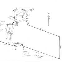
Payne Property -- North Section
Item
Description
THIS INDENTURE made the twelfth day of August in the year one thousand nine hundred and nine,
BETWEEN ANNA T. PRATT AND ELIZABETH, COMTESSE DE GASQUET JAMES of Dinard, France parties of the first part, and
WILLIAMSON W. FULLER of the City, County and State of New York, party of the second part,
WITNESSETH; - that the said parties of the first part in consideration of ONE Dollar lawful money of the United States, paid by the party of the second part, do hereby grant and release unto the said party of the second part, his heirs and assigns forever,
ALL THAT CERTAIN farm of land situate in the Town of Esopus Ulster County N. Y. adjoining the Hudson River and bounded as follows: -Beginning at the southeast corner of the farm given to John Oliver Beaver under the will of John Beaver, deceased, running thence along the north bounds of the lands formerly of the Widow Wurts now (1859) of John Jacob Actor easterly to the Hudson River at a yellow pine tree cornered and marked, then northerly along said river to the lands of Robert L. Pell, then westerly along the same to the lands formerly in the possession of the heirs of Peter Beaver now (1859) of Robert L. Pall at a cross fence and wall, then southerly along the said fence and wall to the place of beginning. Containing, 65 acres more or less.
Also all that certain other parcel of land situate in the Town and County aforesaid adjoining the above named premises and being the parcel given to John Oliver Beaver by the last will and testament of John Beaver, deceased, and bounded as follows, to wit:- On the east by the last named premises cross fence and wall, , south by lands formerly belonging to the Widow Wurts now (1859) to John Jacob Astor on the west by the public highway leading from Rondout to Newburgh and on the north by lands formerly belonging to Myer G Beaver and the farm of Robert L. Pell containing 60 acres be the same more or less. The foregoing two parcels being the same premises conveyed to the late George W. Pratt by Robert L. Pell and wife by deed dated May 24, 1859 and recorded in the Ulster County Clerk's Office July 23, 1859 in Book 108 of Deeds page 566.
Also all that certain farm or piece of land situate lying and being in the Town of Esopus, Ulster County N. Y., now (1886) in the occupation of the widow Asael G. Beaver as the homestead farm of John Beaver, deceased, and bounded generally as follows:- On the north by lands formerly belonging to the heirs or Nicholas Murphy deceased, and the factory lot, on the east by lands now or lately of Robert L. Pell, and by the above described premises of the late George W. Pratt, on the south by lands now or late of said George W. Pratt and of Archibald Russell and on the west by said factory lot and lands now or late of Cornelius Relyea, being the same premises conveyed by James Crowthers and wife to Joseph Greaves in year 1858. Excepting and reserving thereout so much of said premises as were heretofore conveyed by Robert L. Pell and wife to the Church of the Ascension for a cemetery. And also excepting and reserving therefrom the premises heretofore conveyed to the New York West Shore and Buffalo Railway Company. Being the same premises conveyed to the said Anna T. Pratt by Sarah Matilda Wygatt and Angeline E. Darling, as surviving executors of and Trustees under the last will and testament of Jacob A. Robertson by deed dated January 15, 1886 and recorded in the Clerk's Office of Ulster County January 24, 1886 in Book 264 of deeds page 433.
The grantee herein has caused the premises above described to be surveyed and a map thereof to be made which is to be filed herewith but the covenants and warranty in this deed apply only to the premises as above described, and the grantors herein do not in any manner warrant the accuracy of said survey and map.
TOGETHER WITH THE APPURTENANCES and all the estate and rights of the parties of the first part, in and to said premises.
TO HAVE AND TO HOLD the above granted premises unto the said party of the second part, his heirs and assigns forever.
And the said parties of the first part do covenant With the said party of the second part as follows:-
That the party of the second part shall quietly enjoy the said premises
That the said parties of the first pert will forever warrant the title to said premises.
IN WITNESS WHEREOF the said parties of the first part have hereunto set their hands and seals the day and year first above written.
In presence of .
Raymond Moulton Anna T. Pratt( L. S.)
Elizabeth, Comtesse de Gasquet-James (LS)
REPUBLIC OF FRANCE :
DEPARTMENT OF ILLE ET VLAINE : SS.
CITY OF ST MALO :
On this 12th day of August in the year one thousand nine hundred and nine before me, the subscriber, a Consular Agent, of the United States of America in and for said Town of St. Malo, Republic of France residing within said City of Malo personally appeared Anna. T. Pratt and Elizabeth, Comtesse de Gasquet-James, to me known and known to me to be the individuals described in and who executed the foregoing instrument, and they thereupon severally acknowledged to me that they executed the same.
Seal RaymonD Moulton,
Consular Agent of the United
$2 Fee Stamp States of America.
A true record entered
Sept. 18, 1909 at 8:27 A. M.
handwritten signature
Clerk
THIS INDENTURE, made the 28th day of October, in the year nineteen hundred and nine.
BETWEEN WILLIAMSON W. FULLER and ANNIE M. FULLER, his wife, of the City, County and State of New York, parties of the first part, and
OLIVER H. PAYNE, of the City. County and State of New York, party of the second part.
WITNESSETH. That the said parties of the first part, in consideration of one dollar and other valuable consideration, lawful money of the United States, paid by the party of the second part, do hereby remise, release and forever quit-claim and convey unto the party of the second part, his heirs and assigns forever,
ALL THAT CERTAIN tract or parcel of land, situate in the town of Esopus, Ulster County, N. Y. beginning at a point on the westerly side of the Hudson River, at the northeasterly corner of land now owned by 0. H. Payne (by deed of W. W. Fuller dated January 5. 1909) and running from thence by survey of May, 1909. north 70 degrees 37 minutes west 2823 5/10 feet to a point in the center of the highway leading from West Park to Esopus, thence north 50 minutes west along the center of said highway, 282 feet to a point, thence north 83 degrees 10 minutes west passing along the northerly side of a cemetery, 381 feet to the northwesterly corner of said cemetery, thence south 23 degrees 40 minutes west 104 feet, thence south 17 degrees 50 minutes west 68 feet, thence south 1 degree 35 minutes west 24 feet to a point in the westerly line of said cemetery, thence north 71 degrees west crossing Black Creek. and the N. Y. S. & B. Railway; and continuing along the northerly line of said Payne's (formerly Fuller's) land 1307 feet to a stone heap by a wall, thence north 2 degrees 20 minutes east along the edge of the timber, 750 feet to an old stone heap; thence south 83 degrees 57 minutes east along a row of marked trees 617 feet to an old stone, monument, thence north 13 degrees 25 minutes east along a row of marked trees, 484 feet. to a stake and stones at the southwesterly corner of what is termed the eight acre factory lot; thence south 89 degrees 45 minutes east crossing the above mentioned railway 375 5/10 feet to a point; thence north 5 degrees west along what was originally the Saw Mill pond 81 5/10 feet to a point, thence north 24 degrees 10 minutes east 52 2/10 feet to a point, thence north 47 degrees 15 minutes east 39 5/10 feet to a point, thence north 72 degrees 15 minutes east continuing along the outline of the old saw mill pond and crossing the creek, 149 feet to a point in the center of the above mentioned highway, thence north 17 degrees 15 minutes west 241 5/10 feet to a point; thence north 2. degrees west 100 feet to a point in the center of the highway; thence north 11 degrees east 100 feet, to a point in the center of tie highway. thence south 84 degrees 55 minutes east leaving the highway and passing along the southerly side of another cemetery 90 feet to the southeasterly corner thereof, thence north 8 degrees 10 minutes east along the easterly side of the last mentioned cemetery, 117 feet to a point in the easterly line thereof; thence south 76 degrees 10 minutes east along the southerly line of lands formerly of A. D. James, 85 feet to a point; thence south 80 degrees 10 minutes east 187 feet to a point, thence south 78 degrees 40 minutes east 229 feet to a point, thence south 74 degrees 50 minutes east 89 feet to a point, the southeasterly corner of said James' lands; thence along the east line of said James land north 20 degrees 35 minutes east 319 feet, to the south line of lands of Robert Beatty, thence along the lands of said Beatty the following courses and distances south 42 degrees 15 minutes east 66 feet, south 82 degrees,15 minutes east 89 foot to a corner, south 23 degrees 45 minutes west 254 feet to a corner, south 76 degrees 15 minutes east crossing a creek, 112 feet to a corner, south 26 degrees 45 minutes west on the east side of said creek. 284 feet to a corner south 73 degrees 15 minutes east 197 feet to a corner, south 7 degrees 45 minutes west 283 feet to a corner. south 70 degrees east 2514 foot to the Hudson River, thence southerly along the west side of said river 1822 feet to the place of beginning.
Excepting and reserving from the above described premises the right of way, tract or parcel of land heretofore conveyed to or acquired by the New York, West Shore and Buffalo Railway Company. Containing exclusive of said Railway Company's land, 179 635/1000 acres of land, and being the same premises conveyed by Anna T. Pratt and Elizabeth Comtesse de Gasquet James to Williamson W. Fuller, by deed dated August 12, 1909, and recorded in the Ulster County Clerk's office, September 18. 1909.
TOGETHER with the appurtenances, and all the estate and rights of the parties of the first part in and to said premises.
T0 HAVE AND TO HOLD the above mentioned and described premises unto the party of the second part, his heirs and assigns forever.
IN WITNESS whereof, the said parties of the first part have hereunto set their hands and seals the day and year first above written.
In presence of,
R. J. Boylan Williamson W. Fuller, (seal)
Annie M. Fuller. (seal)
STATE OF NEW YORK
COUNTY OF NEW YORK: SS.:
0n this 28th day of October, 1909, before me, the undersigned, personally came and appeared WILLIAMSON W. FULLER and ANNIE M. FULLER, his wife to me known and known to me to be the individuals described in and who executed the foregoing instrument, and severally acknowledged to me that they executed the same
R. J. Boylan
Notary Public No. 286, Kings County N. Y
Register's certificate no. 2025
Certificate filed in New York County, N.Y., No. 1251
My Commission expires March 30, 1911
STATE OF NEW YORK
COUNTY OF NEW YORK: ss.:
I, PETER J. DOOLING, Clerk of the County of New York, and also Clerk of the Supreme Courty for the said County, the same being a court of Record, Do hereby Certify that
R. J. BOYLAN
has filed in the Clerk's office of the County of New York, a certified copy of his appointment and qualification as Notary Public, for the County of Kings, with his autograph signature, and was at the time of taking the proof or acknowledgment, of the annexed instrument, duly authorized to take the same. And further that I am well acquainted with the the handwriting of such Notary, and believe the signature to the said certificate of proof or acknowledgment to be genuine.
IN TESTIMONY WHEREOF, I have hereunto set my hand and affixed the seal of the said Court and County, the 28 day of Oct., 1909.
Peter J. Dooling,
Clerk
A true record entered
Nov. 1, 1909, at 9:25 A. M.
Type
Map