west side -- tract A (barn buildings
Item
Description
THIS INDENTURE, made the 2nd day of May, nineteen hundred and sixty-seven, between WILTWICK SCHOOL FOR BOYS, INC., a New York membership corporation having its principal office at 260 Park Avenue South, New York, N.Y., party of the first part, and WALRUS, INC., a New York corporation having its principal place of business at 254 Fair Street, Kingston, New York, party of the second part,
WITNESSETH, that the party of the first part, in consideration of Ten ($10.00) dollars, lawful money of the United States, paid by the party of the second part, does hereby grant and release unto the party of the second part, the heirs, or successors and assigns of the party of the second part forever,
ALL that certain plot, piece or parcel of land, with the buildings and improvements thereon erected, situate, lying and being in the Town of Esopus, County of Ulster and State of New York, more particularly described on Schedule A annexed hereto and hereby made a part hereof.
TOGETHER with the right of the Grantor, if any, to cross the right-of-way of the New York Central Railroad Company adjacent to a portion of the premises.
TOGETHER with all right, title and interest, if any, of the party of the first part in and to any streets and roads abutting the above described premises to the center lines thereof,
TOGETHER with the appurtenances and all the estate and rights of the party of the first part in and to said premises,
TO HAVE AND TO HOLD the premises herein granted unto the party of the second part, the heirs or successors and assigns of the party of the second part forever.
AND the party of the first part, in compliance with section 13 of the Lien Law, covenants that the party of the first part will receive the consideration for this conveyance and will hold the right to receive such consideration as a trust fund to be applied first for the purpose of paying the cost of the improvement and will apply the same first to the payment of the cost of the improvement before using any part of the total of the same for any other purpose.
The word "party" shall be construed as if it read "parties" whenever the sense of this indenture so requires.
IN WITNESS WHEREOF, the party of the first part has duly executed this deed the day and year first above written.
WILTWYCK SCHOOL FOR BOYS, INC.
By Carl M. Spero, Treasurer
STATE OF NEW YORK, COUNTY OF NEW YORK
On the 2nd day of May, 1967, before me personally came Carl M. Spero to me known, who, being by me duly sworn, did depose and say that he resides at No. 139 East 94th Street, New York, N.Y., that he is the Treasurer of Wiltwyck School for Boys, Inc., the corporation described in and which executed the foregoing instrument; that he knows the seal of said corporation; that the seal affixed to said instrument is such corporate seal; that it was so affixed by order of the board of directors of said corporation, and that he signed his name thereto by like order.
Joseph E. Browdy
Notary Public, State of New York
Qualified in New York County
Commission Expires March 30, 1968
Filed 2:06 PM, May 17, 1967 Albert Spada, Ulster County Clerk
Schedule A
Annexed to and Forming Part of Deed dated May 1, 1967 from Wiltwyck School for Boys, Inc. to Walrus, Inc.
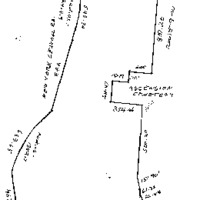
All that plot of land with the building thereon in the Town of Esopus, County of Ulster and State of New York, bounded and described as follows: -- BEGINNING at a point on the westerly side of the State Highway leading from Highland to Kingston known as Route 9-W adjoining the northeast corner of land now or formerly belonging to Dr. Gordon and a stone wall; thence running along the northerly line of said land now or formerly of Dr. Gordon the following courses and distances: north sixty-five degrees fifty-two minutes forty seconds west one hundred and twelve and seventy-five one-hundredths feet; north sixty-seven degrees twenty-one minutes thirty seconds west three hundred and seventy-six and ninety-nine one-hundredths feet; north sixty-six degrees forty-five minutes twenty seconds west seven hundred and forty and thirty one-hundredths feet; north sixty-six degrees fifty-five minutes fifth seconds west two hundred and thirty-seven and twenty-nine one-hundredths feet to the easterly line of land of the New York Central Railroad Company, formerly West Shore Railroad, thence running the following courses and distances for the easterly line of said Railroad land north nine degrees seventeen minutes no seconds west four hundred and fifty-seven and 6 one-hundredths feet; northwesterly on a curve to the right having a radius of one thousand three hundred and eighty-two and seven tenths feet a distance of six hundred and sixty-three and sixty-five one-hundredths feet north eighteen degrees thirteen minutes no seconds east eight hundred and eighty-three feet, northerly on a curve to the left having a radius of two thousand nine hundred and fourteen and nine tenths feet a distance of five hundred and forty-three and thirty-four one-hundredths feet and north seven degrees thirty-two minutes no seconds east four hundred and five and sixty eight one-hundredths feet to the southerly line of land now or formerly of Henken; thence south eighty-eight degrees twelve minutes forth seconds east part of the way along the center line of a stone wall one hundred and ninety-five and thirty-five one-hundredths feet to another corner of said land now or formerly of Henken; thence running still along said last mentioned land north three degrees forty-two minutes no seconds east forty-one and eighty-five one-hundredths feet; north thirteen degrees four minutes ten seconds west sixty-four and seventy-four one-hundredths feet; north eight degrees fifty-seven minutes ten seconds west sixteen and twenty-six one-hundredths feet; north thirty-one degrees twenty-eight minutes fifty seconds east nineteen and seventy-eight one-hundredths feet and north sixty-eight degrees fifty-two minutes ten seconds east two hundred and two and sixty-two one-hundredths feet to the center line of the old Post Road; thence through the center line of the old Post Road the following courses and distances: south fourteen degrees fifty-eight minutes ten seconds east fifty-four and eighty-nine one-hundredths feet; thence south nineteen degrees eleven minutes twenty seconds east fifty-one and seventy-two one-hundredths feet; thence south twenty-five degrees thirty-four minutes thirty seconds east fifty and three one-hundredths feet; thence south twenty-eight degrees twenty-five minutes no seconds east three hundred thirty-five and no one-hundredths feet; then south thirty-two degrees nine minutes no seconds east two hundred thirty-four and fifty-seven one-hundredths feet; thence south one degree twenty-one minutes thirty seconds west one hundred and thirty-four and nineteen one-hundredths feet; and south five degrees nine minutes no seconds west eight hundred and seven and twenty one-hundredths feet; to the northeast corner of land conveyed by New York Protestant Episcopal City Mission Society to Church of the Ascension for a cemetery; thence running along the northerly line of said last mentioned land north eighty-one degrees thirty-seven minutes no seconds west two hundred feet to the northwest corner of said cemetery plot; thence running along the westerly line of said land so conveyed to the Church of the Ascension south three degrees thirty-five minutes seventeen seconds west one hundred and ten feet to the northerly line of another cemetery parcel belonging to the Church of the Ascension at a stone wall; thence running along the center lineof said stone wall north eighty-one degrees thirty-seven minutes no seconds west one hundred and forty-seven and nineteen one-hundredths feet to a stone wall; thence running along the westerly line of said cemetery parcel belonging to the Church of the Ascension and along the easterly line of a small part of said cemetery parcel conveyed by the Church of the Ascension to New York Protestant Episcopal City mission Society south three degrees forty-one minutes five seconds west two hundred and eleven and forty-seven one-hundredths feet; to the southerly line of said cemetery parcel of the Church of the Ascension at a stone wall; thence running along the southerly line of said last mentioned land and along the center line of said stone wall south eighty-one degrees fifty-seven minutes twenty seconds east three hundred and fifty-four and forty-six one-hundredths feet; to the westerly side of the said highway leading from Highland to Kingston, known as Route 9-W and thence along the westerly side of said State Highway, known as Route 9-W the following courses and distances: south one degree thirty-nine minutes no seconds west two hundred and sixteen and twenty-seven one-hundredths feet; south four degrees two minutes no seconds west five hundred and twenty one-hundredths feet; south six degrees thirty-nine minutes no seconds east one hundred and fifty-one and ninety one-hundredths feet; south four degrees twenty eight minutes ten seconds east sixty-one and thirty-four one-hundredths feet; south sixteen degrees fifty-one minutes no seconds east twenty-six and eighty-four one-hundredths feet; and south twenty degrees forty-one minutes no seconds east eight hundred and sixty-two and five one-hundredths feet; to the point of beginning.
this is a transcription of a deed located in the Ulster County Clerk's Vault Room, Kingston, New York
THIS INDENTURE, Made the 5th day of November, Nineteen Hundred and Sixty-Eight Between Walrus, Inc., a corporation organized under the laws of the State of New York, with its principal place of business located at 254 Fair Street, Kingston, Ulster County, New York, party of the first part, and PHILIP P. HELLRIEGEL AND JAMES R. SHIELDS, both of P. O. Box 92, Esopus, Ulster County, New York, as tenants in common, parties of the second part,
WITNESSETH that the party of the first part, in consideration of TEN and 00/100 Dollar ($10.00) lawful money of the United States, and other good and valuable consideration paid by the parties of the second part, does hereby grant and release unto the parties of the second part, their distributees and assigns forever
ALL THAT PLOT OF LAND with the buildings thereon in the Town of Esopus County of Ulster and State of New York, bounded and described as follows:
BEGINNING at a point on the Westerly side of the State Highway leading from Highland to Kingston, known as Route 9 -W adjoining the Northeast corner of land now or formerly belonging to Dr. Gordon and a stone wall; thence running along the Northerly line of said land now or formerly of Dr. Cordon the following courses and distances: North 65º 52 , 40"West 112 .75 feet; North 67º 21' 30" West 376.99 feet; North 66º 45' 20" West 740.30 feet; North 66º 55' 50" West 237.29 feet to the Easterly line of land of the New York Central Railroad Company, formerly West Shore Railroad, thence running the following courses and distances for the Easterly line of said Railroad land North 9º17' 00" West 457.06 feet; Northwesterly on a curve to the right having a radius of 1382.7 feet a distance of 663.65 feet, North 18° 13' 00" East 883 feet; Northerly on a curve to the left having a radius of 2914.9 feet a distance of 543.34 feet and North 7º 32, 00" East 405.68 feet to the Southerly line of land now or formerly of Henken South 88º 12' 40" East part of the way along the center line of a stone wall 195.35 feet to another corner of said land now or formerly of Henken; thence running still along said last mentioned land North 3º 42' 00" East 41.85 feet; North 13º 4' 10" West 64.74 feet; North 8º 57' 10" West 16.26 feet; North 31º 28' 50" East 19.78 feet and North 68º 52' 10" East 202.62 feet to the center line of the Old Post Road; thence through the center line of the Old Post Road the following courses and distances: South 14º 58' 10" East 54 89 feet, thence South 19º 11' 20" East 51.72 feet; thence South 25º 34' 30" East 50.03 feet; thence South 28º 25' 00" East 335.00 feet; thence south 32º 9' 00" East 234.57 feet; thence South 19º 21' 30" West 134.19 feet and South 5º 9' --" West 807.20 feet to the Northeast corner of land conveyed by New York Protestant Episcopal City Mission Society to Church of the Ascension for a cemetery; thence running along the Northerly line of said last mentioned land North 81º 37' 00" West 200 feet to the Northwest corner of said cemetery plot; thence running along the Westerly line of said land so conveyed to the Church of the Ascension South 3º 35' 17" West 110 feet to the Northerly line of another cemetery parcel belonging to the Church of the Ascension a t a stone wall; thence running along the Northerly line of said cemetery parcel of the Church of the Ascension and along the center line of said stone wall North 81º 37' 00" West 147.19 feet to a stone wall; thence running along the Westerly line of said cemetery parcel belonging to the Church of the Ascension and along the Easterly line of a small part of said cemetery parcel conveyed by the Church of the Ascension to New York Protestant Episcopal City Mission Society South 3º 41' 5" West 211.47 feet to the Southerly line of said Cemetery parcel of the Church of the Ascension at a stone wall; thence running along the Southerly line of said last mentioned land and along the center line of said stone wall South 81º 57" 20" East 354.46 feet to the Westerly side of the said highway leading from-Highland to Kingston, known as Route 9-W and thence along the Westerly side of said State Highway, known as Route 9-W the following courses and distances: South 1º 39' 00" West 16.27 feet; South 4º 2' 00" West 500.20 feet; South 6º 39' 00" East 151.90 feet; South 4º 28' 10" East 61.34 feet; South 16º 51' 00" East 26.84 feet and South 20º 41' 00" East 862.05 feet to the point of beginning.
SUBJECT to the rights of the public to any highway adjacent to said premises.
SUBJECT to the rights of New York Central and/or West Shore Railroad in the right of way running through said premises.
SUBJECT to any state of facts which a survey may show.
SUBJECT to any public utilities or other easements under recorded agreements.
EXCEPTING from the said premises a reservoir or pump house and a right of way leading therefrom as granted to Lewis F. Mc Laren in a deed from the seller dated September 11th, 1968, and recorded in the Ulster County Clerks Office in Liber 1218 of Deeds at Page 485 on September 25, 1968.
TOGETHER with the right of the Grantor if any, to cross the right-of-way of the N. Y. Central Railroad Company adjacent to a portion of the premises.
TOGETHER with the appurtenances and all the estate and rights of the party of the first part in and to said premises,
TO HAVE AND TO HOLD the premises herein granted unto the parties of the second part, their heirs and assigns forever.
AND the party of the first part, in compliance with section 13 of the Lien Law, covenants that the party of the first part will receive the consideration for this conveyance and will hold the right to receive such consideration as a trust fund to be applied first for the purpose of paying the cost of the improvement and will apply the same first to the payment of the cost of the improvement before using any part of the total of the same for any other purpose.
IN WITNESS WHEREOF, the party of the first part haws caused its corporate seal to be hereunto affixed, and these presents to be signed by its duly authorized officer this 5th day of November Nineteen Hundred and sixty Eight.
WALRUS, INC.
By Walter R. Seaman
State of New York }
County of Ulster } ss.
On this fifth day of November, Nineteen Hundred and Sixty-eight before me personally came Walter R. Seaman, to me personally know, who, being by me duly sworn, did depose and say that he resided in the Town of Esopus, Ulster County, New York; that he is the President of WALRUS, INC., the corporation described in, and which executed, the within instrument; that he knows the seal of said corporation; that the seal affixed to said Instrument is such corporate seal; that is was so affixed by order of the Board of Directors of said corporation; and that he signed his name thereto by like order.
George Rusk, Jr.
Notary Public, State of New York
Appointed in Ulster County]
Commission Expires March 30, 1969
Filed 9:00 A. M., Nov 8, 1968 Albert Spada, Ulster County Clerk
WITNESSETH, that the party of the first part, in consideration of Ten ($10.00) dollars, lawful money of the United States, paid by the party of the second part, does hereby grant and release unto the party of the second part, the heirs, or successors and assigns of the party of the second part forever,
ALL that certain plot, piece or parcel of land, with the buildings and improvements thereon erected, situate, lying and being in the Town of Esopus, County of Ulster and State of New York, more particularly described on Schedule A annexed hereto and hereby made a part hereof.
TOGETHER with the right of the Grantor, if any, to cross the right-of-way of the New York Central Railroad Company adjacent to a portion of the premises.
TOGETHER with all right, title and interest, if any, of the party of the first part in and to any streets and roads abutting the above described premises to the center lines thereof,
TOGETHER with the appurtenances and all the estate and rights of the party of the first part in and to said premises,
TO HAVE AND TO HOLD the premises herein granted unto the party of the second part, the heirs or successors and assigns of the party of the second part forever.
AND the party of the first part, in compliance with section 13 of the Lien Law, covenants that the party of the first part will receive the consideration for this conveyance and will hold the right to receive such consideration as a trust fund to be applied first for the purpose of paying the cost of the improvement and will apply the same first to the payment of the cost of the improvement before using any part of the total of the same for any other purpose.
The word "party" shall be construed as if it read "parties" whenever the sense of this indenture so requires.
IN WITNESS WHEREOF, the party of the first part has duly executed this deed the day and year first above written.
WILTWYCK SCHOOL FOR BOYS, INC.
By Carl M. Spero, Treasurer
STATE OF NEW YORK, COUNTY OF NEW YORK
On the 2nd day of May, 1967, before me personally came Carl M. Spero to me known, who, being by me duly sworn, did depose and say that he resides at No. 139 East 94th Street, New York, N.Y., that he is the Treasurer of Wiltwyck School for Boys, Inc., the corporation described in and which executed the foregoing instrument; that he knows the seal of said corporation; that the seal affixed to said instrument is such corporate seal; that it was so affixed by order of the board of directors of said corporation, and that he signed his name thereto by like order.
Joseph E. Browdy
Notary Public, State of New York
Qualified in New York County
Commission Expires March 30, 1968
Filed 2:06 PM, May 17, 1967 Albert Spada, Ulster County Clerk
Schedule A
Annexed to and Forming Part of Deed dated May 1, 1967 from Wiltwyck School for Boys, Inc. to Walrus, Inc.
All that plot of land with the building thereon in the Town of Esopus, County of Ulster and State of New York, bounded and described as follows: -- BEGINNING at a point on the westerly side of the State Highway leading from Highland to Kingston known as Route 9-W adjoining the northeast corner of land now or formerly belonging to Dr. Gordon and a stone wall; thence running along the northerly line of said land now or formerly of Dr. Gordon the following courses and distances: north sixty-five degrees fifty-two minutes forty seconds west one hundred and twelve and seventy-five one-hundredths feet; north sixty-seven degrees twenty-one minutes thirty seconds west three hundred and seventy-six and ninety-nine one-hundredths feet; north sixty-six degrees forty-five minutes twenty seconds west seven hundred and forty and thirty one-hundredths feet; north sixty-six degrees fifty-five minutes fifth seconds west two hundred and thirty-seven and twenty-nine one-hundredths feet to the easterly line of land of the New York Central Railroad Company, formerly West Shore Railroad, thence running the following courses and distances for the easterly line of said Railroad land north nine degrees seventeen minutes no seconds west four hundred and fifty-seven and 6 one-hundredths feet; northwesterly on a curve to the right having a radius of one thousand three hundred and eighty-two and seven tenths feet a distance of six hundred and sixty-three and sixty-five one-hundredths feet north eighteen degrees thirteen minutes no seconds east eight hundred and eighty-three feet, northerly on a curve to the left having a radius of two thousand nine hundred and fourteen and nine tenths feet a distance of five hundred and forty-three and thirty-four one-hundredths feet and north seven degrees thirty-two minutes no seconds east four hundred and five and sixty eight one-hundredths feet to the southerly line of land now or formerly of Henken; thence south eighty-eight degrees twelve minutes forth seconds east part of the way along the center line of a stone wall one hundred and ninety-five and thirty-five one-hundredths feet to another corner of said land now or formerly of Henken; thence running still along said last mentioned land north three degrees forty-two minutes no seconds east forty-one and eighty-five one-hundredths feet; north thirteen degrees four minutes ten seconds west sixty-four and seventy-four one-hundredths feet; north eight degrees fifty-seven minutes ten seconds west sixteen and twenty-six one-hundredths feet; north thirty-one degrees twenty-eight minutes fifty seconds east nineteen and seventy-eight one-hundredths feet and north sixty-eight degrees fifty-two minutes ten seconds east two hundred and two and sixty-two one-hundredths feet to the center line of the old Post Road; thence through the center line of the old Post Road the following courses and distances: south fourteen degrees fifty-eight minutes ten seconds east fifty-four and eighty-nine one-hundredths feet; thence south nineteen degrees eleven minutes twenty seconds east fifty-one and seventy-two one-hundredths feet; thence south twenty-five degrees thirty-four minutes thirty seconds east fifty and three one-hundredths feet; thence south twenty-eight degrees twenty-five minutes no seconds east three hundred thirty-five and no one-hundredths feet; then south thirty-two degrees nine minutes no seconds east two hundred thirty-four and fifty-seven one-hundredths feet; thence south one degree twenty-one minutes thirty seconds west one hundred and thirty-four and nineteen one-hundredths feet; and south five degrees nine minutes no seconds west eight hundred and seven and twenty one-hundredths feet; to the northeast corner of land conveyed by New York Protestant Episcopal City Mission Society to Church of the Ascension for a cemetery; thence running along the northerly line of said last mentioned land north eighty-one degrees thirty-seven minutes no seconds west two hundred feet to the northwest corner of said cemetery plot; thence running along the westerly line of said land so conveyed to the Church of the Ascension south three degrees thirty-five minutes seventeen seconds west one hundred and ten feet to the northerly line of another cemetery parcel belonging to the Church of the Ascension at a stone wall; thence running along the center lineof said stone wall north eighty-one degrees thirty-seven minutes no seconds west one hundred and forty-seven and nineteen one-hundredths feet to a stone wall; thence running along the westerly line of said cemetery parcel belonging to the Church of the Ascension and along the easterly line of a small part of said cemetery parcel conveyed by the Church of the Ascension to New York Protestant Episcopal City mission Society south three degrees forty-one minutes five seconds west two hundred and eleven and forty-seven one-hundredths feet; to the southerly line of said cemetery parcel of the Church of the Ascension at a stone wall; thence running along the southerly line of said last mentioned land and along the center line of said stone wall south eighty-one degrees fifty-seven minutes twenty seconds east three hundred and fifty-four and forty-six one-hundredths feet; to the westerly side of the said highway leading from Highland to Kingston, known as Route 9-W and thence along the westerly side of said State Highway, known as Route 9-W the following courses and distances: south one degree thirty-nine minutes no seconds west two hundred and sixteen and twenty-seven one-hundredths feet; south four degrees two minutes no seconds west five hundred and twenty one-hundredths feet; south six degrees thirty-nine minutes no seconds east one hundred and fifty-one and ninety one-hundredths feet; south four degrees twenty eight minutes ten seconds east sixty-one and thirty-four one-hundredths feet; south sixteen degrees fifty-one minutes no seconds east twenty-six and eighty-four one-hundredths feet; and south twenty degrees forty-one minutes no seconds east eight hundred and sixty-two and five one-hundredths feet; to the point of beginning.
this is a transcription of a deed located in the Ulster County Clerk's Vault Room, Kingston, New York
THIS INDENTURE, Made the 5th day of November, Nineteen Hundred and Sixty-Eight Between Walrus, Inc., a corporation organized under the laws of the State of New York, with its principal place of business located at 254 Fair Street, Kingston, Ulster County, New York, party of the first part, and PHILIP P. HELLRIEGEL AND JAMES R. SHIELDS, both of P. O. Box 92, Esopus, Ulster County, New York, as tenants in common, parties of the second part,
WITNESSETH that the party of the first part, in consideration of TEN and 00/100 Dollar ($10.00) lawful money of the United States, and other good and valuable consideration paid by the parties of the second part, does hereby grant and release unto the parties of the second part, their distributees and assigns forever
ALL THAT PLOT OF LAND with the buildings thereon in the Town of Esopus County of Ulster and State of New York, bounded and described as follows:
BEGINNING at a point on the Westerly side of the State Highway leading from Highland to Kingston, known as Route 9 -W adjoining the Northeast corner of land now or formerly belonging to Dr. Gordon and a stone wall; thence running along the Northerly line of said land now or formerly of Dr. Cordon the following courses and distances: North 65º 52 , 40"West 112 .75 feet; North 67º 21' 30" West 376.99 feet; North 66º 45' 20" West 740.30 feet; North 66º 55' 50" West 237.29 feet to the Easterly line of land of the New York Central Railroad Company, formerly West Shore Railroad, thence running the following courses and distances for the Easterly line of said Railroad land North 9º17' 00" West 457.06 feet; Northwesterly on a curve to the right having a radius of 1382.7 feet a distance of 663.65 feet, North 18° 13' 00" East 883 feet; Northerly on a curve to the left having a radius of 2914.9 feet a distance of 543.34 feet and North 7º 32, 00" East 405.68 feet to the Southerly line of land now or formerly of Henken South 88º 12' 40" East part of the way along the center line of a stone wall 195.35 feet to another corner of said land now or formerly of Henken; thence running still along said last mentioned land North 3º 42' 00" East 41.85 feet; North 13º 4' 10" West 64.74 feet; North 8º 57' 10" West 16.26 feet; North 31º 28' 50" East 19.78 feet and North 68º 52' 10" East 202.62 feet to the center line of the Old Post Road; thence through the center line of the Old Post Road the following courses and distances: South 14º 58' 10" East 54 89 feet, thence South 19º 11' 20" East 51.72 feet; thence South 25º 34' 30" East 50.03 feet; thence South 28º 25' 00" East 335.00 feet; thence south 32º 9' 00" East 234.57 feet; thence South 19º 21' 30" West 134.19 feet and South 5º 9' --" West 807.20 feet to the Northeast corner of land conveyed by New York Protestant Episcopal City Mission Society to Church of the Ascension for a cemetery; thence running along the Northerly line of said last mentioned land North 81º 37' 00" West 200 feet to the Northwest corner of said cemetery plot; thence running along the Westerly line of said land so conveyed to the Church of the Ascension South 3º 35' 17" West 110 feet to the Northerly line of another cemetery parcel belonging to the Church of the Ascension a t a stone wall; thence running along the Northerly line of said cemetery parcel of the Church of the Ascension and along the center line of said stone wall North 81º 37' 00" West 147.19 feet to a stone wall; thence running along the Westerly line of said cemetery parcel belonging to the Church of the Ascension and along the Easterly line of a small part of said cemetery parcel conveyed by the Church of the Ascension to New York Protestant Episcopal City Mission Society South 3º 41' 5" West 211.47 feet to the Southerly line of said Cemetery parcel of the Church of the Ascension at a stone wall; thence running along the Southerly line of said last mentioned land and along the center line of said stone wall South 81º 57" 20" East 354.46 feet to the Westerly side of the said highway leading from-Highland to Kingston, known as Route 9-W and thence along the Westerly side of said State Highway, known as Route 9-W the following courses and distances: South 1º 39' 00" West 16.27 feet; South 4º 2' 00" West 500.20 feet; South 6º 39' 00" East 151.90 feet; South 4º 28' 10" East 61.34 feet; South 16º 51' 00" East 26.84 feet and South 20º 41' 00" East 862.05 feet to the point of beginning.
SUBJECT to the rights of the public to any highway adjacent to said premises.
SUBJECT to the rights of New York Central and/or West Shore Railroad in the right of way running through said premises.
SUBJECT to any state of facts which a survey may show.
SUBJECT to any public utilities or other easements under recorded agreements.
EXCEPTING from the said premises a reservoir or pump house and a right of way leading therefrom as granted to Lewis F. Mc Laren in a deed from the seller dated September 11th, 1968, and recorded in the Ulster County Clerks Office in Liber 1218 of Deeds at Page 485 on September 25, 1968.
TOGETHER with the right of the Grantor if any, to cross the right-of-way of the N. Y. Central Railroad Company adjacent to a portion of the premises.
TOGETHER with the appurtenances and all the estate and rights of the party of the first part in and to said premises,
TO HAVE AND TO HOLD the premises herein granted unto the parties of the second part, their heirs and assigns forever.
AND the party of the first part, in compliance with section 13 of the Lien Law, covenants that the party of the first part will receive the consideration for this conveyance and will hold the right to receive such consideration as a trust fund to be applied first for the purpose of paying the cost of the improvement and will apply the same first to the payment of the cost of the improvement before using any part of the total of the same for any other purpose.
IN WITNESS WHEREOF, the party of the first part haws caused its corporate seal to be hereunto affixed, and these presents to be signed by its duly authorized officer this 5th day of November Nineteen Hundred and sixty Eight.
WALRUS, INC.
By Walter R. Seaman
State of New York }
County of Ulster } ss.
On this fifth day of November, Nineteen Hundred and Sixty-eight before me personally came Walter R. Seaman, to me personally know, who, being by me duly sworn, did depose and say that he resided in the Town of Esopus, Ulster County, New York; that he is the President of WALRUS, INC., the corporation described in, and which executed, the within instrument; that he knows the seal of said corporation; that the seal affixed to said Instrument is such corporate seal; that is was so affixed by order of the Board of Directors of said corporation; and that he signed his name thereto by like order.
George Rusk, Jr.
Notary Public, State of New York
Appointed in Ulster County]
Commission Expires March 30, 1969
Filed 9:00 A. M., Nov 8, 1968 Albert Spada, Ulster County Clerk
Type
Map