west side -- tract C (near West Park Road--now Floyd Ackert Road)
Item
Description
THIS INDENTURE, made the 2nd day of May, nineteen hundred and sixty-seven, between WILTWICK SCHOOL FOR BOYS, INC., a New York membership corporation having its principal office at 260 Park Avenue South, New York, N.Y., party of the first part, and WALRUS, INC., a New York corporation having its principal place of business at 254 Fair Street, Kingston, New York, party of the second part,
WITNESSETH, that the party of the first part, in consideration of Ten ($10.00) dollars, lawful money of the United States, paid by the party of the second part, does hereby grant and release unto the party of the second part, the heirs, or successors and assigns of the party of the second part forever,
ALL that certain plot, piece or parcel of land, with the buildings and improvements thereon erected, situate, lying and being in the Town of Esopus, County of Ulster and State of New York, more particularly described in Schedule A annexed hereto and hereby made a part hereof.
TOGETHER with the right of the Grantor, if any, to cross the right-of-way of the New York Central Railroad Company adjacent to a portion of the premises.
TOGETHER with all right, title and interest, if any, of the party of the first part in and to any streets and roads abutting the above described premises to the center lines thereof,
TOGETHER with the appurtenances and all the estate and rights of the party of the first part in and to said premises,
TO HAVE AND TO HOLD the premises herein granted unto the party of the second part, the heirs or successors and assigns of the party of the second part forever.
AND the party of the first part, in compliance with section 13 of the Lien Law, covenants that the party of the first part will receive the consideration for this conveyance and will hold the right to receive such consideration as a trust fund to be applied first for the purpose of paying the cost of the improvement and will apply the same first to the payment of the cost of the improvement before using any part of the total of the same for any other purpose.
The word "party" shall be construed as if it read "parties" whenever the sense of this indenture so requires.
IN WITNESS WHEREOF, the party of the first part has duly executed this deed the day and year first above written.
WILTWYCK SCHOOL FOR BOYS, INC.
By Carl M. Spero, Treasurer
STATE OF NEW YORK, COUNTY OF NEW YORK
On the 2nd day of May, 1967, before me personally came Carl M. Spero to me known, who, being by me duly sworn, did depose and say that he resides at No. 139 East 94th Street, New York, N.Y., that he is the Treasurer of Wiltwyck School for Boys, Inc., the corporation described in and which executed the foregoing instrument; that he knows the seal of said corporation; that the seal affixed to said instrument is such corporate seal; that it was so affixed by order of the board of directors of said corporation, and that he signed his name thereto by like order.
Joseph E. Browdy
Notary Public, State of New York
No. 31-5468875 Qualified in New York County
Commission Expires March 30, 1968
Filed 2:06 PM, May 17, 1967 Albert Spada, Ulster County Clerk
Schedule A
ALL THAT PLOT OF LAND with the Buildings thereon situate in the
Town of Esopus, County of Ulster end State of New York. bounded and described as follows:
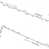
BEGINNING at a point in the. northerly line of said land now or formerly of Dr. Gordon distant as measured along, same north sixty-five degrees fifty-two minutes forty seconds west one hundred and twelve and seventy-five one-hundredths feet; north sixty-seven degrees twenty-one minutes thirty seconds west three hundred and seventy-six and ninety-nine one-hundredths feet; north sixty-six degrees forty-five minutes twenty seconds west seven hundred and forty and thirty one-hundredths feet and north sixty-six degrees fifty-five minutes fifty seconds west two hundred and thirty-seven and twenty-nine one-hundredths feet, and north sixty-six degrees fifty-five minutes fifty seconds west one hundred eighteen and thirty-eight one-hundredths feet from the westerly side of the State Highway leading from Highland to Kingston, known as Route 9-W being also the westerly line of lands of the New York Central Railroad Company, known as the West Shore Railroad, north sixty-seven degrees sixteen minutes no seconds west three hundred and sixty-three and two one-hundredths feet; north sixty-six degrees forty-six minutes forty seconds west two hundred and seventy-nine and thirty-seven one-hundredths feet; north sixty-seven degrees forty-five minutes thirty seconds west one hundred and nine and forty-three one-hundredths feet; north sixty-seven degrees thirty-six minutes twenty seconds west one hundred and four and eighteen one-hundredths feet; north sixty-six degrees thirty-seven minutes fifty seconds west one hundred and seventeen and fifteen one-hundredths feet; north sixty-six degrees eleven minutes fifty seconds west one hundred and seventy-three and seven one-hundredths feet; north sixty-seven degrees eight minutes fifty seconds west three hundred and twenty-three and eighty-eight one-hundredths feet; north sixty-six degrees thirty-nine minutes thirty seconds west one thousand one hundred and fifty-six and sixty-five one-hundredths feet; north sixty-seven degrees twenty-one minutes fifty seconds west one hundred and ninety-eight and forty-nine one-hundredths feet; north sixty-six degrees forty-five minutes no seconds west five hundred and three and ninety-six one-hundredths feet; north sixty-seven degrees forty-six minutes thirty seconds west one hundred and twenty-nine and fifty-seven one-hundredths feet; north sixty-five degrees fifty-seven minutes forty seconds west one hundred arid eighty-nine and eighty-five one-hundredths feet, and north sixty-seven degrees fifty minutes fifty seconds west two hundred and sixty-nine and seventy-four one
hundredths feet to the northwest corner of said land now or formerly of Dr:. Gordon; thence running along the westerly line of. said last mentioned. the following courses and distances: south sixteen degrees ten minutes forty seconds west two-hundred and thirty and sixty-four one-hundredths feet; south twelve degrees fifty-nine minutes no seconds west two hundred and eighty-seven and four, one-hundredths feet; south fifteen degrees thirty-one minutes fifty seconds west .two hundred and ninety-six and twenty-five one-hundredths feet and south seventeen degrees no minutes ten seconds west four hundred and forty-one and thirty-three one -hundredths feet to the northerly side of the highway known as West Park Road; thence running
along the northerly side of said highway known as West Park Road, north sixty-three degrees forty-eight minutes fifty seconds west four hundred and ninety-three and sixty-nine one-hundredths feet to the center line of said. highway known as West Park Road, and thence running along said center line of West Park Road the following courses and distances: north forty-four degrees fifty-one minutes thirty seconds west seventy-seven and twenty-two one-hundredths feet; north twenty-five degrees fifty-five minutes twenty seconds west sixty-two and eighty-nine one-hundredths feet; north seven degrees fifty-six minutes ten seconds east fifty-eight and fifty-two one-hundredths feet; north twenty-four degrees seven minutes ten seconds east one hundred and thirty-two and sixty-eight one-hundredths feet; north five degrees thirty-six minutes fifty seconds east seventy-five and sixty-three one-hundredths feet; north forty-one degrees thirty-four minutes fifty seconds west sixty-nine and eighty-two one-hundredths feet; north fifty-six
degrees nineteen minutes no seconds west two-hundred-and twenty-four and fifty-five one-hundredths feet; north thirty-three degrees fifteen minutes forty seconds west seventy-six and-fifty one-hundredths feet; north six degrees fifty minutes thirty seconds west seventy-nine and ninety-two one-hundredths feet; north twenty-five degrees thirty-eight minutes twenty seconds east one hundred and nineteen and seventeen one-hundredths feet; north five degrees sixteen minutes twenty seconds west one hundred .and five and thirty-six one-hundredths feet; north thirty degrees fifty-two minutes ten seconds west two hundred and forty-four and eighty-four one-hundredths feet and north eight degrees twenty-four minutes fifty seconds west two hundred and seventy-one and eight one-hundredths feet; thence leaving said center line of West Park Road and running north nine degrees forty-seven minutes no seconds east forty-five and seventy-two one-hundredths feet to the northeasterly side of West Park Road, and a corner of land now or formerly of Freer; thence running along the easterly line of said land of Freer north twenty degrees fourteen minutes no seconds east seven hundred and twenty-one and eighty-nine one-hundredths, feet and north fifty degrees forty-eight minutes fifty seconds east six hundred and sixty-three and twelve one-hundredths feet to the corner of two wire fences and the southerly line of land now or formerly of Kataski; thence running along the southerly line of said land of Kataski and part of the way along the center line of a stone wall the following courses and distances: south sixty-nine degrees twenty-three minutes twenty seconds east one hundred and eighty-three and eighty-five one-hundredths feet; south sixty-eight degrees fifty-one minutes twenty seconds east one hundred and ninety-two and ninety-four one-hundredths feet; south sixty-nine degrees twenty-two minutes twenty seconds east one hundred and thirty-one and eighty-four one-hundredths feet; south sixty-nine degrees twenty-three minutes thirty seconds east three hundred and sixteen and nineteen one-hundredths feet; south sixty-eight degrees twenty-five minutes no seconds east one hundred and and sixty-seven and twenty-seven one-hundredths feet; south sixty-nine degrees eight minutes no seconds east one hundred and seventy-six and twenty-seven one-hundredths feet; south sixty-six degrees forty-six minutes forty seconds east two hundred and twenty-nine and sixty-nine one-hundredths feet; south seventy-four degrees forty-five minutes fifty seconds east one hundred and forty-one and ninety-eight one-hundredths feet; south sixty-eight degrees thirty minutes forty seconds east four hundred and forty-two and thirty-six one-hundredths feet; south sixty-six degrees six minutes no seconds east thirty-eight and ninety-seven one-hundredths feet; south sixty-seven degrees forty-nine minutes ten seconds east one hundred and twenty-four and forty-two one-hundredths feet; south sixty-nine degrees twenty minutes forty seconds east three hundred and four and seventy-one one-hundredths feet; south sixty-nine degrees thirty-four minutes ten seconds east. four hundred and thirty-nine and eighty one-hundredths feet; south seventy degrees
forty-four minutes fifty seconds east one hundred and sixty-six and thirteen one-hundredths feet; south sixty-seven degrees fifty-six minutes fifty seconds east ninety-nine and sixty-two one-hundredths feet; south sixty-seven degrees fifty- four minutes forty seconds east one hundred and eleven and seven one-hundredths feet; south sixty-nine degrees no minutes thirty seconds east one hundred and ninety and eight one-hundredths feet and south sixty-eight degrees forty-nine minutes twenty seconds east four hundred and forty-six and forty-one one-hundredths feet to the end of said stone wall and the southeast corner of said land now or formerly of Kataski thence running along the easterly line of said last mentioned land north ten degrees sixteen minutes no seconds west two hundred and four and five one-hundredths feet and north three degrees fifty-six minutes. forty seconds east five hundred and sixty-six and twenty-nine one-hundredths feet to a corner of two wire fences and land now or formerly of Henken; thence running along the southerly line of said land of Henken south eighty-four degrees one minute ten seconds east six hundred and seven and forty-five one-hundredths feet to another corner of said last mentioned land, and thence running along the easterly line of said land of Henken, north sixteen degrees thirteen minutes forty-seconds east sixty-six and thirty-one one-hundredths feet; north fifteen degrees fourteen minutes no seconds east one hundred and ninety-nine and eighty-four one-hundredths feet; north fourteen degrees forty-two minutes thirty seconds east one hundred and; two and thirty-six one-hundredths feet and north fifteen degrees twenty minutes twenty seconds east one hundred and twelve and fifty-eight one-hundredths feet to a corner of two wire fences at an angle point in said land now or formerly of Henken; thence still running along said last mentioned land south eighty-eight degrees twelve minutes forty seconds east ninety-one and six one-hundredths feet to the westerly line of land of the New York Central Railroad Company, formerly West Shore Railroad thence running the following courses and distances for the westerly line of said land of the New York Central Railroad Company: south seven degrees thirty-two minutes no seconds west three hundred and ninety-five and sixty-one one-hundredths feet, southerly on a curve to the right having a radius of two thousand eight hundred and fourteen and nine tenths feet a distance of five hundred and twenty-four and seventy one-hundredths feet ; south eighteen degrees thirteen minutes no seconds west eight hundred and eighty-three feet; southeasterly on a curve to the left having a radius of one thousand four hundred and eighty-two and seven tenths feet a distance of seven hundred and eleven and sixty-four one-hundredths feet and south nine degrees seventeen minutes no seconds east three hundred and ninety-three-and seventy-one one-hundredths feet to the northerly line of said land now or formerly of Dr. Gordon and thence running along the same south sixty-six degrees fifty-five minutes fifty seconds east one hundred and eighteen and thirty-eight one-hundredths feet, to the point of beginning.
TOGETHER with the right of the Grantor, if any, to cross the right-of-way of the New York Central Railroad Company adjacent to a portion of the premises.
THIS INDENTURE, Made the 5th day of November, Nineteen Hundred and Sixty-Eight Between Walrus, Inc., a corporation organized under the laws of the State of New York, with its principal place of business located at 254 Fair Street, Kingston, Ulster County, New YOrk, party of the first part, and PHILIP P. HELLRIEGEL AND JAMES R. SHIELDS, both of P. O. Box 92, Esopus, Ulster County, New York, as tenants in common, parties of the second part,
WITNESSETH that the party of the first part, in consideration of TEN and 00/100 Dollar ($10.00) lawful money of the United States, and other good and valuable consideration paid by the parties of the second part, does hereby grant and release unto the parties of the second part, their distributees and assigns forever,
PARCEL B
ALL THAT PLOT OF LAND with the buildings thereon situate in the Town of Esopus, County of Ulster and State of New York, bounded and described as follows:
Beginning at a point in the Northerly line of said land now or formerly of Dr. Gordon distant as measured along same North 65° 52' 40" West 112.75 feet; North 67° 21' 30" West 376.99 feet; North 66° 45' 20" West 740.30 feet and North 66° 55' 50" West 237.29 feet; and North 66° 55' 50" West 118.38 feet from the Westerly side of the State Highway leading from Highland to Kingston known as Route 9W being also the Westerly line of lands of the N.Y. Central Railroad Company, known as the West Shore Railroad, North 67° 16' 00" West 363.02 feet; North 66° 46' 40" West 279.37 feet; North 67° 45.' 30" West 109.43 feet; North 67° 36' 20" West 104.18 feet; North 66° 37' 50" West 117.15 feet; North 66° 11' 50" West 173.07 feet; North 67° 8' 50" West 323.88 feet; North 66° 39' 30" West 1156.65 feet; North 67° 21' 50" West 198.49 feet; North 66° 45' 00" West 503.96 feet; North 67° 46' 30" West 129.57 feet; North 65° 57' 40" West 189.85 feet and North 67° 50' 50" West 269.74 feet to the Northwest corner of said land now or formerly of Dr. Gordon; thence running along the Westerly line of said last mentioned land the following courses and distances: South 16° 10' 40" West 230.64 feet; South 12° 59' 00" West 287.04 feet; South 15° 31' 50" West 296.25 feet and South 17° 00' 10" West 441.33 feet to the Northerly side of the highway known as West Park Road; thence running along the Northerly side of said highway known as West Park Road, North 63° 48' 50" West 493.69 feet to the center line of said highway known as West Park Road, and thence running along said center line of West Park Road the following courses and distances: North 44° 51' 30" West 77.22 feet; North 25° 55' 20" West 62.89 feet; North 7° 56' 10" East 58.52 feet; North 24° 7' 10" East 132.68 feet; North 5° 36'.50" East 75.63 feet; North 41° 34' 50" West 69.82 feet; North 56° 19' 00' West 224.55 feet; North 33° 15' 40" West 76.50 feet; North 6° 50' 30" West 79.92 feet; North 25° 38' 20" East 119.17 feet; North 5° 16' 20" West 105.36 feet; North 30° 52' 10" West 244.84 feet and North 8° 24' 50" West 271.08 feet; thence leaving said center line of West Park Road and running North 9° 47' 00" East 45.72 feet to the Northeasterly side of West Park Road and a corner of land now or formerly of Freer; thence running along the Easterly line of said. land of Freer North 20° 14' 00" East 721.89 feet and North 50° 48' 50" East 663.12 feet to the corner of 2 wire fences and the Southerly line of land now or formerly of Kataski; thence running along the Southerly line of said land of Kataski and part of the way along the center line of a stone wall the following courses and distances: South 69° 23' 20" East 183.85 feet; South 68° 51' 20" East 192.94 feet; South 69° 22' 20" East 131.84 feet; South 69° 23' 30" Fast 316.19 feet; South 68° 25' 00°' East 167.27 feet; South 69° 8' 00" East 176.27 feet; South 66° 46' 40" East 229.69 feet; South 74° 45' 50" East 141.98 feet; South 68° 30' 40" East 442.36 feet; South 66° 6' 00" East 38.97 feet; South 67° 49' 10" East 124.42 feet; South 69° 27' 40" East 304.71 feet; South 69° 34' 10" East 439.80 feet; South 70° 44' 50" East 166.13 feet; South 67° 56' 50" East 99.62 feet; South 67° 54' 40" East 111.07 feet; South 69° 00' 30" East 190.08 feet and South 68° 49' 20" East 446.41 feet to the end of said stone wall and the Southeast corner of said land now or formerly of Kataski; thence running along the Easterly line of said last mentioned land North 10° 16' 00" West 204.5 feet and North 3° 56' 40" East 566.29 feet to a corner of 2 wire fences and land now or formerly of Henken, thence running along the Southerly line of said land of Henken South 84° 1' 10" East 607.45 feet to another corner of said last mentioned land,, and thence running along the Easterly line of said land of Henken, North 16° 13' 40" East 66.31 feet; North 15° 14' 00" East 199.84 feet; North 14° 42' 30" East 102.36 feet and North 15° 20' 20" East 112.58 feet to a corner of 2 wire fences at an angle point in said land now or formerly of Henken; thence still running along said last mentioned land South 88° 12' 40" East 91.06 feet to the Westerly line of land of the New York Central RR Co. formerly West Shore Railroad; thence running the following courses and distances for the Westerly line of said land of the N.Y. Central Railroad Company South 7° 32' 00" West 395.61 feet, Southerly on a curve to the right having a radius of 2814.9 feet a distance of 524.70 feet South 18° 13' 00" West 883 feet, South easterly on a curve to the left having a radius of 1482.7 feet a distance of 711.64 feat and South 9° 17' Ob" East 393.71 feet to the Northerly line of said land now or formerly of Dr. Gordon to the point of beginning.
SUBJECT to the rights of the public to any highway adjacent to said premises.
SUBJECT to the rights of New York Central and/or West Shore Railroad in the right of way running through said premises.
SUBJECT to any state of facts which a survey may show.
SUBJECT to any public utilities or other easements under recorded agreements.
TOGETHER with the right of the Grantor if any, to cross the right-f-way of the N. Y. Central Railroad Company adjacent to a portion of the premises.
TOGETHER with the appurtenances and all the estate and rights of the party of the first part in and to said premises.
To have and to hold the premises herein granted unto the parties of the second part, their distributees and assigns forever,
And the party of the first part, in compliance with Section 13 of the Lien Law, covenants that the party of the first part will receive the consideration for this conveyance and will hold the right to receive such consideration as a trust fund to be applied first for the purpose of paying the cost of the improvement and will apply the same first to the payment of the cost of the improvement before using any part of the total of the same for any other purpose.
In Witness Whereof, the party of the first part has caused its corporate seal to be hereunto affixed, and these presents to be signed by its duly authorized officer this 5th day of November, Nineteen Hundred and Sixty-eight.
WALRUS, INC.
By Walter R Seaman., President
State of New York }
County of Ulster } ss.
On this fifth day of November, Nineteen Hundred and Sixty-eight before me personally came Walter R. Seaman, to me personally know, who, being by me duly sworn, did depose and say that he resided in the Town of Esopus, Ulster County, New York; that he is the President of WALRUS, INC., the corporation described in, and which executed, the within instrument; that he knows the seal of said corporation; that the seal affixed to said Instrument is such corporate seal; that is was so affixed by order of the Board of Directors of said corporation; and that he signed his name thereto by like order.
George Rusk, Jr.
Notary Public, State of New York
Appointed in Ulster County]
Commission Expires March 30, 1969
Filed 9 H A M, Nov 8, 1968 Albert Spada, Ulster County Clerk
This indenture, made the 29th day of October, nineteen hundred and eighty between the United States Small Business Administration, an Agency of the United States Government, having a district office at 26 Federal Plaza, New York, New York , party of the first part, and Peter Brill, who resides at Watergate Villas, St. Thomas, Virgin Islands, party of the second part.
WITNESSETH, that the party of the first part, in consideration of ten dollars and other valuable consideration paid by the party of the second part, does hereby grant and release unto the party of the second part, the heirs or successors and assigns of the party of the second part forever
ALL that certain plot, piece or parcel of land, with the buildings and improvements thereon erected, situate, lying and being in the
SEE SCHEDULE A, HERETO ANNEXED AND MADE PART HEREOF, FOR THE METES AND BOUNDS DESCRIPTION.
TOGETHER with an right, title and interest, if any, of the party of the first part, in and to any streets and roads abutting the above-described premises to the center lines thereof;
TOGETHER with the appurtenances and all the estate and rights of the party of the first part in and to said premises;
TO HAVE AND TO HOLD the premises herein granted unto the party of the second part, the heirs or successors and assigns of the party of the second part forever.
AND the party of the first part, in compliance with Section 13 of the Lien Law, covenants that the party of the first part will receive the consideration for this conveyance and will hold the right to receive such consideration as a trust fund to be applied first for the purpose of paying the cost of the improvement and will apply the same first to the payment of the cost of the improvement before using any part of the total of the same for any other purpose. (The word "party" shall be construed as if it read "parties" whenever the sense of this indenture so requires.)
IN WITNESS WHEREOF, the party of the first part has duly executed this deed the day and year first above wntten.
SMALL BUSINESS ADMINISTRATION
Jerome Richman
Chief, Liquidation Division
STATE, COUNTY and
CITY of NEW YORK SS:
On this 29th day of October 1980, before me, a Notary Public, in and for and then being in said County, City and State, personally appeared Jerome Richman to me known and known to me to be the Chief, Liquidation Division of the New York District Office, of U.S. Small Business Administration, an Agency of the United States Government, the Agency described in and which executed the foregoing instrument by said Jerome Richman pursuant to Delegation of Authority published in 48 F.R. 55220
Charles Kleiman
Notary Public
Schedule A
Parcel A
ALL THAT PLOT OF LAND with the buildings thereon in the Town of Esopus, County of Ulster and State of New York, bounded and described as follows:
BEGINNING at a point on the westerly side of the State Highway leading from Highland to Kingston, known as Route 9-W adjoining the northeast corner of land now or formerly belonging to Dr. Gordon and a stone wall; thence running along the northerly line of said land now or formerly of Dr. Gordon the following course and distances: North 65° 521 40” West 112.75 feet; North 67° 211 30” West 376.99 feet; North 66° 45’ 20” West 740.30 feet; North 66°55' 50” West 237.29 feet to the easterly line of land of the New York Central Railroad Company formerly West Shore Railroad, thence running the following courses and distances for the easterly line of said Railroad land North 9° 17’ 00” West 457.06 feet; Northwesterly on a curve to the right having a radius of 1382.7 feet a distance of 663.65 feet North 18° 13 00” East 883 feet; Northerly on a curve to the left having a radius of 2914.9 feet a distance of 543.34 feet and North 7° 32’ 00” East 405.68 feet to the southerly line of land now or formerly of Henken South 88" 12’ 40” East part of the way along the center line of a stone wall 194.35 feet to another corner of said land now or formerly of Henken; thence running still along said last mentioned land North 3°42’ 00” East 41.85 feet North 13° 4’ 10” West 64.74 feet; North 8° 57’ 10” West 16.26 feet; North 31° 28’ 50” East 19.78 feet and North 68° 52’ 10” East 202.62 feet to the center line of the Old Post Road; then through the center line of the Old Post Road the following courses and distances: South 14° 58’ 10” East 54.89 feet; thence South 19° 11’ 20” East 51.72 feet; thence South 25° 34’ 30” East 50.83 feet; thence South 28° 25’ 00” East 335.00 feet; thence South 32° 9' 00” East 234.57 feet; thence South 10 21’ 30”. West 134.19 feet: and South 5° 9’ 00” West 807.20 feet to the northern corner of land conveyed by New York Protestant Episcopal City Mission Society to Church of the Ascension for a cemetery; thence running along the northerly line of said last mentioned land North 81° 37’ 00” West 200 feet to the northwest corner of said cemetery plot; thence running along the westerly line of said land so conveyed to the Church of the Ascension South 3° 35’ 17” West 110 feet to the northerly line of another cemetery parcel belonging to the Church of the Ascension at a stone wall thence running along the northerly line of said cemetery parcel of the Church of the Ascension and along the center line of a stone wall North 81° 37’ 00” West 147.19 feet to a stone wall; thence running along the westerly line of said cemetery parcel belonging to the Church of the Ascension and along the easterly line of a small part of said cemetery parcel conveyed by the Church of the Ascension to New York Protestant Episcopal City Mission Society South 3° 41’ 5” West 211.47 feet: to the southern line of said Cemetery Parcel of the Church of the Ascension at a stone wall; thence running along the southerly line of said last mentioned land and along the center line of said Stone wall South 81° 57’ 20” East 354.46 feet to the westerly side of the said highway leading from Highland to Kingston, known as Route 9W and thence along the westerly side of said State Highway, known as Route 9W the following courses and distances: South 1° 39’ 00” West 216.27 feet; South 4° 2’ 00” West 500.20 feet: South 6° 39’ 00” East 151.90 feet; South 4° 28’ 10” East 61.34 feet; South 16° 51' 00" East 26.84 feet and South 20° 41’ 00” East 862.05 feet to the point of beginning.
Together with the right of the Grantor, if any, to cross the right of way of the New York Central Railroad Company adjacent to a portion of the premises.
Parcel B
All that Plot of Land with the buildings thereon situate in the Town of Esopus, County of Ulster and State of New York, bounded and described as follows:
BEGINNING at a point in the northerly line of said land now or formerly of Dr. Gordon distant as measured along same North 65° 52' 40" West 112.75 feet; North 67° 21' 30" West 376.99 feet; North 66° 45' 20" West 740.30 feet and North 66° 55' 50" West 237.29 feet; and North 66° 55' 50" West 118.38 feet from the westerly side of the State Highway leading from Highland to Kingston known as Route 9W being also the westerly line of lands of the N.Y. Central Railroad Company, known as the West Shore Railroad, North 67° 16' 00" West 363.02 feet; North 66° 46' 40" West 279.37 feet; North.67° 45' 30" West 109.43 feet; North 67° 36' 20" West 104.18 feet; North 66° 37' 50" West 117.15 feet; North 66° 11' 50" West 173.07 feet; North 67° 8' 50" West 323.88 feet; North 66° 39' 30" West 1156.65 feet; North 67° 21' 50" West 198.49 feet; North 66° 45' 00" West 503.96 feet; North 67° 56' 30" West 129.57 feet; North 65° 57' 40" West 189.85 feet. and North 67° 50' 50" West 269.74 feet to the northwest corner on said land now or formerly of Dr. Gordon; thence running along the westerly line of said last mentioned land the following courses and distances: South 16° 10' 40" West 230.64 feet; South 12° 59' 00" West 287.04.feet; South 15° 31' 50" West 296.25 feet; and South 17° 00' 10" West 441. 33 feet to the northerly side of the highway known as West Park Road; thence running along the northerly side of said highway known as West Park Road, North 63° 48' 50" West 493.69 feet to the center line of said highway known as West Park Road and thence running along said center line of West Park Road the following courses and distances: North 44° 51' 30" West 77.22 feet; North 25°.55' 20" West. 62.89 feet; North 7° 56' 10" East 58.52 feet; North 24° 7' 10" East 132.68 feet; North 50° 36' 50" East 75.63 feet; North 41° 34' 50" West 69.82 feet; North 56° 19' 00" West 224.55 feet; North 33° 15' 40" West 76.50 feet North 6° 50' 30" West 79.92 feet; North 25° 38' 20" East 119.17 feet; North 5º 16' 20" West 105.36 feet; North 30º 52' 10" West 244.84 feet and North 8 º 24' 50" West 271.08 feet; thence leaving said center line of West Park Road and running North 9° 47'00" East 45.72 feet to the northeasterly side of West Park Road and a corner of land now or formerly of Freer; thence running along the easterly 1inc of said land of Freer North 20° 14' 00" East 721.89 feet and North 50° 48' 50" East 663.12 feet to the corner of 2 wire fences and the southerly line of land now or formerly of Kataski; thence running along the southerly line of said land of Kataski and part of the way along the center line of a stone wall the following courses and distances: South 69° 23. 40'1 East 183.85 feet; South 68° 51' 20" East 192.94 feet; South 69° 22' 20" East 131.84 feet; South 69° 23' 30" East 316.19. feet; South 68 º 25' 00" East l67.27 feet; South 69° 8' 00" East 176.27 feet; South 66° 46' 40" East 229.69 feet; South 74° 45' 50" East 141.98 feet; South 68° 30' 40" East 442.36 feet; South 66° 6' 00" East 38.97 feet; South 67° 49' 10" East 124.42 feet; South 69° 27' 40" East 304.71 feet; South 69° 34' 10" East 439.80 feet; South 70" 44' 50" 166.13 feet; South 67° 5' 50" East 99.62 feet; South 67° 54' 40" East lll.07 feet; South 69° 00' 30" East 190.08 feet and South 68° 49' 20" East 446.41 feet to the end of said stone wall and the southeast corner of said land now or formerly of Kataski; thence running along the easterly line of said last mentioned land North 10° 16' 00" West 204.5 feet and North 3° 56' 40" East 566.29 feet to a corner of 2 wire fences and land now or formerly of Henken, thence running along the southerly line of said land of Henken South 84° 11 10" East: 607.45 feet to another corner of said last mentioned land, arid thence running along the easterly line of said land of Henken. North 16° 13' 40" East 66.31 feet; North 15° 14' 00" East 199.84 feet; North 14° 42' 30" East 102.36 feet and North 15° 20' 20" East 112.58 feet to a corner of 2 wire fences at an angle point in said land now or formerly of Henken; thence still running along said last mentioned land South 88° 12' 40" East 91.06 feet to the westerly line of land of the New York Central Railroad Company formerly West Shore Railroad; thence running the following courses and distances for the westerly line of said land of the New York Central Railroad Company South 7° 32' 00" West 395.61 feet southerly on a curve to the right having a radius of 2814.9 feet a distance of 524.70 feet South 18° 12' 00" West 883 feet, Southeasterly on a curve to the left having a radius of 1482.7 feet a distance of 711.64 feet and South 9° 17' 00'1 East 393.71 feet to the northerly line of said land now or formerly of Dr. Gordon to the point of beginning.
TOGETHER with the right of the Grantor. if any, to cross the right of way of the New York Central Railroad Company adjacent to a portion of the premises.
EXCEPTING land conveyed to Alexander Zabik and Fumiko Zabik, his wife, by deed dated July 31st, 1972 and recorded in the Ulster County Clerk's Office on August 3rd, 1972 in Liber 1283 of Deeds at Page 101.
PARCEL A -BEING the same premises as described in a deed from Philip P. Hellriegel and James R. Shields to Wildwycke Village, Inc. , dated August 12th, 1969 and recorded in the Ulster County Clerk's Office on September 11th, 1969 in Liber 1232 of Deeds at Page 1178.
PARCEL B -BEING the same premises as described in a deed from Philip P. Hellriegel and James R. Shields to Wildwycke Village, Inc., dated August 12th, 1969 and recorded in the Ulster County Clerk's Office on September 11th, 1969 in Liber 1232 of Deeds at Page 1182.
Filed 4:30 pm, November 19, 1980, by Albert Spada, Ulster County Clerk
This Indenture, Made the 25th day of November Nineteen Hundred and eighty five between Peter Brill, residing at Anchorage, Route 7, T. Thomas, Virgin Islands 00802, party of the first part and Charles P. Bolton whose address is 1030 National City Bank Building, Cleveland, Ohio 44114
Witnesseth that the party of the first part in consideration of Tan and no/100 Dollar ($10.00) lawful money of the United States, and other good and valuable consideration paid by the pary of the second part, does hereby grant and release unto the party of the second part, his heirs and assigns forever
ALL THAT PLOT OF LAND with the buildings thereon, in the Town of Esopus, County of Ulster and State of New York, bounded and described as follows:
Parcel A
BEGINNING at a point on the westerly aide of the State Highway leading from Highland to Kingston, known as Route 9-W adjoining the northeast corner of land now or formerly belonging to Dr. Gordon and a stone wall; thence running along the northerly line of said land now or formerly of Dr. Gordon the following courses of distances: Nortn 650 52' 40" West 112.75 feet; North 670 21' 30" West 376.99 feet; North 660 45' 20" West 740.30 feet; North 660 55' 50" West 237.29 feet to the easterly line of land of the New York Central Railroad Company formerly West Shore Railroad, thence running the following courses and distances for the easterly line of said Railroad land North 90 17' 00" West 457.06 feet; Northwesterly on a curve to the right having a radius of 1382.7 feet a distance of 663.65 feet North 180 13' 00" East 883 feet; Northerly on a curve to the left having a radius of 2914.9 feet a distance of 543.34 feet and North 70 32' 00" East 405.68 feet to the southerly line of land now or formerly of Henken South 88' 12' 40" East part of the way along the center line of a stone wall 194.35 feet to another corner of said :and now or formerly of Henken South 880 12' 40" East part of the way along the center line of a stone wall 194.35 feet to another corner of said land now or formerly of Henken; thence running still along said last mentioned land North 30 42' 00" East 41.85 feet; North 130 4' 10' 'west 64.74 feet; North 80 57' 10" West 16.26 feet; North 310 28' 50" East 19.78 feet and North 680 52' 10" East 202.62 feet to the center line of the Old Post Road; thence through the center line of the Old Post Road the following courses and distances: South 140 58' 10" East 54.89 feet; thence South 190 11' 20" East 51.72 feet; thence South 250 34' 30" East 50.63 feet; thence South 280 25' 00" East 335.00 feet; thence South 320 9' 00" East 234.57 feet; thence South 10 21' 30" West 134.19 feet and South 50 9' 00" West 807.20 feet to the northeast corner of land conveyed by New York Protestant Episcopal City Mission Society to Church of the Ascension for a cemetery; thence running along the northerly line of said last mentioned land North 810 37' 00" West 200 feet to the northwest corner or said cemetery plot; thence running along the westerly line of said land so conveyed to the Church of the Ascension South 30 35' 17" West 110 feet to the northerly line of another cemetery parcel belonging to the Church of the Ascension at a stone Wall; thence running along the northerly line of said cemetery parcel of the Church of the Ascension and along the center line of said wall North810 37' 00" West 147.19 feet to a stone wall; thence running along the westerly line or said cemetery parcel belonging to the Church of the Ascension and along the easterly line of a small part of said cemetery parcel conveyed by the Church of the Ascension to New York Protestant Episcopal City Mission Society South 30 41' 5" West 211.47 feet to the southerly line of said Cemetery Parcel of the Church of the Ascension at a stone wall; thence running along the southerly line of said last mentioned land and along the center line of said Stone Wall South 810 57' 20" East 354.46 feet to the westerly side of the said highway leading from Highland to Kingston, known as Route 9W and thence along the westerly side of said State Highway, known as Route 9W the following courses and distances: South 10 39' 00" West 216.27 feet; South 40 2' 00" West 500.20 feet; South 60 39' 00" East 151.90 feet; South 40 28' l0" East 61.34 feet; South 160 51' 00" East 26 .84 feet and South 200 41' 00" East 862.05 feet to the point of beginning.
Parcel B
ALL THAT PLOT OF LAND with the buildings thereon situate in the Town of Esopus, County of Ulster and State of New York, bounded and described as follows;
BEGINNING at a point in the northerly line of said land now or formerly of Dr. Cordon distant as measured along same North 650 52' 40" West 112.75 feet; North 670 21' 30" West 376.99 feet; North 660 45' 20" West 740.30 feet and North 660 55' 50" West 237.29 feet; and North 660 55' 50" West 118.36 feet from the westerly side of the State Highway leading from Highland to Kingston known as Route 9W being also the westerly line of landsof the N. Y. Central Railroad Company, known as theWest Shore Railroad, North 670 16' 00" West 363.02 feet; North 660 46' 40" West 279.37 feet; North 670 45' 30" West 109.43 feet; North 670 36' 20" West 104.18 feet; North 660 37' 50" West 117.15 feet; North 660 11' 50' West 173.07 feet; North 670 8' 50" West 323.88 feet; North 660 39' 30" West 1156.65 feet; North 670 21' 50" West 198.49 feet; North 660 45' 00" West 503.96 feet; North 670 56' 30" West 129.57 feet; North 650 57' 40" West 189. 85 feet and North 670 50' 50" West 269.74 feet to the northwest corner on said land now or formerly of Dr.Gordon; thence running along the westerly line of said last mentioned land the following courses and distance: South 160 10' 40" West 230.64 feet; South 120 59' 00" West 287.04 feet; South 150 31' 50" West 296.25 feet; and South 170 00' 10" West 441.33 feet to the northerly side of the highway known as West park Road; thence running along the northerly side of said highway known as West Park Road, North 630 48' 50" West 493.69 feet to the center line of said highway known an West Park Road, and thence running along said center line of West Park Road the following courses and distances: North 440 51' 30" West 77.22 feet; North 250 55' 20" West 62.89 feet; North 70 56' 10" East 58.52 feet, North 240 7' 10" East 132.68 feet; North 50 36' 50" East 75 .63 feet; North 410 34' 50" West 69.82 feet; North 560 19' 00" West 224.55 feet; North 330 15' 40" West 76.50 feel; North 60 50' 30" West 79.92 feet; North 250 38' 20" East 119.17 feet; North 50 16' 20" West 105.36 feet, North 300 52' 10" West 244.84 feet and North 80 24' 50" West 271.08 feet; thence leaving said center least nr West Park Road and running North 90 47' 00" East 45.72 feet to the northeasterly side of West Park Road and a corner of land now or formerly of Freer; thence running along the easterly line of said land of Freer North 200 14' 00" East 721.89 feet and North 500 48' 50" East 663.12 feet to the corner of 2 wire fences and the southerly line of land now or formerly of Kataski; thence running along the southerly line of said land of Kataski and part of the way along the center line of a stone wall the following courses and distances: South 690 23' 20" East 183.85 feet: South 680 51' 20" East 192.94 feet; South 690 22' 20" East 131.84 feet, South 690 23' 30" East 316.19 feet, South 680 25' 00" East 167.27 feet; South 690 8' 00" East 176.27 feet; South 660 46' 40" East 229.69 feet; South 740 45' 50" East 141.98 feet, South 680 30' 40" East 442.36 feet; South 660 6' 00" East 38.97 feet; South 670 49' 10" East 124.42 feet; South 690 27' 40" East 314.71 feet; South 690 34' 10" East 439.80 feet; South 700 44' 50" East 166.13 feet; South 670 56' 50" East 99.62 feet; South 670 54' 40" East 111.07 feet; South 690 00' 30" East 190.08 feet and South 680 49' 20" East 446.41 feet to the end of said stone wall and the southeast corner of said land now or formerly of Kataski; thence running along the easterly line of said last mentioned land North 100 16' 00" West 204.5 feet and North 30 56' 40" East 566.29 feet to a corner of 2 wire fences and land now or formerly of Henken, thence running along the southerly line of said land of Henken South 840 1' 10" East 607.45 feet to another corner of said last mentioned land, and thence running along the easterly line of said land of Henken, North 160 13' 40" East 66.31 feet; North 150 14' 00" East 199.84 feet; North 140 42' 30" East 102.36 feet and North 150 20' 20" East 112.58 feet to a corner of 2 wire fences at an angle point in said land now or formerly of Henken; thence still running along said last mentioned land South 880 12' 40" East 91.06 feet to the westerly line of land of New York Central Railroad Company formerly West Shore Railroads; thence running the following courses and distances for the westerly line of said land of the New York Central Railroad Company South 70 32' 00" West 395.61 feet southerly on a curve to the right having a radius of 2814.9 feet a distance of 524.70 feet South 180 12' 00" West 883 feet, Southeasterly on a curve to the left having a radius of 1482.7 feet a distance of 711.64 feet and South 90 17' 00" East 393.71 feet to the northerly line of said land now for formerly of Dr. Gordon to the point of beginning.
TOGETHER with the right of the Grantor, if any, to cross the right of way of the New York Central Railroad Company adjacent to a portion of the premises.
EXCEPTING land conveyed to Alexander Zabik and Fumiko Zabik, his wife, by deed dated July 31st, 1972 and recorded in the Ulster County Clerk's Office on August 3rd, 1972 in Liber 1283 of Deeds at Page 101.
PARCEL A - Being the same premises as described in a deed from Philip P. Hellriegel and James R. Shields to Wildwycke Village, Inc., dated August 12th, 1969 and recorded in the Ulster County Clerk's Office on September 11th, 1969 in Liber 1232 of Deeds at Page 1178.
PARCEL B - Being the same premises as described in a deed from Philip P. Hellriegel and James R. Shields to Wildwycke Village, Inc., dated August 12th, 1969 and recorded in the Ulster County Clerk's Office on September 11th, 1969 in Liber 1232 of Deeds at Page 1182.
BEING the same premises as conveyed by the Small Business Administration to Peter Brill by deed dated October 29, 1980 and recorded in the Ulster County Clerk's Office on November 19, 1980 in Liber 1438 of Deeds at Page 88.
EXCEPTING AND RESERVING that portion of the above described premises conveyed by Peter Brill to The Nature Conservancy by deed dated December 28, 1981 and recorded in the Ulster County Clerk's Office in Liber 1459 of Deeds at Page 880.
ALSO EXCEPTING AND RESERVING that portion of the above described premises conveyed by Peter Brill to The Nature Conservancy by deed dated December 15, 1982 and recorded in the Ulster County Clerk's Office in Liber 1475 of Deeds at Page 1149.
Together with the appurtenances and all the estate and rights of the party of the first part in and to said premises
To have and to hold the premises herein granted unto theparty of the second part, his heirs and assigns forever
And the party of the first part covenant that he has not done or suffered anything whereby the said premises have been incumbered in any way whatever.
And That, in Compliance with Sec. 13 of the Lien Law, the grantor will receive the consideration for the conveyance and will hold the right to receive such consideration as a trust fund to be applied first for the purpose of paying the cost of the improvement and will apply the same first for the cost of the improvement before using any part of the total of the same for any other purpose.
In Witness Whereof, the party of the first part has hereunto set his hand and seal the day and year first above written.
Peter Brill
By Phillippe Church
Attorney-in-Fact
WITNESSETH, that the party of the first part, in consideration of Ten ($10.00) dollars, lawful money of the United States, paid by the party of the second part, does hereby grant and release unto the party of the second part, the heirs, or successors and assigns of the party of the second part forever,
ALL that certain plot, piece or parcel of land, with the buildings and improvements thereon erected, situate, lying and being in the Town of Esopus, County of Ulster and State of New York, more particularly described in Schedule A annexed hereto and hereby made a part hereof.
TOGETHER with the right of the Grantor, if any, to cross the right-of-way of the New York Central Railroad Company adjacent to a portion of the premises.
TOGETHER with all right, title and interest, if any, of the party of the first part in and to any streets and roads abutting the above described premises to the center lines thereof,
TOGETHER with the appurtenances and all the estate and rights of the party of the first part in and to said premises,
TO HAVE AND TO HOLD the premises herein granted unto the party of the second part, the heirs or successors and assigns of the party of the second part forever.
AND the party of the first part, in compliance with section 13 of the Lien Law, covenants that the party of the first part will receive the consideration for this conveyance and will hold the right to receive such consideration as a trust fund to be applied first for the purpose of paying the cost of the improvement and will apply the same first to the payment of the cost of the improvement before using any part of the total of the same for any other purpose.
The word "party" shall be construed as if it read "parties" whenever the sense of this indenture so requires.
IN WITNESS WHEREOF, the party of the first part has duly executed this deed the day and year first above written.
WILTWYCK SCHOOL FOR BOYS, INC.
By Carl M. Spero, Treasurer
STATE OF NEW YORK, COUNTY OF NEW YORK
On the 2nd day of May, 1967, before me personally came Carl M. Spero to me known, who, being by me duly sworn, did depose and say that he resides at No. 139 East 94th Street, New York, N.Y., that he is the Treasurer of Wiltwyck School for Boys, Inc., the corporation described in and which executed the foregoing instrument; that he knows the seal of said corporation; that the seal affixed to said instrument is such corporate seal; that it was so affixed by order of the board of directors of said corporation, and that he signed his name thereto by like order.
Joseph E. Browdy
Notary Public, State of New York
No. 31-5468875 Qualified in New York County
Commission Expires March 30, 1968
Filed 2:06 PM, May 17, 1967 Albert Spada, Ulster County Clerk
Schedule A
ALL THAT PLOT OF LAND with the Buildings thereon situate in the
Town of Esopus, County of Ulster end State of New York. bounded and described as follows:
BEGINNING at a point in the. northerly line of said land now or formerly of Dr. Gordon distant as measured along, same north sixty-five degrees fifty-two minutes forty seconds west one hundred and twelve and seventy-five one-hundredths feet; north sixty-seven degrees twenty-one minutes thirty seconds west three hundred and seventy-six and ninety-nine one-hundredths feet; north sixty-six degrees forty-five minutes twenty seconds west seven hundred and forty and thirty one-hundredths feet and north sixty-six degrees fifty-five minutes fifty seconds west two hundred and thirty-seven and twenty-nine one-hundredths feet, and north sixty-six degrees fifty-five minutes fifty seconds west one hundred eighteen and thirty-eight one-hundredths feet from the westerly side of the State Highway leading from Highland to Kingston, known as Route 9-W being also the westerly line of lands of the New York Central Railroad Company, known as the West Shore Railroad, north sixty-seven degrees sixteen minutes no seconds west three hundred and sixty-three and two one-hundredths feet; north sixty-six degrees forty-six minutes forty seconds west two hundred and seventy-nine and thirty-seven one-hundredths feet; north sixty-seven degrees forty-five minutes thirty seconds west one hundred and nine and forty-three one-hundredths feet; north sixty-seven degrees thirty-six minutes twenty seconds west one hundred and four and eighteen one-hundredths feet; north sixty-six degrees thirty-seven minutes fifty seconds west one hundred and seventeen and fifteen one-hundredths feet; north sixty-six degrees eleven minutes fifty seconds west one hundred and seventy-three and seven one-hundredths feet; north sixty-seven degrees eight minutes fifty seconds west three hundred and twenty-three and eighty-eight one-hundredths feet; north sixty-six degrees thirty-nine minutes thirty seconds west one thousand one hundred and fifty-six and sixty-five one-hundredths feet; north sixty-seven degrees twenty-one minutes fifty seconds west one hundred and ninety-eight and forty-nine one-hundredths feet; north sixty-six degrees forty-five minutes no seconds west five hundred and three and ninety-six one-hundredths feet; north sixty-seven degrees forty-six minutes thirty seconds west one hundred and twenty-nine and fifty-seven one-hundredths feet; north sixty-five degrees fifty-seven minutes forty seconds west one hundred arid eighty-nine and eighty-five one-hundredths feet, and north sixty-seven degrees fifty minutes fifty seconds west two hundred and sixty-nine and seventy-four one
hundredths feet to the northwest corner of said land now or formerly of Dr:. Gordon; thence running along the westerly line of. said last mentioned. the following courses and distances: south sixteen degrees ten minutes forty seconds west two-hundred and thirty and sixty-four one-hundredths feet; south twelve degrees fifty-nine minutes no seconds west two hundred and eighty-seven and four, one-hundredths feet; south fifteen degrees thirty-one minutes fifty seconds west .two hundred and ninety-six and twenty-five one-hundredths feet and south seventeen degrees no minutes ten seconds west four hundred and forty-one and thirty-three one -hundredths feet to the northerly side of the highway known as West Park Road; thence running
along the northerly side of said highway known as West Park Road, north sixty-three degrees forty-eight minutes fifty seconds west four hundred and ninety-three and sixty-nine one-hundredths feet to the center line of said. highway known as West Park Road, and thence running along said center line of West Park Road the following courses and distances: north forty-four degrees fifty-one minutes thirty seconds west seventy-seven and twenty-two one-hundredths feet; north twenty-five degrees fifty-five minutes twenty seconds west sixty-two and eighty-nine one-hundredths feet; north seven degrees fifty-six minutes ten seconds east fifty-eight and fifty-two one-hundredths feet; north twenty-four degrees seven minutes ten seconds east one hundred and thirty-two and sixty-eight one-hundredths feet; north five degrees thirty-six minutes fifty seconds east seventy-five and sixty-three one-hundredths feet; north forty-one degrees thirty-four minutes fifty seconds west sixty-nine and eighty-two one-hundredths feet; north fifty-six
degrees nineteen minutes no seconds west two-hundred-and twenty-four and fifty-five one-hundredths feet; north thirty-three degrees fifteen minutes forty seconds west seventy-six and-fifty one-hundredths feet; north six degrees fifty minutes thirty seconds west seventy-nine and ninety-two one-hundredths feet; north twenty-five degrees thirty-eight minutes twenty seconds east one hundred and nineteen and seventeen one-hundredths feet; north five degrees sixteen minutes twenty seconds west one hundred .and five and thirty-six one-hundredths feet; north thirty degrees fifty-two minutes ten seconds west two hundred and forty-four and eighty-four one-hundredths feet and north eight degrees twenty-four minutes fifty seconds west two hundred and seventy-one and eight one-hundredths feet; thence leaving said center line of West Park Road and running north nine degrees forty-seven minutes no seconds east forty-five and seventy-two one-hundredths feet to the northeasterly side of West Park Road, and a corner of land now or formerly of Freer; thence running along the easterly line of said land of Freer north twenty degrees fourteen minutes no seconds east seven hundred and twenty-one and eighty-nine one-hundredths, feet and north fifty degrees forty-eight minutes fifty seconds east six hundred and sixty-three and twelve one-hundredths feet to the corner of two wire fences and the southerly line of land now or formerly of Kataski; thence running along the southerly line of said land of Kataski and part of the way along the center line of a stone wall the following courses and distances: south sixty-nine degrees twenty-three minutes twenty seconds east one hundred and eighty-three and eighty-five one-hundredths feet; south sixty-eight degrees fifty-one minutes twenty seconds east one hundred and ninety-two and ninety-four one-hundredths feet; south sixty-nine degrees twenty-two minutes twenty seconds east one hundred and thirty-one and eighty-four one-hundredths feet; south sixty-nine degrees twenty-three minutes thirty seconds east three hundred and sixteen and nineteen one-hundredths feet; south sixty-eight degrees twenty-five minutes no seconds east one hundred and and sixty-seven and twenty-seven one-hundredths feet; south sixty-nine degrees eight minutes no seconds east one hundred and seventy-six and twenty-seven one-hundredths feet; south sixty-six degrees forty-six minutes forty seconds east two hundred and twenty-nine and sixty-nine one-hundredths feet; south seventy-four degrees forty-five minutes fifty seconds east one hundred and forty-one and ninety-eight one-hundredths feet; south sixty-eight degrees thirty minutes forty seconds east four hundred and forty-two and thirty-six one-hundredths feet; south sixty-six degrees six minutes no seconds east thirty-eight and ninety-seven one-hundredths feet; south sixty-seven degrees forty-nine minutes ten seconds east one hundred and twenty-four and forty-two one-hundredths feet; south sixty-nine degrees twenty minutes forty seconds east three hundred and four and seventy-one one-hundredths feet; south sixty-nine degrees thirty-four minutes ten seconds east. four hundred and thirty-nine and eighty one-hundredths feet; south seventy degrees
forty-four minutes fifty seconds east one hundred and sixty-six and thirteen one-hundredths feet; south sixty-seven degrees fifty-six minutes fifty seconds east ninety-nine and sixty-two one-hundredths feet; south sixty-seven degrees fifty- four minutes forty seconds east one hundred and eleven and seven one-hundredths feet; south sixty-nine degrees no minutes thirty seconds east one hundred and ninety and eight one-hundredths feet and south sixty-eight degrees forty-nine minutes twenty seconds east four hundred and forty-six and forty-one one-hundredths feet to the end of said stone wall and the southeast corner of said land now or formerly of Kataski thence running along the easterly line of said last mentioned land north ten degrees sixteen minutes no seconds west two hundred and four and five one-hundredths feet and north three degrees fifty-six minutes. forty seconds east five hundred and sixty-six and twenty-nine one-hundredths feet to a corner of two wire fences and land now or formerly of Henken; thence running along the southerly line of said land of Henken south eighty-four degrees one minute ten seconds east six hundred and seven and forty-five one-hundredths feet to another corner of said last mentioned land, and thence running along the easterly line of said land of Henken, north sixteen degrees thirteen minutes forty-seconds east sixty-six and thirty-one one-hundredths feet; north fifteen degrees fourteen minutes no seconds east one hundred and ninety-nine and eighty-four one-hundredths feet; north fourteen degrees forty-two minutes thirty seconds east one hundred and; two and thirty-six one-hundredths feet and north fifteen degrees twenty minutes twenty seconds east one hundred and twelve and fifty-eight one-hundredths feet to a corner of two wire fences at an angle point in said land now or formerly of Henken; thence still running along said last mentioned land south eighty-eight degrees twelve minutes forty seconds east ninety-one and six one-hundredths feet to the westerly line of land of the New York Central Railroad Company, formerly West Shore Railroad thence running the following courses and distances for the westerly line of said land of the New York Central Railroad Company: south seven degrees thirty-two minutes no seconds west three hundred and ninety-five and sixty-one one-hundredths feet, southerly on a curve to the right having a radius of two thousand eight hundred and fourteen and nine tenths feet a distance of five hundred and twenty-four and seventy one-hundredths feet ; south eighteen degrees thirteen minutes no seconds west eight hundred and eighty-three feet; southeasterly on a curve to the left having a radius of one thousand four hundred and eighty-two and seven tenths feet a distance of seven hundred and eleven and sixty-four one-hundredths feet and south nine degrees seventeen minutes no seconds east three hundred and ninety-three-and seventy-one one-hundredths feet to the northerly line of said land now or formerly of Dr. Gordon and thence running along the same south sixty-six degrees fifty-five minutes fifty seconds east one hundred and eighteen and thirty-eight one-hundredths feet, to the point of beginning.
TOGETHER with the right of the Grantor, if any, to cross the right-of-way of the New York Central Railroad Company adjacent to a portion of the premises.
THIS INDENTURE, Made the 5th day of November, Nineteen Hundred and Sixty-Eight Between Walrus, Inc., a corporation organized under the laws of the State of New York, with its principal place of business located at 254 Fair Street, Kingston, Ulster County, New YOrk, party of the first part, and PHILIP P. HELLRIEGEL AND JAMES R. SHIELDS, both of P. O. Box 92, Esopus, Ulster County, New York, as tenants in common, parties of the second part,
WITNESSETH that the party of the first part, in consideration of TEN and 00/100 Dollar ($10.00) lawful money of the United States, and other good and valuable consideration paid by the parties of the second part, does hereby grant and release unto the parties of the second part, their distributees and assigns forever,
PARCEL B
ALL THAT PLOT OF LAND with the buildings thereon situate in the Town of Esopus, County of Ulster and State of New York, bounded and described as follows:
Beginning at a point in the Northerly line of said land now or formerly of Dr. Gordon distant as measured along same North 65° 52' 40" West 112.75 feet; North 67° 21' 30" West 376.99 feet; North 66° 45' 20" West 740.30 feet and North 66° 55' 50" West 237.29 feet; and North 66° 55' 50" West 118.38 feet from the Westerly side of the State Highway leading from Highland to Kingston known as Route 9W being also the Westerly line of lands of the N.Y. Central Railroad Company, known as the West Shore Railroad, North 67° 16' 00" West 363.02 feet; North 66° 46' 40" West 279.37 feet; North 67° 45.' 30" West 109.43 feet; North 67° 36' 20" West 104.18 feet; North 66° 37' 50" West 117.15 feet; North 66° 11' 50" West 173.07 feet; North 67° 8' 50" West 323.88 feet; North 66° 39' 30" West 1156.65 feet; North 67° 21' 50" West 198.49 feet; North 66° 45' 00" West 503.96 feet; North 67° 46' 30" West 129.57 feet; North 65° 57' 40" West 189.85 feet and North 67° 50' 50" West 269.74 feet to the Northwest corner of said land now or formerly of Dr. Gordon; thence running along the Westerly line of said last mentioned land the following courses and distances: South 16° 10' 40" West 230.64 feet; South 12° 59' 00" West 287.04 feet; South 15° 31' 50" West 296.25 feet and South 17° 00' 10" West 441.33 feet to the Northerly side of the highway known as West Park Road; thence running along the Northerly side of said highway known as West Park Road, North 63° 48' 50" West 493.69 feet to the center line of said highway known as West Park Road, and thence running along said center line of West Park Road the following courses and distances: North 44° 51' 30" West 77.22 feet; North 25° 55' 20" West 62.89 feet; North 7° 56' 10" East 58.52 feet; North 24° 7' 10" East 132.68 feet; North 5° 36'.50" East 75.63 feet; North 41° 34' 50" West 69.82 feet; North 56° 19' 00' West 224.55 feet; North 33° 15' 40" West 76.50 feet; North 6° 50' 30" West 79.92 feet; North 25° 38' 20" East 119.17 feet; North 5° 16' 20" West 105.36 feet; North 30° 52' 10" West 244.84 feet and North 8° 24' 50" West 271.08 feet; thence leaving said center line of West Park Road and running North 9° 47' 00" East 45.72 feet to the Northeasterly side of West Park Road and a corner of land now or formerly of Freer; thence running along the Easterly line of said. land of Freer North 20° 14' 00" East 721.89 feet and North 50° 48' 50" East 663.12 feet to the corner of 2 wire fences and the Southerly line of land now or formerly of Kataski; thence running along the Southerly line of said land of Kataski and part of the way along the center line of a stone wall the following courses and distances: South 69° 23' 20" East 183.85 feet; South 68° 51' 20" East 192.94 feet; South 69° 22' 20" East 131.84 feet; South 69° 23' 30" Fast 316.19 feet; South 68° 25' 00°' East 167.27 feet; South 69° 8' 00" East 176.27 feet; South 66° 46' 40" East 229.69 feet; South 74° 45' 50" East 141.98 feet; South 68° 30' 40" East 442.36 feet; South 66° 6' 00" East 38.97 feet; South 67° 49' 10" East 124.42 feet; South 69° 27' 40" East 304.71 feet; South 69° 34' 10" East 439.80 feet; South 70° 44' 50" East 166.13 feet; South 67° 56' 50" East 99.62 feet; South 67° 54' 40" East 111.07 feet; South 69° 00' 30" East 190.08 feet and South 68° 49' 20" East 446.41 feet to the end of said stone wall and the Southeast corner of said land now or formerly of Kataski; thence running along the Easterly line of said last mentioned land North 10° 16' 00" West 204.5 feet and North 3° 56' 40" East 566.29 feet to a corner of 2 wire fences and land now or formerly of Henken, thence running along the Southerly line of said land of Henken South 84° 1' 10" East 607.45 feet to another corner of said last mentioned land,, and thence running along the Easterly line of said land of Henken, North 16° 13' 40" East 66.31 feet; North 15° 14' 00" East 199.84 feet; North 14° 42' 30" East 102.36 feet and North 15° 20' 20" East 112.58 feet to a corner of 2 wire fences at an angle point in said land now or formerly of Henken; thence still running along said last mentioned land South 88° 12' 40" East 91.06 feet to the Westerly line of land of the New York Central RR Co. formerly West Shore Railroad; thence running the following courses and distances for the Westerly line of said land of the N.Y. Central Railroad Company South 7° 32' 00" West 395.61 feet, Southerly on a curve to the right having a radius of 2814.9 feet a distance of 524.70 feet South 18° 13' 00" West 883 feet, South easterly on a curve to the left having a radius of 1482.7 feet a distance of 711.64 feat and South 9° 17' Ob" East 393.71 feet to the Northerly line of said land now or formerly of Dr. Gordon to the point of beginning.
SUBJECT to the rights of the public to any highway adjacent to said premises.
SUBJECT to the rights of New York Central and/or West Shore Railroad in the right of way running through said premises.
SUBJECT to any state of facts which a survey may show.
SUBJECT to any public utilities or other easements under recorded agreements.
TOGETHER with the right of the Grantor if any, to cross the right-f-way of the N. Y. Central Railroad Company adjacent to a portion of the premises.
TOGETHER with the appurtenances and all the estate and rights of the party of the first part in and to said premises.
To have and to hold the premises herein granted unto the parties of the second part, their distributees and assigns forever,
And the party of the first part, in compliance with Section 13 of the Lien Law, covenants that the party of the first part will receive the consideration for this conveyance and will hold the right to receive such consideration as a trust fund to be applied first for the purpose of paying the cost of the improvement and will apply the same first to the payment of the cost of the improvement before using any part of the total of the same for any other purpose.
In Witness Whereof, the party of the first part has caused its corporate seal to be hereunto affixed, and these presents to be signed by its duly authorized officer this 5th day of November, Nineteen Hundred and Sixty-eight.
WALRUS, INC.
By Walter R Seaman., President
State of New York }
County of Ulster } ss.
On this fifth day of November, Nineteen Hundred and Sixty-eight before me personally came Walter R. Seaman, to me personally know, who, being by me duly sworn, did depose and say that he resided in the Town of Esopus, Ulster County, New York; that he is the President of WALRUS, INC., the corporation described in, and which executed, the within instrument; that he knows the seal of said corporation; that the seal affixed to said Instrument is such corporate seal; that is was so affixed by order of the Board of Directors of said corporation; and that he signed his name thereto by like order.
George Rusk, Jr.
Notary Public, State of New York
Appointed in Ulster County]
Commission Expires March 30, 1969
Filed 9 H A M, Nov 8, 1968 Albert Spada, Ulster County Clerk
This indenture, made the 29th day of October, nineteen hundred and eighty between the United States Small Business Administration, an Agency of the United States Government, having a district office at 26 Federal Plaza, New York, New York , party of the first part, and Peter Brill, who resides at Watergate Villas, St. Thomas, Virgin Islands, party of the second part.
WITNESSETH, that the party of the first part, in consideration of ten dollars and other valuable consideration paid by the party of the second part, does hereby grant and release unto the party of the second part, the heirs or successors and assigns of the party of the second part forever
ALL that certain plot, piece or parcel of land, with the buildings and improvements thereon erected, situate, lying and being in the
SEE SCHEDULE A, HERETO ANNEXED AND MADE PART HEREOF, FOR THE METES AND BOUNDS DESCRIPTION.
TOGETHER with an right, title and interest, if any, of the party of the first part, in and to any streets and roads abutting the above-described premises to the center lines thereof;
TOGETHER with the appurtenances and all the estate and rights of the party of the first part in and to said premises;
TO HAVE AND TO HOLD the premises herein granted unto the party of the second part, the heirs or successors and assigns of the party of the second part forever.
AND the party of the first part, in compliance with Section 13 of the Lien Law, covenants that the party of the first part will receive the consideration for this conveyance and will hold the right to receive such consideration as a trust fund to be applied first for the purpose of paying the cost of the improvement and will apply the same first to the payment of the cost of the improvement before using any part of the total of the same for any other purpose. (The word "party" shall be construed as if it read "parties" whenever the sense of this indenture so requires.)
IN WITNESS WHEREOF, the party of the first part has duly executed this deed the day and year first above wntten.
SMALL BUSINESS ADMINISTRATION
Jerome Richman
Chief, Liquidation Division
STATE, COUNTY and
CITY of NEW YORK SS:
On this 29th day of October 1980, before me, a Notary Public, in and for and then being in said County, City and State, personally appeared Jerome Richman to me known and known to me to be the Chief, Liquidation Division of the New York District Office, of U.S. Small Business Administration, an Agency of the United States Government, the Agency described in and which executed the foregoing instrument by said Jerome Richman pursuant to Delegation of Authority published in 48 F.R. 55220
Charles Kleiman
Notary Public
Schedule A
Parcel A
ALL THAT PLOT OF LAND with the buildings thereon in the Town of Esopus, County of Ulster and State of New York, bounded and described as follows:
BEGINNING at a point on the westerly side of the State Highway leading from Highland to Kingston, known as Route 9-W adjoining the northeast corner of land now or formerly belonging to Dr. Gordon and a stone wall; thence running along the northerly line of said land now or formerly of Dr. Gordon the following course and distances: North 65° 521 40” West 112.75 feet; North 67° 211 30” West 376.99 feet; North 66° 45’ 20” West 740.30 feet; North 66°55' 50” West 237.29 feet to the easterly line of land of the New York Central Railroad Company formerly West Shore Railroad, thence running the following courses and distances for the easterly line of said Railroad land North 9° 17’ 00” West 457.06 feet; Northwesterly on a curve to the right having a radius of 1382.7 feet a distance of 663.65 feet North 18° 13 00” East 883 feet; Northerly on a curve to the left having a radius of 2914.9 feet a distance of 543.34 feet and North 7° 32’ 00” East 405.68 feet to the southerly line of land now or formerly of Henken South 88" 12’ 40” East part of the way along the center line of a stone wall 194.35 feet to another corner of said land now or formerly of Henken; thence running still along said last mentioned land North 3°42’ 00” East 41.85 feet North 13° 4’ 10” West 64.74 feet; North 8° 57’ 10” West 16.26 feet; North 31° 28’ 50” East 19.78 feet and North 68° 52’ 10” East 202.62 feet to the center line of the Old Post Road; then through the center line of the Old Post Road the following courses and distances: South 14° 58’ 10” East 54.89 feet; thence South 19° 11’ 20” East 51.72 feet; thence South 25° 34’ 30” East 50.83 feet; thence South 28° 25’ 00” East 335.00 feet; thence South 32° 9' 00” East 234.57 feet; thence South 10 21’ 30”. West 134.19 feet: and South 5° 9’ 00” West 807.20 feet to the northern corner of land conveyed by New York Protestant Episcopal City Mission Society to Church of the Ascension for a cemetery; thence running along the northerly line of said last mentioned land North 81° 37’ 00” West 200 feet to the northwest corner of said cemetery plot; thence running along the westerly line of said land so conveyed to the Church of the Ascension South 3° 35’ 17” West 110 feet to the northerly line of another cemetery parcel belonging to the Church of the Ascension at a stone wall thence running along the northerly line of said cemetery parcel of the Church of the Ascension and along the center line of a stone wall North 81° 37’ 00” West 147.19 feet to a stone wall; thence running along the westerly line of said cemetery parcel belonging to the Church of the Ascension and along the easterly line of a small part of said cemetery parcel conveyed by the Church of the Ascension to New York Protestant Episcopal City Mission Society South 3° 41’ 5” West 211.47 feet: to the southern line of said Cemetery Parcel of the Church of the Ascension at a stone wall; thence running along the southerly line of said last mentioned land and along the center line of said Stone wall South 81° 57’ 20” East 354.46 feet to the westerly side of the said highway leading from Highland to Kingston, known as Route 9W and thence along the westerly side of said State Highway, known as Route 9W the following courses and distances: South 1° 39’ 00” West 216.27 feet; South 4° 2’ 00” West 500.20 feet: South 6° 39’ 00” East 151.90 feet; South 4° 28’ 10” East 61.34 feet; South 16° 51' 00" East 26.84 feet and South 20° 41’ 00” East 862.05 feet to the point of beginning.
Together with the right of the Grantor, if any, to cross the right of way of the New York Central Railroad Company adjacent to a portion of the premises.
Parcel B
All that Plot of Land with the buildings thereon situate in the Town of Esopus, County of Ulster and State of New York, bounded and described as follows:
BEGINNING at a point in the northerly line of said land now or formerly of Dr. Gordon distant as measured along same North 65° 52' 40" West 112.75 feet; North 67° 21' 30" West 376.99 feet; North 66° 45' 20" West 740.30 feet and North 66° 55' 50" West 237.29 feet; and North 66° 55' 50" West 118.38 feet from the westerly side of the State Highway leading from Highland to Kingston known as Route 9W being also the westerly line of lands of the N.Y. Central Railroad Company, known as the West Shore Railroad, North 67° 16' 00" West 363.02 feet; North 66° 46' 40" West 279.37 feet; North.67° 45' 30" West 109.43 feet; North 67° 36' 20" West 104.18 feet; North 66° 37' 50" West 117.15 feet; North 66° 11' 50" West 173.07 feet; North 67° 8' 50" West 323.88 feet; North 66° 39' 30" West 1156.65 feet; North 67° 21' 50" West 198.49 feet; North 66° 45' 00" West 503.96 feet; North 67° 56' 30" West 129.57 feet; North 65° 57' 40" West 189.85 feet. and North 67° 50' 50" West 269.74 feet to the northwest corner on said land now or formerly of Dr. Gordon; thence running along the westerly line of said last mentioned land the following courses and distances: South 16° 10' 40" West 230.64 feet; South 12° 59' 00" West 287.04.feet; South 15° 31' 50" West 296.25 feet; and South 17° 00' 10" West 441. 33 feet to the northerly side of the highway known as West Park Road; thence running along the northerly side of said highway known as West Park Road, North 63° 48' 50" West 493.69 feet to the center line of said highway known as West Park Road and thence running along said center line of West Park Road the following courses and distances: North 44° 51' 30" West 77.22 feet; North 25°.55' 20" West. 62.89 feet; North 7° 56' 10" East 58.52 feet; North 24° 7' 10" East 132.68 feet; North 50° 36' 50" East 75.63 feet; North 41° 34' 50" West 69.82 feet; North 56° 19' 00" West 224.55 feet; North 33° 15' 40" West 76.50 feet North 6° 50' 30" West 79.92 feet; North 25° 38' 20" East 119.17 feet; North 5º 16' 20" West 105.36 feet; North 30º 52' 10" West 244.84 feet and North 8 º 24' 50" West 271.08 feet; thence leaving said center line of West Park Road and running North 9° 47'00" East 45.72 feet to the northeasterly side of West Park Road and a corner of land now or formerly of Freer; thence running along the easterly 1inc of said land of Freer North 20° 14' 00" East 721.89 feet and North 50° 48' 50" East 663.12 feet to the corner of 2 wire fences and the southerly line of land now or formerly of Kataski; thence running along the southerly line of said land of Kataski and part of the way along the center line of a stone wall the following courses and distances: South 69° 23. 40'1 East 183.85 feet; South 68° 51' 20" East 192.94 feet; South 69° 22' 20" East 131.84 feet; South 69° 23' 30" East 316.19. feet; South 68 º 25' 00" East l67.27 feet; South 69° 8' 00" East 176.27 feet; South 66° 46' 40" East 229.69 feet; South 74° 45' 50" East 141.98 feet; South 68° 30' 40" East 442.36 feet; South 66° 6' 00" East 38.97 feet; South 67° 49' 10" East 124.42 feet; South 69° 27' 40" East 304.71 feet; South 69° 34' 10" East 439.80 feet; South 70" 44' 50" 166.13 feet; South 67° 5' 50" East 99.62 feet; South 67° 54' 40" East lll.07 feet; South 69° 00' 30" East 190.08 feet and South 68° 49' 20" East 446.41 feet to the end of said stone wall and the southeast corner of said land now or formerly of Kataski; thence running along the easterly line of said last mentioned land North 10° 16' 00" West 204.5 feet and North 3° 56' 40" East 566.29 feet to a corner of 2 wire fences and land now or formerly of Henken, thence running along the southerly line of said land of Henken South 84° 11 10" East: 607.45 feet to another corner of said last mentioned land, arid thence running along the easterly line of said land of Henken. North 16° 13' 40" East 66.31 feet; North 15° 14' 00" East 199.84 feet; North 14° 42' 30" East 102.36 feet and North 15° 20' 20" East 112.58 feet to a corner of 2 wire fences at an angle point in said land now or formerly of Henken; thence still running along said last mentioned land South 88° 12' 40" East 91.06 feet to the westerly line of land of the New York Central Railroad Company formerly West Shore Railroad; thence running the following courses and distances for the westerly line of said land of the New York Central Railroad Company South 7° 32' 00" West 395.61 feet southerly on a curve to the right having a radius of 2814.9 feet a distance of 524.70 feet South 18° 12' 00" West 883 feet, Southeasterly on a curve to the left having a radius of 1482.7 feet a distance of 711.64 feet and South 9° 17' 00'1 East 393.71 feet to the northerly line of said land now or formerly of Dr. Gordon to the point of beginning.
TOGETHER with the right of the Grantor. if any, to cross the right of way of the New York Central Railroad Company adjacent to a portion of the premises.
EXCEPTING land conveyed to Alexander Zabik and Fumiko Zabik, his wife, by deed dated July 31st, 1972 and recorded in the Ulster County Clerk's Office on August 3rd, 1972 in Liber 1283 of Deeds at Page 101.
PARCEL A -BEING the same premises as described in a deed from Philip P. Hellriegel and James R. Shields to Wildwycke Village, Inc. , dated August 12th, 1969 and recorded in the Ulster County Clerk's Office on September 11th, 1969 in Liber 1232 of Deeds at Page 1178.
PARCEL B -BEING the same premises as described in a deed from Philip P. Hellriegel and James R. Shields to Wildwycke Village, Inc., dated August 12th, 1969 and recorded in the Ulster County Clerk's Office on September 11th, 1969 in Liber 1232 of Deeds at Page 1182.
Filed 4:30 pm, November 19, 1980, by Albert Spada, Ulster County Clerk
This Indenture, Made the 25th day of November Nineteen Hundred and eighty five between Peter Brill, residing at Anchorage, Route 7, T. Thomas, Virgin Islands 00802, party of the first part and Charles P. Bolton whose address is 1030 National City Bank Building, Cleveland, Ohio 44114
Witnesseth that the party of the first part in consideration of Tan and no/100 Dollar ($10.00) lawful money of the United States, and other good and valuable consideration paid by the pary of the second part, does hereby grant and release unto the party of the second part, his heirs and assigns forever
ALL THAT PLOT OF LAND with the buildings thereon, in the Town of Esopus, County of Ulster and State of New York, bounded and described as follows:
Parcel A
BEGINNING at a point on the westerly aide of the State Highway leading from Highland to Kingston, known as Route 9-W adjoining the northeast corner of land now or formerly belonging to Dr. Gordon and a stone wall; thence running along the northerly line of said land now or formerly of Dr. Gordon the following courses of distances: Nortn 650 52' 40" West 112.75 feet; North 670 21' 30" West 376.99 feet; North 660 45' 20" West 740.30 feet; North 660 55' 50" West 237.29 feet to the easterly line of land of the New York Central Railroad Company formerly West Shore Railroad, thence running the following courses and distances for the easterly line of said Railroad land North 90 17' 00" West 457.06 feet; Northwesterly on a curve to the right having a radius of 1382.7 feet a distance of 663.65 feet North 180 13' 00" East 883 feet; Northerly on a curve to the left having a radius of 2914.9 feet a distance of 543.34 feet and North 70 32' 00" East 405.68 feet to the southerly line of land now or formerly of Henken South 88' 12' 40" East part of the way along the center line of a stone wall 194.35 feet to another corner of said :and now or formerly of Henken South 880 12' 40" East part of the way along the center line of a stone wall 194.35 feet to another corner of said land now or formerly of Henken; thence running still along said last mentioned land North 30 42' 00" East 41.85 feet; North 130 4' 10' 'west 64.74 feet; North 80 57' 10" West 16.26 feet; North 310 28' 50" East 19.78 feet and North 680 52' 10" East 202.62 feet to the center line of the Old Post Road; thence through the center line of the Old Post Road the following courses and distances: South 140 58' 10" East 54.89 feet; thence South 190 11' 20" East 51.72 feet; thence South 250 34' 30" East 50.63 feet; thence South 280 25' 00" East 335.00 feet; thence South 320 9' 00" East 234.57 feet; thence South 10 21' 30" West 134.19 feet and South 50 9' 00" West 807.20 feet to the northeast corner of land conveyed by New York Protestant Episcopal City Mission Society to Church of the Ascension for a cemetery; thence running along the northerly line of said last mentioned land North 810 37' 00" West 200 feet to the northwest corner or said cemetery plot; thence running along the westerly line of said land so conveyed to the Church of the Ascension South 30 35' 17" West 110 feet to the northerly line of another cemetery parcel belonging to the Church of the Ascension at a stone Wall; thence running along the northerly line of said cemetery parcel of the Church of the Ascension and along the center line of said wall North810 37' 00" West 147.19 feet to a stone wall; thence running along the westerly line or said cemetery parcel belonging to the Church of the Ascension and along the easterly line of a small part of said cemetery parcel conveyed by the Church of the Ascension to New York Protestant Episcopal City Mission Society South 30 41' 5" West 211.47 feet to the southerly line of said Cemetery Parcel of the Church of the Ascension at a stone wall; thence running along the southerly line of said last mentioned land and along the center line of said Stone Wall South 810 57' 20" East 354.46 feet to the westerly side of the said highway leading from Highland to Kingston, known as Route 9W and thence along the westerly side of said State Highway, known as Route 9W the following courses and distances: South 10 39' 00" West 216.27 feet; South 40 2' 00" West 500.20 feet; South 60 39' 00" East 151.90 feet; South 40 28' l0" East 61.34 feet; South 160 51' 00" East 26 .84 feet and South 200 41' 00" East 862.05 feet to the point of beginning.
Parcel B
ALL THAT PLOT OF LAND with the buildings thereon situate in the Town of Esopus, County of Ulster and State of New York, bounded and described as follows;
BEGINNING at a point in the northerly line of said land now or formerly of Dr. Cordon distant as measured along same North 650 52' 40" West 112.75 feet; North 670 21' 30" West 376.99 feet; North 660 45' 20" West 740.30 feet and North 660 55' 50" West 237.29 feet; and North 660 55' 50" West 118.36 feet from the westerly side of the State Highway leading from Highland to Kingston known as Route 9W being also the westerly line of landsof the N. Y. Central Railroad Company, known as theWest Shore Railroad, North 670 16' 00" West 363.02 feet; North 660 46' 40" West 279.37 feet; North 670 45' 30" West 109.43 feet; North 670 36' 20" West 104.18 feet; North 660 37' 50" West 117.15 feet; North 660 11' 50' West 173.07 feet; North 670 8' 50" West 323.88 feet; North 660 39' 30" West 1156.65 feet; North 670 21' 50" West 198.49 feet; North 660 45' 00" West 503.96 feet; North 670 56' 30" West 129.57 feet; North 650 57' 40" West 189. 85 feet and North 670 50' 50" West 269.74 feet to the northwest corner on said land now or formerly of Dr.Gordon; thence running along the westerly line of said last mentioned land the following courses and distance: South 160 10' 40" West 230.64 feet; South 120 59' 00" West 287.04 feet; South 150 31' 50" West 296.25 feet; and South 170 00' 10" West 441.33 feet to the northerly side of the highway known as West park Road; thence running along the northerly side of said highway known as West Park Road, North 630 48' 50" West 493.69 feet to the center line of said highway known an West Park Road, and thence running along said center line of West Park Road the following courses and distances: North 440 51' 30" West 77.22 feet; North 250 55' 20" West 62.89 feet; North 70 56' 10" East 58.52 feet, North 240 7' 10" East 132.68 feet; North 50 36' 50" East 75 .63 feet; North 410 34' 50" West 69.82 feet; North 560 19' 00" West 224.55 feet; North 330 15' 40" West 76.50 feel; North 60 50' 30" West 79.92 feet; North 250 38' 20" East 119.17 feet; North 50 16' 20" West 105.36 feet, North 300 52' 10" West 244.84 feet and North 80 24' 50" West 271.08 feet; thence leaving said center least nr West Park Road and running North 90 47' 00" East 45.72 feet to the northeasterly side of West Park Road and a corner of land now or formerly of Freer; thence running along the easterly line of said land of Freer North 200 14' 00" East 721.89 feet and North 500 48' 50" East 663.12 feet to the corner of 2 wire fences and the southerly line of land now or formerly of Kataski; thence running along the southerly line of said land of Kataski and part of the way along the center line of a stone wall the following courses and distances: South 690 23' 20" East 183.85 feet: South 680 51' 20" East 192.94 feet; South 690 22' 20" East 131.84 feet, South 690 23' 30" East 316.19 feet, South 680 25' 00" East 167.27 feet; South 690 8' 00" East 176.27 feet; South 660 46' 40" East 229.69 feet; South 740 45' 50" East 141.98 feet, South 680 30' 40" East 442.36 feet; South 660 6' 00" East 38.97 feet; South 670 49' 10" East 124.42 feet; South 690 27' 40" East 314.71 feet; South 690 34' 10" East 439.80 feet; South 700 44' 50" East 166.13 feet; South 670 56' 50" East 99.62 feet; South 670 54' 40" East 111.07 feet; South 690 00' 30" East 190.08 feet and South 680 49' 20" East 446.41 feet to the end of said stone wall and the southeast corner of said land now or formerly of Kataski; thence running along the easterly line of said last mentioned land North 100 16' 00" West 204.5 feet and North 30 56' 40" East 566.29 feet to a corner of 2 wire fences and land now or formerly of Henken, thence running along the southerly line of said land of Henken South 840 1' 10" East 607.45 feet to another corner of said last mentioned land, and thence running along the easterly line of said land of Henken, North 160 13' 40" East 66.31 feet; North 150 14' 00" East 199.84 feet; North 140 42' 30" East 102.36 feet and North 150 20' 20" East 112.58 feet to a corner of 2 wire fences at an angle point in said land now or formerly of Henken; thence still running along said last mentioned land South 880 12' 40" East 91.06 feet to the westerly line of land of New York Central Railroad Company formerly West Shore Railroads; thence running the following courses and distances for the westerly line of said land of the New York Central Railroad Company South 70 32' 00" West 395.61 feet southerly on a curve to the right having a radius of 2814.9 feet a distance of 524.70 feet South 180 12' 00" West 883 feet, Southeasterly on a curve to the left having a radius of 1482.7 feet a distance of 711.64 feet and South 90 17' 00" East 393.71 feet to the northerly line of said land now for formerly of Dr. Gordon to the point of beginning.
TOGETHER with the right of the Grantor, if any, to cross the right of way of the New York Central Railroad Company adjacent to a portion of the premises.
EXCEPTING land conveyed to Alexander Zabik and Fumiko Zabik, his wife, by deed dated July 31st, 1972 and recorded in the Ulster County Clerk's Office on August 3rd, 1972 in Liber 1283 of Deeds at Page 101.
PARCEL A - Being the same premises as described in a deed from Philip P. Hellriegel and James R. Shields to Wildwycke Village, Inc., dated August 12th, 1969 and recorded in the Ulster County Clerk's Office on September 11th, 1969 in Liber 1232 of Deeds at Page 1178.
PARCEL B - Being the same premises as described in a deed from Philip P. Hellriegel and James R. Shields to Wildwycke Village, Inc., dated August 12th, 1969 and recorded in the Ulster County Clerk's Office on September 11th, 1969 in Liber 1232 of Deeds at Page 1182.
BEING the same premises as conveyed by the Small Business Administration to Peter Brill by deed dated October 29, 1980 and recorded in the Ulster County Clerk's Office on November 19, 1980 in Liber 1438 of Deeds at Page 88.
EXCEPTING AND RESERVING that portion of the above described premises conveyed by Peter Brill to The Nature Conservancy by deed dated December 28, 1981 and recorded in the Ulster County Clerk's Office in Liber 1459 of Deeds at Page 880.
ALSO EXCEPTING AND RESERVING that portion of the above described premises conveyed by Peter Brill to The Nature Conservancy by deed dated December 15, 1982 and recorded in the Ulster County Clerk's Office in Liber 1475 of Deeds at Page 1149.
Together with the appurtenances and all the estate and rights of the party of the first part in and to said premises
To have and to hold the premises herein granted unto theparty of the second part, his heirs and assigns forever
And the party of the first part covenant that he has not done or suffered anything whereby the said premises have been incumbered in any way whatever.
And That, in Compliance with Sec. 13 of the Lien Law, the grantor will receive the consideration for the conveyance and will hold the right to receive such consideration as a trust fund to be applied first for the purpose of paying the cost of the improvement and will apply the same first for the cost of the improvement before using any part of the total of the same for any other purpose.
In Witness Whereof, the party of the first part has hereunto set his hand and seal the day and year first above written.
Peter Brill
By Phillippe Church
Attorney-in-Fact
Type
Map