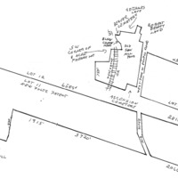
The Payne estate in 1915
Item
Description
Williamson W and Annie M Fuller to Oliver H Payne
THIS INDENTURE Made this fifth day of January in the year nineteen hundred and nine,
BETWEEN WILLIAMSON W. FULLER and ANNIE M. FULLER his wife, of the City County and State of New York, parties of the first part, and
OLIVER H. PAYNE of the City County and State of New York party, of the second part,
WITNESSETH: That the said parties of the first part for and in consideration of One Dollar ($1.00) and other valuable consideration lawful money of the United States, paid by the said party of the second part do hereby remise, release and forever quit-claim unto the said party of the second part, his heirs and assigns forever,
ALL THAT CERTAIN tract of land with the buildings thereon erected situate lying and being at Esopus, Ulster County in the Stale of New York, being a portion of lot number eleven (11) of the three mile or river lots in the north division of the Patent of New Paltz lying and situate in the Township of Esopus, County of Ulster and State of New York, which said tract of land is bounded and contains as follows;
Beginning on the Hudson River at a pitch pine tree on the division line between lots numbers eleven and twelve (12) in said patent, thence running along said division line north seventy four (74) degrees west forty two (42) chains sixty eight (68) link to the center of the public highway leading from Newburgh to Kingston, thence (2) along said highway south four (4) degrees east thirteen (13) chains more or less to the entrance gate thence (3) still along said highway south twenty seven (27) degrees east thirteen (13) chains and fifty five (55) links more or less to the south line of the said tract, thence (4) along said line as the fence now stands south seventy two (72) degrees east thirty one (31) chains and thirty (30) links to the Hudson River thence (5) along said river in a northerly direction about twenty four (24) chains to the place of beginning., Containing as surveyed by Mark W. Powell in December 1851 eighty (80) acres and sixtenths (6/10) of an acre be the said several dimensions or contents more or less. Being the same premises conveyed to said Adam Neidlinger by Alexander Holland end wife by deed dated the 20th day of May 1884, and recorded in the Clerk's Office of the County of Ulster on the 22nd day of May 1884, in Book 251 of Deeds page 359.
And also all the right title interest, estate and advantages which the said Alexander Holland and wife have acquired and now have or might hereafter have by virtue of a certain Act of the legislature of the State of New York entitled "An act to Authorize Archibald Russell to erect a dock or wharf in the Hudson River in the Town of Esopus adjoining his lands passed May 14, 1845, and all other riparian rights of said parties hereto of the first part
And also all that certain tract, piece or parcel of land situate lying and being in the town of Esopus, County of Ulster and State of New York bounded and described as follows:-
Beginning at a point in the highway leading from Newburgh to Kingston where the division line between lot eleven (11) and lot twelve (12) of the three mile or river lots in the north division of the New Paltz crosses said highway at or near the southerly boundary of a cemetery running thence along said line north 71 30' west six thousand five hundred and, eighty nine (6589) feet more or less thence south 45 west six hundred and sixty four (654) feet more or less thence south 17' 15' west seven hundred and fifty two (752) feet to the highway known as the West Park Road
thence in a south easterly direction along said highway as it winds and turns to a stake and stones, being the corner of land now or late of M. W. Powell, thence north 13 3/4' east four hundred (400) feet, thence north 12' east four hundred (440) feet, thence north 5 1/2' seat two hundred (200) feet thence north 14 30' east two hundred and thirty (230) feet, thence south 69' 30' east nineteen hundred and fifteen (1915) feet to the end of stone wall thence south 70 10' east three thousand seven hundred and twenty (3720) feet to said highway leading from Newburgh to Kingston and thence northerly along said highway as it winds and turns,, seventeen hundred and fifty three (1753) feet, to the point or piece of beginning. Excepting therefrom the land conveyed by Helen R. Russell to the New York West Shore and Buffalo Railway Company by deed dated November 16th, 1881, and recorded in the office of the Clerk of Ulster County in Book of Deeds Number 232, at page 160, etc. Containing after deducting the lands of said Railway Company two hundred and sixteen 19/100 acres be the same more or less.
Being the tract or parcel of land thirdly described in and conveyed by a certain dead bearing date the seventh day of December in the year 1885, made and executed by Helen R. Russell to Cynthia Helen Durkee the wife of Eugene R. Durkee and recorded in the office of, the Clerk of the County of Ulster on the eighth day of December in the year 1885 in Book 260 of Deeds at page 612, and a part of the real estate ff which the said Cynthia Helen Durkee died seized and which by her last will and testament bearing date May 22, 1874, and duly proved and admitted to probate in and by the Surrogate's Court of the County of Ulster on the l0th day of June in the year 1890 was by her devised to her husband, the said Eugene R. Durkee. It being understood that the courses given in the foregoing description are taken from surveys made by A. Grant Childs, November 1885.
And all right title and interest of the parties hereto of the first part to one half in width of the roads or highways lying opposite and adjacent to said premises. Being the same premises conveyed to said Adam Neidlinger by Eugene R. Durkee by deed dated August 13th, 1890, and recorded in the Clerk's Office of Ulster County on the 18th day of August, 1890 in Book 293 of Deeds page 629.
And also all that certain point of a gravel hill lying in said Town of Esopus on the southwest side of the Hyde Park and Dashville Road, being bounded as follows:-
Beginning at a stone set in the ground on the top of said hill and running south six degrees west one chain and seventy five links to the west side of said road. Thence along the west and south sides of said road about three chains and fifty links to the end of a stone wall, thence south ten degrees east one chain and fifty seven links to the place of beginning. Containing one tenth of an acre, subject to the condition that gravel shall not be removed from so close to the line as not to leave as much gravel for the use of the road as the present survey of the road now covers and yet not undermine a fence or wall set upon said line across the gravel hill, and also subject to the reservations of the privilege of drawing a few loads reserved to Elias Terpening if he should want to use it about his house or otherwise.
Being the same premises conveyed to said Adam Neidlinger by Eugene R. Durkee by deed dated the 13th day of August 1890 and recorded in Ulster County Clerk's Office on the 18th day or August, l890 in Liber 293 of Deeds gage 628. The property herein conveyed being the same property granted to said Williamson W. Fuller by Louise Neidlinger, George F. Neidlinger and Rudolf G. Neidlinger as Executrix and Executors of and Trustees under the last will and testament or Adam Neidlinger, late of West Park, Ulster County New York deceased, by deed dated the 29th day of December, in the year one thousand nine hundred and eight, and by Louise Neidlinger, widow of Adam Neidlinger, deceased, and Elizabeth Weber, George P. Neidlinger, unmarried, Emma Louise Von Bernuth, Henry T. Neidlinger, and Emily Neidlinger, his wife, and Rudolf G. Neidlinger unmarried, Children and heirs at law of said Adam Neidlinger, deceased by deed dated the 28th. day of December, in the year nineteen hundred and eight,
.
TOGETHER WITH THE APPURTENANCES all the estate and rights of the parties of the first part in and to said premises.
TO HAVE AND TO HOLD The above mentioned and described premises unto the said party of the second part, his heirs and assigns forever.
IN WITNESS WHEREOF The said parties of the first part have hereunto set their hands and seals the day and year first above written.
In presence of.
R. J. Boylan Williamson W. Fuller Seal
Annie M. Fuller Seal
STATE OF NEW YORK
COUNTY OF NEW YORK : SS.
On this 7th day of January in the year one thousand nine hundred and nine, before me, the undersigned, personally came and appeared WILLIAMSON W. FULLER AND ANNIE M. FULLER his wife, to me known and known to me to be the same persons described in and who executed the foregoing Instrument, and severally acknowledged to me the: they executed the same for the uses and purposes therein mentioned.
Seal R. J. Boylan, .
Notary Public, No. 302,
Kings County, N. Y. Registers Certificate
No. 2025, Certificate filed in New York
County N. Y. My commission expires
March 20, 1909.
STATE OF NEW YORK :
COUNTY OF NEW YORK: SS.
I, PETER J. DOOLING, Clerk of the County of New York, and also Clerk of the Supreme Court for the said County, the same being a Court of Record, Do Hereby Certify that R. J. BOYLAN whose name is subscribed to the Certificate of the proof or acknowledgment of the annexed instrument, arid thereon written, was at the time of taking such proof or acknowledgment, a Notary Public in and for the County of New York, dwelling in the said County, commissioned and sworn, and duly authorized to take the name. And further that I am well acquainted with the handwriting of such Notary, and verily believe that the signature to the said certificate of proof or acknowledgment Is genuine.
IN TESTIMONY WHEREOF, I have hereunto set my hand and affixed the seal of the said Court and County
. Peter J Dooling, Seal.
Clerk
this is a transcription of a deed located in the Ulster County Clerk's Vault Room, Kingston, New York
________________________________________________________________
Williamson and Annie Fuller to Oliver H Payne
THIS INDENTURE, made the 28th day of October, in the year nineteen hundred and nine.
BETWEEN WILLIAMSON W. FULLER and ANNIE M. FULLER, his wife, of the City, County and State of New York, parties of the first part, and
OLIVER H. PAYNE, of the City. County and State of New York, party of the second part.
WITNESSETH. That the said parties of the first part, in consideration of one dollar and other valuable consideration, lawful money of the United States, paid by the party of the second part, do hereby remise, release and forever quit-claim and convey unto the party of the second part, his heirs and assigns forever,
ALL THAT CERTAIN tract or parcel of land, situate in the town of Esopus, Ulster County, N. Y. beginning at a point on the westerly side of the Hudson River, at the northeasterly corner of land now owned by 0. H. Payne (by deed of W. W. Fuller dated January 5. 1909) and running from thence by survey of May, 1909. north 70 degrees 37 minutes west 2823 5/10 feet to a point in the center of the highway leading from West Park to Esopus, thence north 50 minutes west along the center of said highway, 282 feet to a point, thence north 83 degrees 10 minutes west passing along the northerly side of a cemetery, 381 feet to the northwesterly corner of said cemetery, thence south 23 degrees 40 minutes west 104 feet, thence south 17 degrees 50 minutes west 68 feet, thence south 1 degree 35 minutes west 24 feet to a point in the westerly line of said cemetery, thence north 71 degrees west crossing Black Creek. and the N. Y. S. & B. Railway; and continuing along the northerly line of said Payne's (formerly Fuller's) land 1307 feet to a stone heap by a wall, thence north 2 degrees 20 minutes east along the edge of the timber, 750 feet to an old stone heap; thence south 83 degrees 57 minutes east along a row of marked trees 617 feet to an old stone, monument, thence north 13 degrees 25 minutes east along a row of marked trees, 484 feet. to a stake and stones at the southwesterly corner of what is termed the eight acre factory lot; thence south 89 degrees 45 minutes east crossing the above mentioned railway 375 5/10 feet to a point; thence north 5 degrees west along what was originally the Saw Mill pond 81 5/10 feet to a point, thence north 24 degrees 10 minutes east 52 2/10 feet to a point, thence north 47 degrees 15 minutes east 39 5/10 feet to a point, thence north 72 degrees 15 minutes east continuing along the outline of the old saw mill pond and crossing the creek, 149 feet to a point in the center of the above mentioned highway, thence north 17 degrees 15 minutes west 241 5/10 feet to a point; thence north 2. degrees west 100 feet to a point in the center of the highway; thence north 11 degrees east 100 feet, to a point in the center of tie highway. thence south 84 degrees 55 minutes east leaving the highway and passing along the southerly side of another cemetery 90 feet to the southeasterly corner thereof, thence north 8 degrees 10 minutes east along the easterly side of the last mentioned cemetery, 117 feet to a point in the easterly line thereof; thence south 76 degrees 10 minutes east along the southerly line of lands formerly of A. D. James, 85 feet to a point; thence south 80 degrees 10 minutes east 187 feet to a point, thence south 78 degrees 40 minutes east 229 feet to a point, thence south 74 degrees 50 minutes east 89 feet to a point, the southeasterly corner of said James' lands; thence along the east line of said James land north 20 degrees 35 minutes east 319 feet, to the south line of lands of Robert Beatty, thence along the lands of said Beatty the following courses and distances south 42 degrees 15 minutes east 66 feet, south 82 degrees,15 minutes east 89 foot to a corner, south 23 degrees 45 minutes west 254 feet to a corner, south 76 degrees 15 minutes east crossing a creek, 112 feet to a corner, south 26 degrees 45 minutes west on the east side of said creek. 284 feet to a corner south 73 degrees 15 minutes east 197 feet to a corner, south 7 degrees 45 minutes west 283 feet to a corner. south 70 degrees east 2514 foot to the Hudson River, thence southerly along the west side of said river 1822 feet to the place of beginning.
Excepting and reserving from the above described premises the right of way, tract or parcel of land heretofore conveyed to or acquired by the New York, West Shore and Buffalo Railway Company. Containing exclusive of said Railway Company's land, 179 635/1000 acres of land, and being the same premises conveyed by Anna T. Pratt and Elizabeth Comtesse de Gasquet James to Williamson W. Fuller, by deed dated August 12, 1909, and recorded in the Ulster County Clerk's office, September 18. 1909.
TOGETHER with the appurtenances, and all the estate and rights of the parties of the first part in and to said premises.
T0 HAVE AND TO HOLD the above mentioned and described premises unto the party of the second part, his heirs and assigns forever.
IN WITNESS whereof, the said parties of the first part have hereunto set their hands and seals the day and year first above written.
In presence of,
R. J. Boylan Williamson W. Fuller, (seal)
Annie M. Fuller. (seal)
STATE OF NEW YORK
COUNTY OF NEW YORK: SS.:
0n this 28th day of October, 1909, before me, the undersigned, personally came and appeared WILLIAMSON W. FULLER and ANNIE M. FULLER, his wife to me known and known to me to be the individuals described in and who executed the foregoing instrument, and severally acknowledged to me that they executed the same
R. J. Boylan
Notary Public No. 286, Kings County N. Y
Register's certificate no. 2025
Certificate filed in New York County, N.Y., No. 1251
My Commission expires March 30, 1911
STATE OF NEW YORK
COUNTY OF NEW YORK: ss.:
I, PETER J. DOOLING, Clerk of the County of New York, and also Clerk of the Supreme Courty for the said County, the same being a court of Record, Do hereby Certify that
R. J. BOYLAN
has filed in the Clerk's office of the County of New York, a certified copy of his appointment and qualification as Notary Public, for the County of Kings, with his autograph signature, and was at the time of taking the proof or acknowledgment, of the annexed instrument, duly authorized to take the same. And further that I am well acquainted with the the handwriting of such Notary, and believe the signature to the said certificate of proof or acknowledgment to be genuine.
IN TESTIMONY WHEREOF, I have hereunto set my hand and affixed the seal of the said Court and County, the 28 day of Oct., 1909.
Peter J. Dooling,
Clerk
A true record entered
Nov. 1, 1909, at 9:25 A. M.
this is a transcription of a deed located in the Ulster County Clerk's Vault Room, Kingston, New York
Type
Map