Items
-
-
-
-
-
-
-
-
-
-
-
The Historical Growth and Development of the Marist Brothers in the United States: Poughkeepsie Area
-
-
-
-
-
-
-
-
-
-
-
-
-
-
-
-
-
-
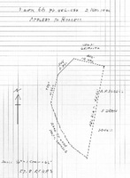
The Payne estate in 1915
Williamson W and Annie M Fuller to Oliver H Payne THIS INDENTURE Made this fifth day of January in the year nineteen hundred and nine, BETWEEN WILLIAMSON W. FULLER and ANNIE M. FULLER his wife, of the City County and State of New York, parties of the first part, and OLIVER H. PAYNE of the City County and State of New York party, of the second part, WITNESSETH: That the said parties of the first part for and in consideration of One Dollar ($1.00) and other valuable consideration lawful money of the United States, paid by the said party of the second part do hereby remise, release and forever quit-claim unto the said party of the second part, his heirs and assigns forever, ALL THAT CERTAIN tract of land with the buildings thereon erected situate lying and being at Esopus, Ulster County in the Stale of New York, being a portion of lot number eleven (11) of the three mile or river lots in the north division of the Patent of New Paltz lying and situate in the Township of Esopus, County of Ulster and State of New York, which said tract of land is bounded and contains as follows; Beginning on the Hudson River at a pitch pine tree on the division line between lots numbers eleven and twelve (12) in said patent, thence running along said division line north seventy four (74) degrees west forty two (42) chains sixty eight (68) link to the center of the public highway leading from Newburgh to Kingston, thence (2) along said highway south four (4) degrees east thirteen (13) chains more or less to the entrance gate thence (3) still along said highway south twenty seven (27) degrees east thirteen (13) chains and fifty five (55) links more or less to the south line of the said tract, thence (4) along said line as the fence now stands south seventy two (72) degrees east thirty one (31) chains and thirty (30) links to the Hudson River thence (5) along said river in a northerly direction about twenty four (24) chains to the place of beginning., Containing as surveyed by Mark W. Powell in December 1851 eighty (80) acres and sixtenths (6/10) of an acre be the said several dimensions or contents more or less. Being the same premises conveyed to said Adam Neidlinger by Alexander Holland end wife by deed dated the 20th day of May 1884, and recorded in the Clerk's Office of the County of Ulster on the 22nd day of May 1884, in Book 251 of Deeds page 359. And also all the right title interest, estate and advantages which the said Alexander Holland and wife have acquired and now have or might hereafter have by virtue of a certain Act of the legislature of the State of New York entitled "An act to Authorize Archibald Russell to erect a dock or wharf in the Hudson River in the Town of Esopus adjoining his lands passed May 14, 1845, and all other riparian rights of said parties hereto of the first part And also all that certain tract, piece or parcel of land situate lying and being in the town of Esopus, County of Ulster and State of New York bounded and described as follows:- Beginning at a point in the highway leading from Newburgh to Kingston where the division line between lot eleven (11) and lot twelve (12) of the three mile or river lots in the north division of the New Paltz crosses said highway at or near the southerly boundary of a cemetery running thence along said line north 71 30' west six thousand five hundred and, eighty nine (6589) feet more or less thence south 45 west six hundred and sixty four (654) feet more or less thence south 17' 15' west seven hundred and fifty two (752) feet to the highway known as the West Park Road thence in a south easterly direction along said highway as it winds and turns to a stake and stones, being the corner of land now or late of M. W. Powell, thence north 13 3/4' east four hundred (400) feet, thence north 12' east four hundred (440) feet, thence north 5 1/2' seat two hundred (200) feet thence north 14 30' east two hundred and thirty (230) feet, thence south 69' 30' east nineteen hundred and fifteen (1915) feet to the end of stone wall thence south 70 10' east three thousand seven hundred and twenty (3720) feet to said highway leading from Newburgh to Kingston and thence northerly along said highway as it winds and turns,, seventeen hundred and fifty three (1753) feet, to the point or piece of beginning. Excepting therefrom the land conveyed by Helen R. Russell to the New York West Shore and Buffalo Railway Company by deed dated November 16th, 1881, and recorded in the office of the Clerk of Ulster County in Book of Deeds Number 232, at page 160, etc. Containing after deducting the lands of said Railway Company two hundred and sixteen 19/100 acres be the same more or less. Being the tract or parcel of land thirdly described in and conveyed by a certain dead bearing date the seventh day of December in the year 1885, made and executed by Helen R. Russell to Cynthia Helen Durkee the wife of Eugene R. Durkee and recorded in the office of, the Clerk of the County of Ulster on the eighth day of December in the year 1885 in Book 260 of Deeds at page 612, and a part of the real estate ff which the said Cynthia Helen Durkee died seized and which by her last will and testament bearing date May 22, 1874, and duly proved and admitted to probate in and by the Surrogate's Court of the County of Ulster on the l0th day of June in the year 1890 was by her devised to her husband, the said Eugene R. Durkee. It being understood that the courses given in the foregoing description are taken from surveys made by A. Grant Childs, November 1885. And all right title and interest of the parties hereto of the first part to one half in width of the roads or highways lying opposite and adjacent to said premises. Being the same premises conveyed to said Adam Neidlinger by Eugene R. Durkee by deed dated August 13th, 1890, and recorded in the Clerk's Office of Ulster County on the 18th day of August, 1890 in Book 293 of Deeds page 629. And also all that certain point of a gravel hill lying in said Town of Esopus on the southwest side of the Hyde Park and Dashville Road, being bounded as follows:- Beginning at a stone set in the ground on the top of said hill and running south six degrees west one chain and seventy five links to the west side of said road. Thence along the west and south sides of said road about three chains and fifty links to the end of a stone wall, thence south ten degrees east one chain and fifty seven links to the place of beginning. Containing one tenth of an acre, subject to the condition that gravel shall not be removed from so close to the line as not to leave as much gravel for the use of the road as the present survey of the road now covers and yet not undermine a fence or wall set upon said line across the gravel hill, and also subject to the reservations of the privilege of drawing a few loads reserved to Elias Terpening if he should want to use it about his house or otherwise. Being the same premises conveyed to said Adam Neidlinger by Eugene R. Durkee by deed dated the 13th day of August 1890 and recorded in Ulster County Clerk's Office on the 18th day or August, l890 in Liber 293 of Deeds gage 628. The property herein conveyed being the same property granted to said Williamson W. Fuller by Louise Neidlinger, George F. Neidlinger and Rudolf G. Neidlinger as Executrix and Executors of and Trustees under the last will and testament or Adam Neidlinger, late of West Park, Ulster County New York deceased, by deed dated the 29th day of December, in the year one thousand nine hundred and eight, and by Louise Neidlinger, widow of Adam Neidlinger, deceased, and Elizabeth Weber, George P. Neidlinger, unmarried, Emma Louise Von Bernuth, Henry T. Neidlinger, and Emily Neidlinger, his wife, and Rudolf G. Neidlinger unmarried, Children and heirs at law of said Adam Neidlinger, deceased by deed dated the 28th. day of December, in the year nineteen hundred and eight, . TOGETHER WITH THE APPURTENANCES all the estate and rights of the parties of the first part in and to said premises. TO HAVE AND TO HOLD The above mentioned and described premises unto the said party of the second part, his heirs and assigns forever. IN WITNESS WHEREOF The said parties of the first part have hereunto set their hands and seals the day and year first above written. In presence of. R. J. Boylan Williamson W. Fuller Seal Annie M. Fuller Seal STATE OF NEW YORK COUNTY OF NEW YORK : SS. On this 7th day of January in the year one thousand nine hundred and nine, before me, the undersigned, personally came and appeared WILLIAMSON W. FULLER AND ANNIE M. FULLER his wife, to me known and known to me to be the same persons described in and who executed the foregoing Instrument, and severally acknowledged to me the: they executed the same for the uses and purposes therein mentioned. Seal R. J. Boylan, . Notary Public, No. 302, Kings County, N. Y. Registers Certificate No. 2025, Certificate filed in New York County N. Y. My commission expires March 20, 1909. STATE OF NEW YORK : COUNTY OF NEW YORK: SS. I, PETER J. DOOLING, Clerk of the County of New York, and also Clerk of the Supreme Court for the said County, the same being a Court of Record, Do Hereby Certify that R. J. BOYLAN whose name is subscribed to the Certificate of the proof or acknowledgment of the annexed instrument, arid thereon written, was at the time of taking such proof or acknowledgment, a Notary Public in and for the County of New York, dwelling in the said County, commissioned and sworn, and duly authorized to take the name. And further that I am well acquainted with the handwriting of such Notary, and verily believe that the signature to the said certificate of proof or acknowledgment Is genuine. IN TESTIMONY WHEREOF, I have hereunto set my hand and affixed the seal of the said Court and County . Peter J Dooling, Seal. Clerk this is a transcription of a deed located in the Ulster County Clerk's Vault Room, Kingston, New York ________________________________________________________________ Williamson and Annie Fuller to Oliver H Payne THIS INDENTURE, made the 28th day of October, in the year nineteen hundred and nine. BETWEEN WILLIAMSON W. FULLER and ANNIE M. FULLER, his wife, of the City, County and State of New York, parties of the first part, and OLIVER H. PAYNE, of the City. County and State of New York, party of the second part. WITNESSETH. That the said parties of the first part, in consideration of one dollar and other valuable consideration, lawful money of the United States, paid by the party of the second part, do hereby remise, release and forever quit-claim and convey unto the party of the second part, his heirs and assigns forever, ALL THAT CERTAIN tract or parcel of land, situate in the town of Esopus, Ulster County, N. Y. beginning at a point on the westerly side of the Hudson River, at the northeasterly corner of land now owned by 0. H. Payne (by deed of W. W. Fuller dated January 5. 1909) and running from thence by survey of May, 1909. north 70 degrees 37 minutes west 2823 5/10 feet to a point in the center of the highway leading from West Park to Esopus, thence north 50 minutes west along the center of said highway, 282 feet to a point, thence north 83 degrees 10 minutes west passing along the northerly side of a cemetery, 381 feet to the northwesterly corner of said cemetery, thence south 23 degrees 40 minutes west 104 feet, thence south 17 degrees 50 minutes west 68 feet, thence south 1 degree 35 minutes west 24 feet to a point in the westerly line of said cemetery, thence north 71 degrees west crossing Black Creek. and the N. Y. S. & B. Railway; and continuing along the northerly line of said Payne's (formerly Fuller's) land 1307 feet to a stone heap by a wall, thence north 2 degrees 20 minutes east along the edge of the timber, 750 feet to an old stone heap; thence south 83 degrees 57 minutes east along a row of marked trees 617 feet to an old stone, monument, thence north 13 degrees 25 minutes east along a row of marked trees, 484 feet. to a stake and stones at the southwesterly corner of what is termed the eight acre factory lot; thence south 89 degrees 45 minutes east crossing the above mentioned railway 375 5/10 feet to a point; thence north 5 degrees west along what was originally the Saw Mill pond 81 5/10 feet to a point, thence north 24 degrees 10 minutes east 52 2/10 feet to a point, thence north 47 degrees 15 minutes east 39 5/10 feet to a point, thence north 72 degrees 15 minutes east continuing along the outline of the old saw mill pond and crossing the creek, 149 feet to a point in the center of the above mentioned highway, thence north 17 degrees 15 minutes west 241 5/10 feet to a point; thence north 2. degrees west 100 feet to a point in the center of the highway; thence north 11 degrees east 100 feet, to a point in the center of tie highway. thence south 84 degrees 55 minutes east leaving the highway and passing along the southerly side of another cemetery 90 feet to the southeasterly corner thereof, thence north 8 degrees 10 minutes east along the easterly side of the last mentioned cemetery, 117 feet to a point in the easterly line thereof; thence south 76 degrees 10 minutes east along the southerly line of lands formerly of A. D. James, 85 feet to a point; thence south 80 degrees 10 minutes east 187 feet to a point, thence south 78 degrees 40 minutes east 229 feet to a point, thence south 74 degrees 50 minutes east 89 feet to a point, the southeasterly corner of said James' lands; thence along the east line of said James land north 20 degrees 35 minutes east 319 feet, to the south line of lands of Robert Beatty, thence along the lands of said Beatty the following courses and distances south 42 degrees 15 minutes east 66 feet, south 82 degrees,15 minutes east 89 foot to a corner, south 23 degrees 45 minutes west 254 feet to a corner, south 76 degrees 15 minutes east crossing a creek, 112 feet to a corner, south 26 degrees 45 minutes west on the east side of said creek. 284 feet to a corner south 73 degrees 15 minutes east 197 feet to a corner, south 7 degrees 45 minutes west 283 feet to a corner. south 70 degrees east 2514 foot to the Hudson River, thence southerly along the west side of said river 1822 feet to the place of beginning. Excepting and reserving from the above described premises the right of way, tract or parcel of land heretofore conveyed to or acquired by the New York, West Shore and Buffalo Railway Company. Containing exclusive of said Railway Company's land, 179 635/1000 acres of land, and being the same premises conveyed by Anna T. Pratt and Elizabeth Comtesse de Gasquet James to Williamson W. Fuller, by deed dated August 12, 1909, and recorded in the Ulster County Clerk's office, September 18. 1909. TOGETHER with the appurtenances, and all the estate and rights of the parties of the first part in and to said premises. T0 HAVE AND TO HOLD the above mentioned and described premises unto the party of the second part, his heirs and assigns forever. IN WITNESS whereof, the said parties of the first part have hereunto set their hands and seals the day and year first above written. In presence of, R. J. Boylan Williamson W. Fuller, (seal) Annie M. Fuller. (seal) STATE OF NEW YORK COUNTY OF NEW YORK: SS.: 0n this 28th day of October, 1909, before me, the undersigned, personally came and appeared WILLIAMSON W. FULLER and ANNIE M. FULLER, his wife to me known and known to me to be the individuals described in and who executed the foregoing instrument, and severally acknowledged to me that they executed the same R. J. Boylan Notary Public No. 286, Kings County N. Y Register's certificate no. 2025 Certificate filed in New York County, N.Y., No. 1251 My Commission expires March 30, 1911 STATE OF NEW YORK COUNTY OF NEW YORK: ss.: I, PETER J. DOOLING, Clerk of the County of New York, and also Clerk of the Supreme Courty for the said County, the same being a court of Record, Do hereby Certify that R. J. BOYLAN has filed in the Clerk's office of the County of New York, a certified copy of his appointment and qualification as Notary Public, for the County of Kings, with his autograph signature, and was at the time of taking the proof or acknowledgment, of the annexed instrument, duly authorized to take the same. And further that I am well acquainted with the the handwriting of such Notary, and believe the signature to the said certificate of proof or acknowledgment to be genuine. IN TESTIMONY WHEREOF, I have hereunto set my hand and affixed the seal of the said Court and County, the 28 day of Oct., 1909. Peter J. Dooling, Clerk A true record entered Nov. 1, 1909, at 9:25 A. M. this is a transcription of a deed located in the Ulster County Clerk's Vault Room, Kingston, New York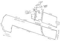
-
-
-
-
-
-
Topographic Map of the Esopus Property
Topographic Map of the Esopus Property This is the 1997 topographic map labeled "Hyde Park - NY" published by the U.S. Department of the Interior as part of the U.S. Geological Survey series ("USGS") The map was compiled in 1962, but updated with aerial surveys in 1978 and 1997. Descriptions of the details of the map are in the section below this map Details relevant to the Marist Brothers' Property. Contour lines link land of the same elevation above sea level. When lines are close together, it signifies steep slopes. Lines far apart show gentle rises or fell in the terrain. Note the close lines as the railroad passes through the Payne properties west of route 9W. Note that the lines are close together near the river. The heavy red line is the main highway, route 9W. The line with alternate red and white (or empty) sections is Black Creek Road. The broken red line is also used for Floyd Ackert Road. The broken red line indicates a secondary road. Names on the map date to 1962. Some translations: Betty (along the river) is a geodesic marker inserted in the main dock during the original survey of the Hudson River. Copper (along the river) is a geodesic marker inserted near the pump house at the north end of the Payne estate. Santa Maria Novitiate is the property once owned by Archibald Russell and now belonging to the Irish Christian Brothers. Marist Brothers Seminary is what we called the "mansion" or "main house" now owned privately. Marist Preparatory Sch is what we mistakenly called the "English Village" now owned by the Marist Brothers. One black dot represents the Pratt Cottage now called Holy Rosary, and another dot represents the Ice House. Wiltwyck School are the original Payne employee cottages calle3d "English Village" on Carrère & Hastings plans. . The Payne chicken buildings and farm superintendent's cottage is not identified, but is marked directly south of the caption Ascension Church Cem and due west of Marist Brothers Seminary. Light green areas marked with what look like tufts of grass represent swamps. The Payne property encountered steeps slopes just west of route 9-W, the crossed swampland until it reached what is now Floyd Ackert Road. John Burroughs' house Slabsides simple a black rectangle SW of the caption "Sand and Gravel Pit" and due south of the altitude marker "544" feet. Burroughs also purchased the swamps SSW of Slabsides. Mount Saint Alphonsus Seminary was built on Robert Livingston Pell's Pelham Farm, which extended southwards to the Black Creek.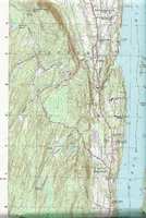
-
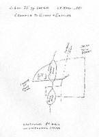
west side -- tract C (near West Park Road--now Floyd Ackert Road)
THIS INDENTURE, made the 2nd day of May, nineteen hundred and sixty-seven, between WILTWICK SCHOOL FOR BOYS, INC., a New York membership corporation having its principal office at 260 Park Avenue South, New York, N.Y., party of the first part, and WALRUS, INC., a New York corporation having its principal place of business at 254 Fair Street, Kingston, New York, party of the second part, WITNESSETH, that the party of the first part, in consideration of Ten ($10.00) dollars, lawful money of the United States, paid by the party of the second part, does hereby grant and release unto the party of the second part, the heirs, or successors and assigns of the party of the second part forever, ALL that certain plot, piece or parcel of land, with the buildings and improvements thereon erected, situate, lying and being in the Town of Esopus, County of Ulster and State of New York, more particularly described in Schedule A annexed hereto and hereby made a part hereof. TOGETHER with the right of the Grantor, if any, to cross the right-of-way of the New York Central Railroad Company adjacent to a portion of the premises. TOGETHER with all right, title and interest, if any, of the party of the first part in and to any streets and roads abutting the above described premises to the center lines thereof, TOGETHER with the appurtenances and all the estate and rights of the party of the first part in and to said premises, TO HAVE AND TO HOLD the premises herein granted unto the party of the second part, the heirs or successors and assigns of the party of the second part forever. AND the party of the first part, in compliance with section 13 of the Lien Law, covenants that the party of the first part will receive the consideration for this conveyance and will hold the right to receive such consideration as a trust fund to be applied first for the purpose of paying the cost of the improvement and will apply the same first to the payment of the cost of the improvement before using any part of the total of the same for any other purpose. The word "party" shall be construed as if it read "parties" whenever the sense of this indenture so requires. IN WITNESS WHEREOF, the party of the first part has duly executed this deed the day and year first above written. WILTWYCK SCHOOL FOR BOYS, INC. By Carl M. Spero, Treasurer STATE OF NEW YORK, COUNTY OF NEW YORK On the 2nd day of May, 1967, before me personally came Carl M. Spero to me known, who, being by me duly sworn, did depose and say that he resides at No. 139 East 94th Street, New York, N.Y., that he is the Treasurer of Wiltwyck School for Boys, Inc., the corporation described in and which executed the foregoing instrument; that he knows the seal of said corporation; that the seal affixed to said instrument is such corporate seal; that it was so affixed by order of the board of directors of said corporation, and that he signed his name thereto by like order. Joseph E. Browdy Notary Public, State of New York No. 31-5468875 Qualified in New York County Commission Expires March 30, 1968 Filed 2:06 PM, May 17, 1967 Albert Spada, Ulster County Clerk Schedule A ALL THAT PLOT OF LAND with the Buildings thereon situate in the Town of Esopus, County of Ulster end State of New York. bounded and described as follows: BEGINNING at a point in the. northerly line of said land now or formerly of Dr. Gordon distant as measured along, same north sixty-five degrees fifty-two minutes forty seconds west one hundred and twelve and seventy-five one-hundredths feet; north sixty-seven degrees twenty-one minutes thirty seconds west three hundred and seventy-six and ninety-nine one-hundredths feet; north sixty-six degrees forty-five minutes twenty seconds west seven hundred and forty and thirty one-hundredths feet and north sixty-six degrees fifty-five minutes fifty seconds west two hundred and thirty-seven and twenty-nine one-hundredths feet, and north sixty-six degrees fifty-five minutes fifty seconds west one hundred eighteen and thirty-eight one-hundredths feet from the westerly side of the State Highway leading from Highland to Kingston, known as Route 9-W being also the westerly line of lands of the New York Central Railroad Company, known as the West Shore Railroad, north sixty-seven degrees sixteen minutes no seconds west three hundred and sixty-three and two one-hundredths feet; north sixty-six degrees forty-six minutes forty seconds west two hundred and seventy-nine and thirty-seven one-hundredths feet; north sixty-seven degrees forty-five minutes thirty seconds west one hundred and nine and forty-three one-hundredths feet; north sixty-seven degrees thirty-six minutes twenty seconds west one hundred and four and eighteen one-hundredths feet; north sixty-six degrees thirty-seven minutes fifty seconds west one hundred and seventeen and fifteen one-hundredths feet; north sixty-six degrees eleven minutes fifty seconds west one hundred and seventy-three and seven one-hundredths feet; north sixty-seven degrees eight minutes fifty seconds west three hundred and twenty-three and eighty-eight one-hundredths feet; north sixty-six degrees thirty-nine minutes thirty seconds west one thousand one hundred and fifty-six and sixty-five one-hundredths feet; north sixty-seven degrees twenty-one minutes fifty seconds west one hundred and ninety-eight and forty-nine one-hundredths feet; north sixty-six degrees forty-five minutes no seconds west five hundred and three and ninety-six one-hundredths feet; north sixty-seven degrees forty-six minutes thirty seconds west one hundred and twenty-nine and fifty-seven one-hundredths feet; north sixty-five degrees fifty-seven minutes forty seconds west one hundred arid eighty-nine and eighty-five one-hundredths feet, and north sixty-seven degrees fifty minutes fifty seconds west two hundred and sixty-nine and seventy-four one hundredths feet to the northwest corner of said land now or formerly of Dr:. Gordon; thence running along the westerly line of. said last mentioned. the following courses and distances: south sixteen degrees ten minutes forty seconds west two-hundred and thirty and sixty-four one-hundredths feet; south twelve degrees fifty-nine minutes no seconds west two hundred and eighty-seven and four, one-hundredths feet; south fifteen degrees thirty-one minutes fifty seconds west .two hundred and ninety-six and twenty-five one-hundredths feet and south seventeen degrees no minutes ten seconds west four hundred and forty-one and thirty-three one -hundredths feet to the northerly side of the highway known as West Park Road; thence running along the northerly side of said highway known as West Park Road, north sixty-three degrees forty-eight minutes fifty seconds west four hundred and ninety-three and sixty-nine one-hundredths feet to the center line of said. highway known as West Park Road, and thence running along said center line of West Park Road the following courses and distances: north forty-four degrees fifty-one minutes thirty seconds west seventy-seven and twenty-two one-hundredths feet; north twenty-five degrees fifty-five minutes twenty seconds west sixty-two and eighty-nine one-hundredths feet; north seven degrees fifty-six minutes ten seconds east fifty-eight and fifty-two one-hundredths feet; north twenty-four degrees seven minutes ten seconds east one hundred and thirty-two and sixty-eight one-hundredths feet; north five degrees thirty-six minutes fifty seconds east seventy-five and sixty-three one-hundredths feet; north forty-one degrees thirty-four minutes fifty seconds west sixty-nine and eighty-two one-hundredths feet; north fifty-six degrees nineteen minutes no seconds west two-hundred-and twenty-four and fifty-five one-hundredths feet; north thirty-three degrees fifteen minutes forty seconds west seventy-six and-fifty one-hundredths feet; north six degrees fifty minutes thirty seconds west seventy-nine and ninety-two one-hundredths feet; north twenty-five degrees thirty-eight minutes twenty seconds east one hundred and nineteen and seventeen one-hundredths feet; north five degrees sixteen minutes twenty seconds west one hundred .and five and thirty-six one-hundredths feet; north thirty degrees fifty-two minutes ten seconds west two hundred and forty-four and eighty-four one-hundredths feet and north eight degrees twenty-four minutes fifty seconds west two hundred and seventy-one and eight one-hundredths feet; thence leaving said center line of West Park Road and running north nine degrees forty-seven minutes no seconds east forty-five and seventy-two one-hundredths feet to the northeasterly side of West Park Road, and a corner of land now or formerly of Freer; thence running along the easterly line of said land of Freer north twenty degrees fourteen minutes no seconds east seven hundred and twenty-one and eighty-nine one-hundredths, feet and north fifty degrees forty-eight minutes fifty seconds east six hundred and sixty-three and twelve one-hundredths feet to the corner of two wire fences and the southerly line of land now or formerly of Kataski; thence running along the southerly line of said land of Kataski and part of the way along the center line of a stone wall the following courses and distances: south sixty-nine degrees twenty-three minutes twenty seconds east one hundred and eighty-three and eighty-five one-hundredths feet; south sixty-eight degrees fifty-one minutes twenty seconds east one hundred and ninety-two and ninety-four one-hundredths feet; south sixty-nine degrees twenty-two minutes twenty seconds east one hundred and thirty-one and eighty-four one-hundredths feet; south sixty-nine degrees twenty-three minutes thirty seconds east three hundred and sixteen and nineteen one-hundredths feet; south sixty-eight degrees twenty-five minutes no seconds east one hundred and and sixty-seven and twenty-seven one-hundredths feet; south sixty-nine degrees eight minutes no seconds east one hundred and seventy-six and twenty-seven one-hundredths feet; south sixty-six degrees forty-six minutes forty seconds east two hundred and twenty-nine and sixty-nine one-hundredths feet; south seventy-four degrees forty-five minutes fifty seconds east one hundred and forty-one and ninety-eight one-hundredths feet; south sixty-eight degrees thirty minutes forty seconds east four hundred and forty-two and thirty-six one-hundredths feet; south sixty-six degrees six minutes no seconds east thirty-eight and ninety-seven one-hundredths feet; south sixty-seven degrees forty-nine minutes ten seconds east one hundred and twenty-four and forty-two one-hundredths feet; south sixty-nine degrees twenty minutes forty seconds east three hundred and four and seventy-one one-hundredths feet; south sixty-nine degrees thirty-four minutes ten seconds east. four hundred and thirty-nine and eighty one-hundredths feet; south seventy degrees forty-four minutes fifty seconds east one hundred and sixty-six and thirteen one-hundredths feet; south sixty-seven degrees fifty-six minutes fifty seconds east ninety-nine and sixty-two one-hundredths feet; south sixty-seven degrees fifty- four minutes forty seconds east one hundred and eleven and seven one-hundredths feet; south sixty-nine degrees no minutes thirty seconds east one hundred and ninety and eight one-hundredths feet and south sixty-eight degrees forty-nine minutes twenty seconds east four hundred and forty-six and forty-one one-hundredths feet to the end of said stone wall and the southeast corner of said land now or formerly of Kataski thence running along the easterly line of said last mentioned land north ten degrees sixteen minutes no seconds west two hundred and four and five one-hundredths feet and north three degrees fifty-six minutes. forty seconds east five hundred and sixty-six and twenty-nine one-hundredths feet to a corner of two wire fences and land now or formerly of Henken; thence running along the southerly line of said land of Henken south eighty-four degrees one minute ten seconds east six hundred and seven and forty-five one-hundredths feet to another corner of said last mentioned land, and thence running along the easterly line of said land of Henken, north sixteen degrees thirteen minutes forty-seconds east sixty-six and thirty-one one-hundredths feet; north fifteen degrees fourteen minutes no seconds east one hundred and ninety-nine and eighty-four one-hundredths feet; north fourteen degrees forty-two minutes thirty seconds east one hundred and; two and thirty-six one-hundredths feet and north fifteen degrees twenty minutes twenty seconds east one hundred and twelve and fifty-eight one-hundredths feet to a corner of two wire fences at an angle point in said land now or formerly of Henken; thence still running along said last mentioned land south eighty-eight degrees twelve minutes forty seconds east ninety-one and six one-hundredths feet to the westerly line of land of the New York Central Railroad Company, formerly West Shore Railroad thence running the following courses and distances for the westerly line of said land of the New York Central Railroad Company: south seven degrees thirty-two minutes no seconds west three hundred and ninety-five and sixty-one one-hundredths feet, southerly on a curve to the right having a radius of two thousand eight hundred and fourteen and nine tenths feet a distance of five hundred and twenty-four and seventy one-hundredths feet ; south eighteen degrees thirteen minutes no seconds west eight hundred and eighty-three feet; southeasterly on a curve to the left having a radius of one thousand four hundred and eighty-two and seven tenths feet a distance of seven hundred and eleven and sixty-four one-hundredths feet and south nine degrees seventeen minutes no seconds east three hundred and ninety-three-and seventy-one one-hundredths feet to the northerly line of said land now or formerly of Dr. Gordon and thence running along the same south sixty-six degrees fifty-five minutes fifty seconds east one hundred and eighteen and thirty-eight one-hundredths feet, to the point of beginning. TOGETHER with the right of the Grantor, if any, to cross the right-of-way of the New York Central Railroad Company adjacent to a portion of the premises. THIS INDENTURE, Made the 5th day of November, Nineteen Hundred and Sixty-Eight Between Walrus, Inc., a corporation organized under the laws of the State of New York, with its principal place of business located at 254 Fair Street, Kingston, Ulster County, New YOrk, party of the first part, and PHILIP P. HELLRIEGEL AND JAMES R. SHIELDS, both of P. O. Box 92, Esopus, Ulster County, New York, as tenants in common, parties of the second part, WITNESSETH that the party of the first part, in consideration of TEN and 00/100 Dollar ($10.00) lawful money of the United States, and other good and valuable consideration paid by the parties of the second part, does hereby grant and release unto the parties of the second part, their distributees and assigns forever, PARCEL B ALL THAT PLOT OF LAND with the buildings thereon situate in the Town of Esopus, County of Ulster and State of New York, bounded and described as follows: Beginning at a point in the Northerly line of said land now or formerly of Dr. Gordon distant as measured along same North 65° 52' 40" West 112.75 feet; North 67° 21' 30" West 376.99 feet; North 66° 45' 20" West 740.30 feet and North 66° 55' 50" West 237.29 feet; and North 66° 55' 50" West 118.38 feet from the Westerly side of the State Highway leading from Highland to Kingston known as Route 9W being also the Westerly line of lands of the N.Y. Central Railroad Company, known as the West Shore Railroad, North 67° 16' 00" West 363.02 feet; North 66° 46' 40" West 279.37 feet; North 67° 45.' 30" West 109.43 feet; North 67° 36' 20" West 104.18 feet; North 66° 37' 50" West 117.15 feet; North 66° 11' 50" West 173.07 feet; North 67° 8' 50" West 323.88 feet; North 66° 39' 30" West 1156.65 feet; North 67° 21' 50" West 198.49 feet; North 66° 45' 00" West 503.96 feet; North 67° 46' 30" West 129.57 feet; North 65° 57' 40" West 189.85 feet and North 67° 50' 50" West 269.74 feet to the Northwest corner of said land now or formerly of Dr. Gordon; thence running along the Westerly line of said last mentioned land the following courses and distances: South 16° 10' 40" West 230.64 feet; South 12° 59' 00" West 287.04 feet; South 15° 31' 50" West 296.25 feet and South 17° 00' 10" West 441.33 feet to the Northerly side of the highway known as West Park Road; thence running along the Northerly side of said highway known as West Park Road, North 63° 48' 50" West 493.69 feet to the center line of said highway known as West Park Road, and thence running along said center line of West Park Road the following courses and distances: North 44° 51' 30" West 77.22 feet; North 25° 55' 20" West 62.89 feet; North 7° 56' 10" East 58.52 feet; North 24° 7' 10" East 132.68 feet; North 5° 36'.50" East 75.63 feet; North 41° 34' 50" West 69.82 feet; North 56° 19' 00' West 224.55 feet; North 33° 15' 40" West 76.50 feet; North 6° 50' 30" West 79.92 feet; North 25° 38' 20" East 119.17 feet; North 5° 16' 20" West 105.36 feet; North 30° 52' 10" West 244.84 feet and North 8° 24' 50" West 271.08 feet; thence leaving said center line of West Park Road and running North 9° 47' 00" East 45.72 feet to the Northeasterly side of West Park Road and a corner of land now or formerly of Freer; thence running along the Easterly line of said. land of Freer North 20° 14' 00" East 721.89 feet and North 50° 48' 50" East 663.12 feet to the corner of 2 wire fences and the Southerly line of land now or formerly of Kataski; thence running along the Southerly line of said land of Kataski and part of the way along the center line of a stone wall the following courses and distances: South 69° 23' 20" East 183.85 feet; South 68° 51' 20" East 192.94 feet; South 69° 22' 20" East 131.84 feet; South 69° 23' 30" Fast 316.19 feet; South 68° 25' 00°' East 167.27 feet; South 69° 8' 00" East 176.27 feet; South 66° 46' 40" East 229.69 feet; South 74° 45' 50" East 141.98 feet; South 68° 30' 40" East 442.36 feet; South 66° 6' 00" East 38.97 feet; South 67° 49' 10" East 124.42 feet; South 69° 27' 40" East 304.71 feet; South 69° 34' 10" East 439.80 feet; South 70° 44' 50" East 166.13 feet; South 67° 56' 50" East 99.62 feet; South 67° 54' 40" East 111.07 feet; South 69° 00' 30" East 190.08 feet and South 68° 49' 20" East 446.41 feet to the end of said stone wall and the Southeast corner of said land now or formerly of Kataski; thence running along the Easterly line of said last mentioned land North 10° 16' 00" West 204.5 feet and North 3° 56' 40" East 566.29 feet to a corner of 2 wire fences and land now or formerly of Henken, thence running along the Southerly line of said land of Henken South 84° 1' 10" East 607.45 feet to another corner of said last mentioned land,, and thence running along the Easterly line of said land of Henken, North 16° 13' 40" East 66.31 feet; North 15° 14' 00" East 199.84 feet; North 14° 42' 30" East 102.36 feet and North 15° 20' 20" East 112.58 feet to a corner of 2 wire fences at an angle point in said land now or formerly of Henken; thence still running along said last mentioned land South 88° 12' 40" East 91.06 feet to the Westerly line of land of the New York Central RR Co. formerly West Shore Railroad; thence running the following courses and distances for the Westerly line of said land of the N.Y. Central Railroad Company South 7° 32' 00" West 395.61 feet, Southerly on a curve to the right having a radius of 2814.9 feet a distance of 524.70 feet South 18° 13' 00" West 883 feet, South easterly on a curve to the left having a radius of 1482.7 feet a distance of 711.64 feat and South 9° 17' Ob" East 393.71 feet to the Northerly line of said land now or formerly of Dr. Gordon to the point of beginning. SUBJECT to the rights of the public to any highway adjacent to said premises. SUBJECT to the rights of New York Central and/or West Shore Railroad in the right of way running through said premises. SUBJECT to any state of facts which a survey may show. SUBJECT to any public utilities or other easements under recorded agreements. TOGETHER with the right of the Grantor if any, to cross the right-f-way of the N. Y. Central Railroad Company adjacent to a portion of the premises. TOGETHER with the appurtenances and all the estate and rights of the party of the first part in and to said premises. To have and to hold the premises herein granted unto the parties of the second part, their distributees and assigns forever, And the party of the first part, in compliance with Section 13 of the Lien Law, covenants that the party of the first part will receive the consideration for this conveyance and will hold the right to receive such consideration as a trust fund to be applied first for the purpose of paying the cost of the improvement and will apply the same first to the payment of the cost of the improvement before using any part of the total of the same for any other purpose. In Witness Whereof, the party of the first part has caused its corporate seal to be hereunto affixed, and these presents to be signed by its duly authorized officer this 5th day of November, Nineteen Hundred and Sixty-eight. WALRUS, INC. By Walter R Seaman., President State of New York } County of Ulster } ss. On this fifth day of November, Nineteen Hundred and Sixty-eight before me personally came Walter R. Seaman, to me personally know, who, being by me duly sworn, did depose and say that he resided in the Town of Esopus, Ulster County, New York; that he is the President of WALRUS, INC., the corporation described in, and which executed, the within instrument; that he knows the seal of said corporation; that the seal affixed to said Instrument is such corporate seal; that is was so affixed by order of the Board of Directors of said corporation; and that he signed his name thereto by like order. George Rusk, Jr. Notary Public, State of New York Appointed in Ulster County] Commission Expires March 30, 1969 Filed 9 H A M, Nov 8, 1968 Albert Spada, Ulster County Clerk This indenture, made the 29th day of October, nineteen hundred and eighty between the United States Small Business Administration, an Agency of the United States Government, having a district office at 26 Federal Plaza, New York, New York , party of the first part, and Peter Brill, who resides at Watergate Villas, St. Thomas, Virgin Islands, party of the second part. WITNESSETH, that the party of the first part, in consideration of ten dollars and other valuable consideration paid by the party of the second part, does hereby grant and release unto the party of the second part, the heirs or successors and assigns of the party of the second part forever ALL that certain plot, piece or parcel of land, with the buildings and improvements thereon erected, situate, lying and being in the SEE SCHEDULE A, HERETO ANNEXED AND MADE PART HEREOF, FOR THE METES AND BOUNDS DESCRIPTION. TOGETHER with an right, title and interest, if any, of the party of the first part, in and to any streets and roads abutting the above-described premises to the center lines thereof; TOGETHER with the appurtenances and all the estate and rights of the party of the first part in and to said premises; TO HAVE AND TO HOLD the premises herein granted unto the party of the second part, the heirs or successors and assigns of the party of the second part forever. AND the party of the first part, in compliance with Section 13 of the Lien Law, covenants that the party of the first part will receive the consideration for this conveyance and will hold the right to receive such consideration as a trust fund to be applied first for the purpose of paying the cost of the improvement and will apply the same first to the payment of the cost of the improvement before using any part of the total of the same for any other purpose. (The word "party" shall be construed as if it read "parties" whenever the sense of this indenture so requires.) IN WITNESS WHEREOF, the party of the first part has duly executed this deed the day and year first above wntten. SMALL BUSINESS ADMINISTRATION Jerome Richman Chief, Liquidation Division STATE, COUNTY and CITY of NEW YORK SS: On this 29th day of October 1980, before me, a Notary Public, in and for and then being in said County, City and State, personally appeared Jerome Richman to me known and known to me to be the Chief, Liquidation Division of the New York District Office, of U.S. Small Business Administration, an Agency of the United States Government, the Agency described in and which executed the foregoing instrument by said Jerome Richman pursuant to Delegation of Authority published in 48 F.R. 55220 Charles Kleiman Notary Public Schedule A Parcel A ALL THAT PLOT OF LAND with the buildings thereon in the Town of Esopus, County of Ulster and State of New York, bounded and described as follows: BEGINNING at a point on the westerly side of the State Highway leading from Highland to Kingston, known as Route 9-W adjoining the northeast corner of land now or formerly belonging to Dr. Gordon and a stone wall; thence running along the northerly line of said land now or formerly of Dr. Gordon the following course and distances: North 65° 521 40” West 112.75 feet; North 67° 211 30” West 376.99 feet; North 66° 45’ 20” West 740.30 feet; North 66°55' 50” West 237.29 feet to the easterly line of land of the New York Central Railroad Company formerly West Shore Railroad, thence running the following courses and distances for the easterly line of said Railroad land North 9° 17’ 00” West 457.06 feet; Northwesterly on a curve to the right having a radius of 1382.7 feet a distance of 663.65 feet North 18° 13 00” East 883 feet; Northerly on a curve to the left having a radius of 2914.9 feet a distance of 543.34 feet and North 7° 32’ 00” East 405.68 feet to the southerly line of land now or formerly of Henken South 88" 12’ 40” East part of the way along the center line of a stone wall 194.35 feet to another corner of said land now or formerly of Henken; thence running still along said last mentioned land North 3°42’ 00” East 41.85 feet North 13° 4’ 10” West 64.74 feet; North 8° 57’ 10” West 16.26 feet; North 31° 28’ 50” East 19.78 feet and North 68° 52’ 10” East 202.62 feet to the center line of the Old Post Road; then through the center line of the Old Post Road the following courses and distances: South 14° 58’ 10” East 54.89 feet; thence South 19° 11’ 20” East 51.72 feet; thence South 25° 34’ 30” East 50.83 feet; thence South 28° 25’ 00” East 335.00 feet; thence South 32° 9' 00” East 234.57 feet; thence South 10 21’ 30”. West 134.19 feet: and South 5° 9’ 00” West 807.20 feet to the northern corner of land conveyed by New York Protestant Episcopal City Mission Society to Church of the Ascension for a cemetery; thence running along the northerly line of said last mentioned land North 81° 37’ 00” West 200 feet to the northwest corner of said cemetery plot; thence running along the westerly line of said land so conveyed to the Church of the Ascension South 3° 35’ 17” West 110 feet to the northerly line of another cemetery parcel belonging to the Church of the Ascension at a stone wall thence running along the northerly line of said cemetery parcel of the Church of the Ascension and along the center line of a stone wall North 81° 37’ 00” West 147.19 feet to a stone wall; thence running along the westerly line of said cemetery parcel belonging to the Church of the Ascension and along the easterly line of a small part of said cemetery parcel conveyed by the Church of the Ascension to New York Protestant Episcopal City Mission Society South 3° 41’ 5” West 211.47 feet: to the southern line of said Cemetery Parcel of the Church of the Ascension at a stone wall; thence running along the southerly line of said last mentioned land and along the center line of said Stone wall South 81° 57’ 20” East 354.46 feet to the westerly side of the said highway leading from Highland to Kingston, known as Route 9W and thence along the westerly side of said State Highway, known as Route 9W the following courses and distances: South 1° 39’ 00” West 216.27 feet; South 4° 2’ 00” West 500.20 feet: South 6° 39’ 00” East 151.90 feet; South 4° 28’ 10” East 61.34 feet; South 16° 51' 00" East 26.84 feet and South 20° 41’ 00” East 862.05 feet to the point of beginning. Together with the right of the Grantor, if any, to cross the right of way of the New York Central Railroad Company adjacent to a portion of the premises. Parcel B All that Plot of Land with the buildings thereon situate in the Town of Esopus, County of Ulster and State of New York, bounded and described as follows: BEGINNING at a point in the northerly line of said land now or formerly of Dr. Gordon distant as measured along same North 65° 52' 40" West 112.75 feet; North 67° 21' 30" West 376.99 feet; North 66° 45' 20" West 740.30 feet and North 66° 55' 50" West 237.29 feet; and North 66° 55' 50" West 118.38 feet from the westerly side of the State Highway leading from Highland to Kingston known as Route 9W being also the westerly line of lands of the N.Y. Central Railroad Company, known as the West Shore Railroad, North 67° 16' 00" West 363.02 feet; North 66° 46' 40" West 279.37 feet; North.67° 45' 30" West 109.43 feet; North 67° 36' 20" West 104.18 feet; North 66° 37' 50" West 117.15 feet; North 66° 11' 50" West 173.07 feet; North 67° 8' 50" West 323.88 feet; North 66° 39' 30" West 1156.65 feet; North 67° 21' 50" West 198.49 feet; North 66° 45' 00" West 503.96 feet; North 67° 56' 30" West 129.57 feet; North 65° 57' 40" West 189.85 feet. and North 67° 50' 50" West 269.74 feet to the northwest corner on said land now or formerly of Dr. Gordon; thence running along the westerly line of said last mentioned land the following courses and distances: South 16° 10' 40" West 230.64 feet; South 12° 59' 00" West 287.04.feet; South 15° 31' 50" West 296.25 feet; and South 17° 00' 10" West 441. 33 feet to the northerly side of the highway known as West Park Road; thence running along the northerly side of said highway known as West Park Road, North 63° 48' 50" West 493.69 feet to the center line of said highway known as West Park Road and thence running along said center line of West Park Road the following courses and distances: North 44° 51' 30" West 77.22 feet; North 25°.55' 20" West. 62.89 feet; North 7° 56' 10" East 58.52 feet; North 24° 7' 10" East 132.68 feet; North 50° 36' 50" East 75.63 feet; North 41° 34' 50" West 69.82 feet; North 56° 19' 00" West 224.55 feet; North 33° 15' 40" West 76.50 feet North 6° 50' 30" West 79.92 feet; North 25° 38' 20" East 119.17 feet; North 5º 16' 20" West 105.36 feet; North 30º 52' 10" West 244.84 feet and North 8 º 24' 50" West 271.08 feet; thence leaving said center line of West Park Road and running North 9° 47'00" East 45.72 feet to the northeasterly side of West Park Road and a corner of land now or formerly of Freer; thence running along the easterly 1inc of said land of Freer North 20° 14' 00" East 721.89 feet and North 50° 48' 50" East 663.12 feet to the corner of 2 wire fences and the southerly line of land now or formerly of Kataski; thence running along the southerly line of said land of Kataski and part of the way along the center line of a stone wall the following courses and distances: South 69° 23. 40'1 East 183.85 feet; South 68° 51' 20" East 192.94 feet; South 69° 22' 20" East 131.84 feet; South 69° 23' 30" East 316.19. feet; South 68 º 25' 00" East l67.27 feet; South 69° 8' 00" East 176.27 feet; South 66° 46' 40" East 229.69 feet; South 74° 45' 50" East 141.98 feet; South 68° 30' 40" East 442.36 feet; South 66° 6' 00" East 38.97 feet; South 67° 49' 10" East 124.42 feet; South 69° 27' 40" East 304.71 feet; South 69° 34' 10" East 439.80 feet; South 70" 44' 50" 166.13 feet; South 67° 5' 50" East 99.62 feet; South 67° 54' 40" East lll.07 feet; South 69° 00' 30" East 190.08 feet and South 68° 49' 20" East 446.41 feet to the end of said stone wall and the southeast corner of said land now or formerly of Kataski; thence running along the easterly line of said last mentioned land North 10° 16' 00" West 204.5 feet and North 3° 56' 40" East 566.29 feet to a corner of 2 wire fences and land now or formerly of Henken, thence running along the southerly line of said land of Henken South 84° 11 10" East: 607.45 feet to another corner of said last mentioned land, arid thence running along the easterly line of said land of Henken. North 16° 13' 40" East 66.31 feet; North 15° 14' 00" East 199.84 feet; North 14° 42' 30" East 102.36 feet and North 15° 20' 20" East 112.58 feet to a corner of 2 wire fences at an angle point in said land now or formerly of Henken; thence still running along said last mentioned land South 88° 12' 40" East 91.06 feet to the westerly line of land of the New York Central Railroad Company formerly West Shore Railroad; thence running the following courses and distances for the westerly line of said land of the New York Central Railroad Company South 7° 32' 00" West 395.61 feet southerly on a curve to the right having a radius of 2814.9 feet a distance of 524.70 feet South 18° 12' 00" West 883 feet, Southeasterly on a curve to the left having a radius of 1482.7 feet a distance of 711.64 feet and South 9° 17' 00'1 East 393.71 feet to the northerly line of said land now or formerly of Dr. Gordon to the point of beginning. TOGETHER with the right of the Grantor. if any, to cross the right of way of the New York Central Railroad Company adjacent to a portion of the premises. EXCEPTING land conveyed to Alexander Zabik and Fumiko Zabik, his wife, by deed dated July 31st, 1972 and recorded in the Ulster County Clerk's Office on August 3rd, 1972 in Liber 1283 of Deeds at Page 101. PARCEL A -BEING the same premises as described in a deed from Philip P. Hellriegel and James R. Shields to Wildwycke Village, Inc. , dated August 12th, 1969 and recorded in the Ulster County Clerk's Office on September 11th, 1969 in Liber 1232 of Deeds at Page 1178. PARCEL B -BEING the same premises as described in a deed from Philip P. Hellriegel and James R. Shields to Wildwycke Village, Inc., dated August 12th, 1969 and recorded in the Ulster County Clerk's Office on September 11th, 1969 in Liber 1232 of Deeds at Page 1182. Filed 4:30 pm, November 19, 1980, by Albert Spada, Ulster County Clerk This Indenture, Made the 25th day of November Nineteen Hundred and eighty five between Peter Brill, residing at Anchorage, Route 7, T. Thomas, Virgin Islands 00802, party of the first part and Charles P. Bolton whose address is 1030 National City Bank Building, Cleveland, Ohio 44114 Witnesseth that the party of the first part in consideration of Tan and no/100 Dollar ($10.00) lawful money of the United States, and other good and valuable consideration paid by the pary of the second part, does hereby grant and release unto the party of the second part, his heirs and assigns forever ALL THAT PLOT OF LAND with the buildings thereon, in the Town of Esopus, County of Ulster and State of New York, bounded and described as follows: Parcel A BEGINNING at a point on the westerly aide of the State Highway leading from Highland to Kingston, known as Route 9-W adjoining the northeast corner of land now or formerly belonging to Dr. Gordon and a stone wall; thence running along the northerly line of said land now or formerly of Dr. Gordon the following courses of distances: Nortn 650 52' 40" West 112.75 feet; North 670 21' 30" West 376.99 feet; North 660 45' 20" West 740.30 feet; North 660 55' 50" West 237.29 feet to the easterly line of land of the New York Central Railroad Company formerly West Shore Railroad, thence running the following courses and distances for the easterly line of said Railroad land North 90 17' 00" West 457.06 feet; Northwesterly on a curve to the right having a radius of 1382.7 feet a distance of 663.65 feet North 180 13' 00" East 883 feet; Northerly on a curve to the left having a radius of 2914.9 feet a distance of 543.34 feet and North 70 32' 00" East 405.68 feet to the southerly line of land now or formerly of Henken South 88' 12' 40" East part of the way along the center line of a stone wall 194.35 feet to another corner of said :and now or formerly of Henken South 880 12' 40" East part of the way along the center line of a stone wall 194.35 feet to another corner of said land now or formerly of Henken; thence running still along said last mentioned land North 30 42' 00" East 41.85 feet; North 130 4' 10' 'west 64.74 feet; North 80 57' 10" West 16.26 feet; North 310 28' 50" East 19.78 feet and North 680 52' 10" East 202.62 feet to the center line of the Old Post Road; thence through the center line of the Old Post Road the following courses and distances: South 140 58' 10" East 54.89 feet; thence South 190 11' 20" East 51.72 feet; thence South 250 34' 30" East 50.63 feet; thence South 280 25' 00" East 335.00 feet; thence South 320 9' 00" East 234.57 feet; thence South 10 21' 30" West 134.19 feet and South 50 9' 00" West 807.20 feet to the northeast corner of land conveyed by New York Protestant Episcopal City Mission Society to Church of the Ascension for a cemetery; thence running along the northerly line of said last mentioned land North 810 37' 00" West 200 feet to the northwest corner or said cemetery plot; thence running along the westerly line of said land so conveyed to the Church of the Ascension South 30 35' 17" West 110 feet to the northerly line of another cemetery parcel belonging to the Church of the Ascension at a stone Wall; thence running along the northerly line of said cemetery parcel of the Church of the Ascension and along the center line of said wall North810 37' 00" West 147.19 feet to a stone wall; thence running along the westerly line or said cemetery parcel belonging to the Church of the Ascension and along the easterly line of a small part of said cemetery parcel conveyed by the Church of the Ascension to New York Protestant Episcopal City Mission Society South 30 41' 5" West 211.47 feet to the southerly line of said Cemetery Parcel of the Church of the Ascension at a stone wall; thence running along the southerly line of said last mentioned land and along the center line of said Stone Wall South 810 57' 20" East 354.46 feet to the westerly side of the said highway leading from Highland to Kingston, known as Route 9W and thence along the westerly side of said State Highway, known as Route 9W the following courses and distances: South 10 39' 00" West 216.27 feet; South 40 2' 00" West 500.20 feet; South 60 39' 00" East 151.90 feet; South 40 28' l0" East 61.34 feet; South 160 51' 00" East 26 .84 feet and South 200 41' 00" East 862.05 feet to the point of beginning. Parcel B ALL THAT PLOT OF LAND with the buildings thereon situate in the Town of Esopus, County of Ulster and State of New York, bounded and described as follows; BEGINNING at a point in the northerly line of said land now or formerly of Dr. Cordon distant as measured along same North 650 52' 40" West 112.75 feet; North 670 21' 30" West 376.99 feet; North 660 45' 20" West 740.30 feet and North 660 55' 50" West 237.29 feet; and North 660 55' 50" West 118.36 feet from the westerly side of the State Highway leading from Highland to Kingston known as Route 9W being also the westerly line of landsof the N. Y. Central Railroad Company, known as theWest Shore Railroad, North 670 16' 00" West 363.02 feet; North 660 46' 40" West 279.37 feet; North 670 45' 30" West 109.43 feet; North 670 36' 20" West 104.18 feet; North 660 37' 50" West 117.15 feet; North 660 11' 50' West 173.07 feet; North 670 8' 50" West 323.88 feet; North 660 39' 30" West 1156.65 feet; North 670 21' 50" West 198.49 feet; North 660 45' 00" West 503.96 feet; North 670 56' 30" West 129.57 feet; North 650 57' 40" West 189. 85 feet and North 670 50' 50" West 269.74 feet to the northwest corner on said land now or formerly of Dr.Gordon; thence running along the westerly line of said last mentioned land the following courses and distance: South 160 10' 40" West 230.64 feet; South 120 59' 00" West 287.04 feet; South 150 31' 50" West 296.25 feet; and South 170 00' 10" West 441.33 feet to the northerly side of the highway known as West park Road; thence running along the northerly side of said highway known as West Park Road, North 630 48' 50" West 493.69 feet to the center line of said highway known an West Park Road, and thence running along said center line of West Park Road the following courses and distances: North 440 51' 30" West 77.22 feet; North 250 55' 20" West 62.89 feet; North 70 56' 10" East 58.52 feet, North 240 7' 10" East 132.68 feet; North 50 36' 50" East 75 .63 feet; North 410 34' 50" West 69.82 feet; North 560 19' 00" West 224.55 feet; North 330 15' 40" West 76.50 feel; North 60 50' 30" West 79.92 feet; North 250 38' 20" East 119.17 feet; North 50 16' 20" West 105.36 feet, North 300 52' 10" West 244.84 feet and North 80 24' 50" West 271.08 feet; thence leaving said center least nr West Park Road and running North 90 47' 00" East 45.72 feet to the northeasterly side of West Park Road and a corner of land now or formerly of Freer; thence running along the easterly line of said land of Freer North 200 14' 00" East 721.89 feet and North 500 48' 50" East 663.12 feet to the corner of 2 wire fences and the southerly line of land now or formerly of Kataski; thence running along the southerly line of said land of Kataski and part of the way along the center line of a stone wall the following courses and distances: South 690 23' 20" East 183.85 feet: South 680 51' 20" East 192.94 feet; South 690 22' 20" East 131.84 feet, South 690 23' 30" East 316.19 feet, South 680 25' 00" East 167.27 feet; South 690 8' 00" East 176.27 feet; South 660 46' 40" East 229.69 feet; South 740 45' 50" East 141.98 feet, South 680 30' 40" East 442.36 feet; South 660 6' 00" East 38.97 feet; South 670 49' 10" East 124.42 feet; South 690 27' 40" East 314.71 feet; South 690 34' 10" East 439.80 feet; South 700 44' 50" East 166.13 feet; South 670 56' 50" East 99.62 feet; South 670 54' 40" East 111.07 feet; South 690 00' 30" East 190.08 feet and South 680 49' 20" East 446.41 feet to the end of said stone wall and the southeast corner of said land now or formerly of Kataski; thence running along the easterly line of said last mentioned land North 100 16' 00" West 204.5 feet and North 30 56' 40" East 566.29 feet to a corner of 2 wire fences and land now or formerly of Henken, thence running along the southerly line of said land of Henken South 840 1' 10" East 607.45 feet to another corner of said last mentioned land, and thence running along the easterly line of said land of Henken, North 160 13' 40" East 66.31 feet; North 150 14' 00" East 199.84 feet; North 140 42' 30" East 102.36 feet and North 150 20' 20" East 112.58 feet to a corner of 2 wire fences at an angle point in said land now or formerly of Henken; thence still running along said last mentioned land South 880 12' 40" East 91.06 feet to the westerly line of land of New York Central Railroad Company formerly West Shore Railroads; thence running the following courses and distances for the westerly line of said land of the New York Central Railroad Company South 70 32' 00" West 395.61 feet southerly on a curve to the right having a radius of 2814.9 feet a distance of 524.70 feet South 180 12' 00" West 883 feet, Southeasterly on a curve to the left having a radius of 1482.7 feet a distance of 711.64 feet and South 90 17' 00" East 393.71 feet to the northerly line of said land now for formerly of Dr. Gordon to the point of beginning. TOGETHER with the right of the Grantor, if any, to cross the right of way of the New York Central Railroad Company adjacent to a portion of the premises. EXCEPTING land conveyed to Alexander Zabik and Fumiko Zabik, his wife, by deed dated July 31st, 1972 and recorded in the Ulster County Clerk's Office on August 3rd, 1972 in Liber 1283 of Deeds at Page 101. PARCEL A - Being the same premises as described in a deed from Philip P. Hellriegel and James R. Shields to Wildwycke Village, Inc., dated August 12th, 1969 and recorded in the Ulster County Clerk's Office on September 11th, 1969 in Liber 1232 of Deeds at Page 1178. PARCEL B - Being the same premises as described in a deed from Philip P. Hellriegel and James R. Shields to Wildwycke Village, Inc., dated August 12th, 1969 and recorded in the Ulster County Clerk's Office on September 11th, 1969 in Liber 1232 of Deeds at Page 1182. BEING the same premises as conveyed by the Small Business Administration to Peter Brill by deed dated October 29, 1980 and recorded in the Ulster County Clerk's Office on November 19, 1980 in Liber 1438 of Deeds at Page 88. EXCEPTING AND RESERVING that portion of the above described premises conveyed by Peter Brill to The Nature Conservancy by deed dated December 28, 1981 and recorded in the Ulster County Clerk's Office in Liber 1459 of Deeds at Page 880. ALSO EXCEPTING AND RESERVING that portion of the above described premises conveyed by Peter Brill to The Nature Conservancy by deed dated December 15, 1982 and recorded in the Ulster County Clerk's Office in Liber 1475 of Deeds at Page 1149. Together with the appurtenances and all the estate and rights of the party of the first part in and to said premises To have and to hold the premises herein granted unto theparty of the second part, his heirs and assigns forever And the party of the first part covenant that he has not done or suffered anything whereby the said premises have been incumbered in any way whatever. And That, in Compliance with Sec. 13 of the Lien Law, the grantor will receive the consideration for the conveyance and will hold the right to receive such consideration as a trust fund to be applied first for the purpose of paying the cost of the improvement and will apply the same first for the cost of the improvement before using any part of the total of the same for any other purpose. In Witness Whereof, the party of the first part has hereunto set his hand and seal the day and year first above written. Peter Brill By Phillippe Church Attorney-in-Fact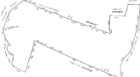
-
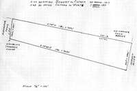
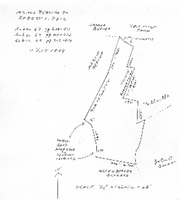
west side -- tract B (employee cottages
THIS INDENTURE, Made the 11th day of September, Nineteen Hundred and Sixty-eight, between WALRUS, INC., a New York Corporation organized under the laws of New York, with its principal place of business at 254 Fair Street, Kingston, Ulster County, New York, party of the first part, and LEWIS F. MC LAREN, residing at Town of Esopus, Ulster County, New York, P. O. Box 218, party of the second part, WITNESSETH that the party of the first part, in consideration of TEN Dollars ($10.00) lawful money of the United States, and other good and valuable consideration paid by the party of the second part, does hereby grant and release unto the party of the second part and assigns forever, ALL THAT PLOT OF LAND with the building thereon situate in the Town of Esopus, County of Ulster and State of New York, bounded and described as follows: BEGINNING at a point, said point being where the center line of Old Post Road intersects the right of way line of Route 9-W leading from Highland to Kingston, and running thence through the center line of said Old Post Road the following courses and distances: north thirty-two degrees nine minutes no seconds west two hundred thirty-four and fifty-seven one hundredths feet; thence north twenty-eight degrees twenty-five minutes no seconds west three hundred thirty-five and no one-hundredths feet; thence north twenty-five degrees thirty-four minutes thirty seconds west fifty and three one-hundredths feet; thence north nineteen degrees eleven minutes twenty seconds west fifty one and seventy-two one hundredths feet; thence north fourteen degrees fifty-eight minutes ten seconds west fifty-four and eighty-nine one hundredths feet; thence continuing along the center line of said Old Post Road north thirteen degrees twenty-four minutes thirty seconds west two hundred and forty and ninety-eight one-hundredths feet; north one degree sixteen minutes forty seconds east one hundred and eleven and forty-seven one-hundredths feet and north twenty-one degrees forty four minutes twenty seconds east seventy-three and twenty-five one hundredths feet to a stone wall and the southwest corner of a cemetery thence running along the southerly line of said cemetery and the center line of said stone wall, south eighty-two degrees fifty-six minutes fifty seconds east ninety feet to the southeast corner of said cemetery and another stone wall, and thence running along the easterly line of said cemetery and the center line of said stone wall north nine degree eleven minutes thirty seconds east one hundred and eighteen and thirty-eight one-hundredths feet to the southerly line of the land now or formerly of James and a stone wall; thence running along the southerly line of said last mentioned land and part of the way along the center line of said stone wall, south seventy-three degrees twenty-seven minutes twenty seconds east eighty-one and seventy-two one-hundredths feet and south seventy-seven degrees twenty-seven minutes ten seconds east four hundred and seven and seventy-three one-hundredths feet to the westerly side of said highway leading from Highland to Kingston, known as Route 9-W; thence running along the westerly side of said State Highway leading from Highland to Kingston known as Route 9-W, south six degrees thirty-one minutes ten seconds west one hundred and seventy-two feet and south fifteen degrees fifty-seven minutes thirty seconds west two hundred and eighteen and sever one-hundredths feet. to a corner of land formerly of Pell, now or formerly of Beatty and occupied by Barringer Service Station, at a stone wall; thence running along the westerly line of said last mentioned land and along the center line of said stone wall, south thirty-five degrees forty-four minutes thirty second west one hundred-and one and thirty-five one-hundredths feet and south thirty-three degrees thirty-two minutes twenty seconds west two hundred and fifty-three and seventy-nine one-hundredths feet to the center line of the former road connecting Route 9-W with the Old Post Road, and now said to be abandoned; thence running along the center line of said road now said to be abandoned and still along said land formerly of Pell, now or formerly of Beatty south forty-eight degrees seventeen minutes forty seconds east one hundred feet and south ten degrees thirty-one minutes twenty seconds east one hundred and five and fifty-seven one-hundredths feet to the westerly side of said State Highway leading from Highland to Kingston, known as Route 9-W; thence running along the westerly side of said State Highway, known as Route 9-W, the following courses and distances: south ten degrees seven minutes thirty seconds west two hundred and six and sixty-six one-hundredths feet to the center line of the Old Post Road, the point or place of beginning. TOGETHER with a reservoir or pump house located on other lands of the parties of the first part on the westerly side of Old Route 9-W, and a strip of land fifty (50) feet wide extending twenty five (25) feet o9n each side of the pipe leading from said pump house to Old Route 9-W and including the lands around said pump house within a distance of ten (10) feet from the outside walls of the pump house, and the right to use such water as may be necessary for school purposes from the stream supplying said pump house. BEING the same premises conveyed to Walrus, Inc., by Wiltwyck School for Boys, Inc. by deed dated May 2, 19676 and recorded in the Ulster County Clerk's Office in Liber 1196 of Deeds at page 983. COVENANTED by the Grantor that road adjoining the above described premises on the south, known as Black Creek road, is a public highway. TOGETHER with the appurtenances and all the estate and rights of the party of the first part in and to said premises. TO HAVE AND TO HOLD the premises herein granted unto the party of the second part, and assigns forever. IN WITNESS WHEREOF, the party of the first part has caused its corporate seal to be hereunto affixed, and these presents to be signed by its duly authorized officer this 11th day of September, Nineteen Hundred and Sixty-eight, Walrus, Inc. By Walter R. Seaman STATE OF NEW YORK } COUNTY OF ULSTER } SS. On this 11th day of September, Nineteen Hundred and Sixty-eight before me personally came Walter R. Seaman to me personally known, who, being by me duly sworn, did depose and say that he resides in Town of Lloyd that he is the President of Walrus, Inc., the corporation described in, and which executed, the within instrument; that he knows the seal of said corporation; that the seal affixed to said instrument is such corporate seal; that it was so affixed by order of the Board of Directors of said corporation; and that he signed his name thereto by like order George Rusk, Jr. Notary Public, State of New York Appointed in Ulster County Commission Expires March 30, 1970 Filed 1:05 PM, Sep 25, 1968 Albert Spada, Ulster County Clerk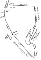
-
west side -- tract A (barn buildings
THIS INDENTURE, made the 2nd day of May, nineteen hundred and sixty-seven, between WILTWICK SCHOOL FOR BOYS, INC., a New York membership corporation having its principal office at 260 Park Avenue South, New York, N.Y., party of the first part, and WALRUS, INC., a New York corporation having its principal place of business at 254 Fair Street, Kingston, New York, party of the second part, WITNESSETH, that the party of the first part, in consideration of Ten ($10.00) dollars, lawful money of the United States, paid by the party of the second part, does hereby grant and release unto the party of the second part, the heirs, or successors and assigns of the party of the second part forever, ALL that certain plot, piece or parcel of land, with the buildings and improvements thereon erected, situate, lying and being in the Town of Esopus, County of Ulster and State of New York, more particularly described on Schedule A annexed hereto and hereby made a part hereof. TOGETHER with the right of the Grantor, if any, to cross the right-of-way of the New York Central Railroad Company adjacent to a portion of the premises. TOGETHER with all right, title and interest, if any, of the party of the first part in and to any streets and roads abutting the above described premises to the center lines thereof, TOGETHER with the appurtenances and all the estate and rights of the party of the first part in and to said premises, TO HAVE AND TO HOLD the premises herein granted unto the party of the second part, the heirs or successors and assigns of the party of the second part forever. AND the party of the first part, in compliance with section 13 of the Lien Law, covenants that the party of the first part will receive the consideration for this conveyance and will hold the right to receive such consideration as a trust fund to be applied first for the purpose of paying the cost of the improvement and will apply the same first to the payment of the cost of the improvement before using any part of the total of the same for any other purpose. The word "party" shall be construed as if it read "parties" whenever the sense of this indenture so requires. IN WITNESS WHEREOF, the party of the first part has duly executed this deed the day and year first above written. WILTWYCK SCHOOL FOR BOYS, INC. By Carl M. Spero, Treasurer STATE OF NEW YORK, COUNTY OF NEW YORK On the 2nd day of May, 1967, before me personally came Carl M. Spero to me known, who, being by me duly sworn, did depose and say that he resides at No. 139 East 94th Street, New York, N.Y., that he is the Treasurer of Wiltwyck School for Boys, Inc., the corporation described in and which executed the foregoing instrument; that he knows the seal of said corporation; that the seal affixed to said instrument is such corporate seal; that it was so affixed by order of the board of directors of said corporation, and that he signed his name thereto by like order. Joseph E. Browdy Notary Public, State of New York Qualified in New York County Commission Expires March 30, 1968 Filed 2:06 PM, May 17, 1967 Albert Spada, Ulster County Clerk Schedule A Annexed to and Forming Part of Deed dated May 1, 1967 from Wiltwyck School for Boys, Inc. to Walrus, Inc. All that plot of land with the building thereon in the Town of Esopus, County of Ulster and State of New York, bounded and described as follows: -- BEGINNING at a point on the westerly side of the State Highway leading from Highland to Kingston known as Route 9-W adjoining the northeast corner of land now or formerly belonging to Dr. Gordon and a stone wall; thence running along the northerly line of said land now or formerly of Dr. Gordon the following courses and distances: north sixty-five degrees fifty-two minutes forty seconds west one hundred and twelve and seventy-five one-hundredths feet; north sixty-seven degrees twenty-one minutes thirty seconds west three hundred and seventy-six and ninety-nine one-hundredths feet; north sixty-six degrees forty-five minutes twenty seconds west seven hundred and forty and thirty one-hundredths feet; north sixty-six degrees fifty-five minutes fifth seconds west two hundred and thirty-seven and twenty-nine one-hundredths feet to the easterly line of land of the New York Central Railroad Company, formerly West Shore Railroad, thence running the following courses and distances for the easterly line of said Railroad land north nine degrees seventeen minutes no seconds west four hundred and fifty-seven and 6 one-hundredths feet; northwesterly on a curve to the right having a radius of one thousand three hundred and eighty-two and seven tenths feet a distance of six hundred and sixty-three and sixty-five one-hundredths feet north eighteen degrees thirteen minutes no seconds east eight hundred and eighty-three feet, northerly on a curve to the left having a radius of two thousand nine hundred and fourteen and nine tenths feet a distance of five hundred and forty-three and thirty-four one-hundredths feet and north seven degrees thirty-two minutes no seconds east four hundred and five and sixty eight one-hundredths feet to the southerly line of land now or formerly of Henken; thence south eighty-eight degrees twelve minutes forth seconds east part of the way along the center line of a stone wall one hundred and ninety-five and thirty-five one-hundredths feet to another corner of said land now or formerly of Henken; thence running still along said last mentioned land north three degrees forty-two minutes no seconds east forty-one and eighty-five one-hundredths feet; north thirteen degrees four minutes ten seconds west sixty-four and seventy-four one-hundredths feet; north eight degrees fifty-seven minutes ten seconds west sixteen and twenty-six one-hundredths feet; north thirty-one degrees twenty-eight minutes fifty seconds east nineteen and seventy-eight one-hundredths feet and north sixty-eight degrees fifty-two minutes ten seconds east two hundred and two and sixty-two one-hundredths feet to the center line of the old Post Road; thence through the center line of the old Post Road the following courses and distances: south fourteen degrees fifty-eight minutes ten seconds east fifty-four and eighty-nine one-hundredths feet; thence south nineteen degrees eleven minutes twenty seconds east fifty-one and seventy-two one-hundredths feet; thence south twenty-five degrees thirty-four minutes thirty seconds east fifty and three one-hundredths feet; thence south twenty-eight degrees twenty-five minutes no seconds east three hundred thirty-five and no one-hundredths feet; then south thirty-two degrees nine minutes no seconds east two hundred thirty-four and fifty-seven one-hundredths feet; thence south one degree twenty-one minutes thirty seconds west one hundred and thirty-four and nineteen one-hundredths feet; and south five degrees nine minutes no seconds west eight hundred and seven and twenty one-hundredths feet; to the northeast corner of land conveyed by New York Protestant Episcopal City Mission Society to Church of the Ascension for a cemetery; thence running along the northerly line of said last mentioned land north eighty-one degrees thirty-seven minutes no seconds west two hundred feet to the northwest corner of said cemetery plot; thence running along the westerly line of said land so conveyed to the Church of the Ascension south three degrees thirty-five minutes seventeen seconds west one hundred and ten feet to the northerly line of another cemetery parcel belonging to the Church of the Ascension at a stone wall; thence running along the center lineof said stone wall north eighty-one degrees thirty-seven minutes no seconds west one hundred and forty-seven and nineteen one-hundredths feet to a stone wall; thence running along the westerly line of said cemetery parcel belonging to the Church of the Ascension and along the easterly line of a small part of said cemetery parcel conveyed by the Church of the Ascension to New York Protestant Episcopal City mission Society south three degrees forty-one minutes five seconds west two hundred and eleven and forty-seven one-hundredths feet; to the southerly line of said cemetery parcel of the Church of the Ascension at a stone wall; thence running along the southerly line of said last mentioned land and along the center line of said stone wall south eighty-one degrees fifty-seven minutes twenty seconds east three hundred and fifty-four and forty-six one-hundredths feet; to the westerly side of the said highway leading from Highland to Kingston, known as Route 9-W and thence along the westerly side of said State Highway, known as Route 9-W the following courses and distances: south one degree thirty-nine minutes no seconds west two hundred and sixteen and twenty-seven one-hundredths feet; south four degrees two minutes no seconds west five hundred and twenty one-hundredths feet; south six degrees thirty-nine minutes no seconds east one hundred and fifty-one and ninety one-hundredths feet; south four degrees twenty eight minutes ten seconds east sixty-one and thirty-four one-hundredths feet; south sixteen degrees fifty-one minutes no seconds east twenty-six and eighty-four one-hundredths feet; and south twenty degrees forty-one minutes no seconds east eight hundred and sixty-two and five one-hundredths feet; to the point of beginning. this is a transcription of a deed located in the Ulster County Clerk's Vault Room, Kingston, New York THIS INDENTURE, Made the 5th day of November, Nineteen Hundred and Sixty-Eight Between Walrus, Inc., a corporation organized under the laws of the State of New York, with its principal place of business located at 254 Fair Street, Kingston, Ulster County, New York, party of the first part, and PHILIP P. HELLRIEGEL AND JAMES R. SHIELDS, both of P. O. Box 92, Esopus, Ulster County, New York, as tenants in common, parties of the second part, WITNESSETH that the party of the first part, in consideration of TEN and 00/100 Dollar ($10.00) lawful money of the United States, and other good and valuable consideration paid by the parties of the second part, does hereby grant and release unto the parties of the second part, their distributees and assigns forever ALL THAT PLOT OF LAND with the buildings thereon in the Town of Esopus County of Ulster and State of New York, bounded and described as follows: BEGINNING at a point on the Westerly side of the State Highway leading from Highland to Kingston, known as Route 9 -W adjoining the Northeast corner of land now or formerly belonging to Dr. Gordon and a stone wall; thence running along the Northerly line of said land now or formerly of Dr. Cordon the following courses and distances: North 65º 52 , 40"West 112 .75 feet; North 67º 21' 30" West 376.99 feet; North 66º 45' 20" West 740.30 feet; North 66º 55' 50" West 237.29 feet to the Easterly line of land of the New York Central Railroad Company, formerly West Shore Railroad, thence running the following courses and distances for the Easterly line of said Railroad land North 9º17' 00" West 457.06 feet; Northwesterly on a curve to the right having a radius of 1382.7 feet a distance of 663.65 feet, North 18° 13' 00" East 883 feet; Northerly on a curve to the left having a radius of 2914.9 feet a distance of 543.34 feet and North 7º 32, 00" East 405.68 feet to the Southerly line of land now or formerly of Henken South 88º 12' 40" East part of the way along the center line of a stone wall 195.35 feet to another corner of said land now or formerly of Henken; thence running still along said last mentioned land North 3º 42' 00" East 41.85 feet; North 13º 4' 10" West 64.74 feet; North 8º 57' 10" West 16.26 feet; North 31º 28' 50" East 19.78 feet and North 68º 52' 10" East 202.62 feet to the center line of the Old Post Road; thence through the center line of the Old Post Road the following courses and distances: South 14º 58' 10" East 54 89 feet, thence South 19º 11' 20" East 51.72 feet; thence South 25º 34' 30" East 50.03 feet; thence South 28º 25' 00" East 335.00 feet; thence south 32º 9' 00" East 234.57 feet; thence South 19º 21' 30" West 134.19 feet and South 5º 9' --" West 807.20 feet to the Northeast corner of land conveyed by New York Protestant Episcopal City Mission Society to Church of the Ascension for a cemetery; thence running along the Northerly line of said last mentioned land North 81º 37' 00" West 200 feet to the Northwest corner of said cemetery plot; thence running along the Westerly line of said land so conveyed to the Church of the Ascension South 3º 35' 17" West 110 feet to the Northerly line of another cemetery parcel belonging to the Church of the Ascension a t a stone wall; thence running along the Northerly line of said cemetery parcel of the Church of the Ascension and along the center line of said stone wall North 81º 37' 00" West 147.19 feet to a stone wall; thence running along the Westerly line of said cemetery parcel belonging to the Church of the Ascension and along the Easterly line of a small part of said cemetery parcel conveyed by the Church of the Ascension to New York Protestant Episcopal City Mission Society South 3º 41' 5" West 211.47 feet to the Southerly line of said Cemetery parcel of the Church of the Ascension at a stone wall; thence running along the Southerly line of said last mentioned land and along the center line of said stone wall South 81º 57" 20" East 354.46 feet to the Westerly side of the said highway leading from-Highland to Kingston, known as Route 9-W and thence along the Westerly side of said State Highway, known as Route 9-W the following courses and distances: South 1º 39' 00" West 16.27 feet; South 4º 2' 00" West 500.20 feet; South 6º 39' 00" East 151.90 feet; South 4º 28' 10" East 61.34 feet; South 16º 51' 00" East 26.84 feet and South 20º 41' 00" East 862.05 feet to the point of beginning. SUBJECT to the rights of the public to any highway adjacent to said premises. SUBJECT to the rights of New York Central and/or West Shore Railroad in the right of way running through said premises. SUBJECT to any state of facts which a survey may show. SUBJECT to any public utilities or other easements under recorded agreements. EXCEPTING from the said premises a reservoir or pump house and a right of way leading therefrom as granted to Lewis F. Mc Laren in a deed from the seller dated September 11th, 1968, and recorded in the Ulster County Clerks Office in Liber 1218 of Deeds at Page 485 on September 25, 1968. TOGETHER with the right of the Grantor if any, to cross the right-of-way of the N. Y. Central Railroad Company adjacent to a portion of the premises. TOGETHER with the appurtenances and all the estate and rights of the party of the first part in and to said premises, TO HAVE AND TO HOLD the premises herein granted unto the parties of the second part, their heirs and assigns forever. AND the party of the first part, in compliance with section 13 of the Lien Law, covenants that the party of the first part will receive the consideration for this conveyance and will hold the right to receive such consideration as a trust fund to be applied first for the purpose of paying the cost of the improvement and will apply the same first to the payment of the cost of the improvement before using any part of the total of the same for any other purpose. IN WITNESS WHEREOF, the party of the first part haws caused its corporate seal to be hereunto affixed, and these presents to be signed by its duly authorized officer this 5th day of November Nineteen Hundred and sixty Eight. WALRUS, INC. By Walter R. Seaman State of New York } County of Ulster } ss. On this fifth day of November, Nineteen Hundred and Sixty-eight before me personally came Walter R. Seaman, to me personally know, who, being by me duly sworn, did depose and say that he resided in the Town of Esopus, Ulster County, New York; that he is the President of WALRUS, INC., the corporation described in, and which executed, the within instrument; that he knows the seal of said corporation; that the seal affixed to said Instrument is such corporate seal; that is was so affixed by order of the Board of Directors of said corporation; and that he signed his name thereto by like order. George Rusk, Jr. Notary Public, State of New York Appointed in Ulster County] Commission Expires March 30, 1969 Filed 9:00 A. M., Nov 8, 1968 Albert Spada, Ulster County Clerk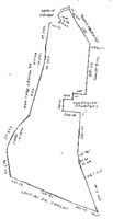
-
Logical View of the Payne Properties
These sections are not geographically correct. They are intended to describe the properties when Fuller purchased them for Oliver Hazard Payne. A: South section between Hudson River and route 9W - sold by Brothers in 1985 B: North section between Hudson River and route 9W - now Marist Brothers C: South section between route 9W and Floyd Ackert Road D: North section Beavers to Pell to Pratt to Payne E: Gravel hill located west of Floyd Ackert Road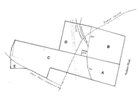
-
patents
no deed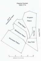
-
southern slice
no deed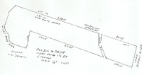
-
northern slice
no deed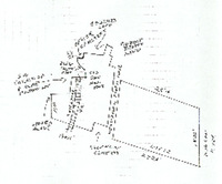
-
Official Payne Survey of 1910
This is the survey of the Payne property completed March 1910 by John Ogden. No owner name is noted on the survey, indicating that there was still secrecy associated with the transactions.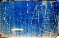
-
Alfred Sands Pell <==> Cameron
no deed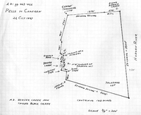
-
Payne Property -- North Section
THIS INDENTURE made the twelfth day of August in the year one thousand nine hundred and nine, BETWEEN ANNA T. PRATT AND ELIZABETH, COMTESSE DE GASQUET JAMES of Dinard, France parties of the first part, and WILLIAMSON W. FULLER of the City, County and State of New York, party of the second part, WITNESSETH; - that the said parties of the first part in consideration of ONE Dollar lawful money of the United States, paid by the party of the second part, do hereby grant and release unto the said party of the second part, his heirs and assigns forever, ALL THAT CERTAIN farm of land situate in the Town of Esopus Ulster County N. Y. adjoining the Hudson River and bounded as follows: -Beginning at the southeast corner of the farm given to John Oliver Beaver under the will of John Beaver, deceased, running thence along the north bounds of the lands formerly of the Widow Wurts now (1859) of John Jacob Actor easterly to the Hudson River at a yellow pine tree cornered and marked, then northerly along said river to the lands of Robert L. Pell, then westerly along the same to the lands formerly in the possession of the heirs of Peter Beaver now (1859) of Robert L. Pall at a cross fence and wall, then southerly along the said fence and wall to the place of beginning. Containing, 65 acres more or less. Also all that certain other parcel of land situate in the Town and County aforesaid adjoining the above named premises and being the parcel given to John Oliver Beaver by the last will and testament of John Beaver, deceased, and bounded as follows, to wit:- On the east by the last named premises cross fence and wall, , south by lands formerly belonging to the Widow Wurts now (1859) to John Jacob Astor on the west by the public highway leading from Rondout to Newburgh and on the north by lands formerly belonging to Myer G Beaver and the farm of Robert L. Pell containing 60 acres be the same more or less. The foregoing two parcels being the same premises conveyed to the late George W. Pratt by Robert L. Pell and wife by deed dated May 24, 1859 and recorded in the Ulster County Clerk's Office July 23, 1859 in Book 108 of Deeds page 566. Also all that certain farm or piece of land situate lying and being in the Town of Esopus, Ulster County N. Y., now (1886) in the occupation of the widow Asael G. Beaver as the homestead farm of John Beaver, deceased, and bounded generally as follows:- On the north by lands formerly belonging to the heirs or Nicholas Murphy deceased, and the factory lot, on the east by lands now or lately of Robert L. Pell, and by the above described premises of the late George W. Pratt, on the south by lands now or late of said George W. Pratt and of Archibald Russell and on the west by said factory lot and lands now or late of Cornelius Relyea, being the same premises conveyed by James Crowthers and wife to Joseph Greaves in year 1858. Excepting and reserving thereout so much of said premises as were heretofore conveyed by Robert L. Pell and wife to the Church of the Ascension for a cemetery. And also excepting and reserving therefrom the premises heretofore conveyed to the New York West Shore and Buffalo Railway Company. Being the same premises conveyed to the said Anna T. Pratt by Sarah Matilda Wygatt and Angeline E. Darling, as surviving executors of and Trustees under the last will and testament of Jacob A. Robertson by deed dated January 15, 1886 and recorded in the Clerk's Office of Ulster County January 24, 1886 in Book 264 of deeds page 433. The grantee herein has caused the premises above described to be surveyed and a map thereof to be made which is to be filed herewith but the covenants and warranty in this deed apply only to the premises as above described, and the grantors herein do not in any manner warrant the accuracy of said survey and map. TOGETHER WITH THE APPURTENANCES and all the estate and rights of the parties of the first part, in and to said premises. TO HAVE AND TO HOLD the above granted premises unto the said party of the second part, his heirs and assigns forever. And the said parties of the first part do covenant With the said party of the second part as follows:- That the party of the second part shall quietly enjoy the said premises That the said parties of the first pert will forever warrant the title to said premises. IN WITNESS WHEREOF the said parties of the first part have hereunto set their hands and seals the day and year first above written. In presence of . Raymond Moulton Anna T. Pratt( L. S.) Elizabeth, Comtesse de Gasquet-James (LS) REPUBLIC OF FRANCE : DEPARTMENT OF ILLE ET VLAINE : SS. CITY OF ST MALO : On this 12th day of August in the year one thousand nine hundred and nine before me, the subscriber, a Consular Agent, of the United States of America in and for said Town of St. Malo, Republic of France residing within said City of Malo personally appeared Anna. T. Pratt and Elizabeth, Comtesse de Gasquet-James, to me known and known to me to be the individuals described in and who executed the foregoing instrument, and they thereupon severally acknowledged to me that they executed the same. Seal RaymonD Moulton, Consular Agent of the United $2 Fee Stamp States of America. A true record entered Sept. 18, 1909 at 8:27 A. M. handwritten signature Clerk THIS INDENTURE, made the 28th day of October, in the year nineteen hundred and nine. BETWEEN WILLIAMSON W. FULLER and ANNIE M. FULLER, his wife, of the City, County and State of New York, parties of the first part, and OLIVER H. PAYNE, of the City. County and State of New York, party of the second part. WITNESSETH. That the said parties of the first part, in consideration of one dollar and other valuable consideration, lawful money of the United States, paid by the party of the second part, do hereby remise, release and forever quit-claim and convey unto the party of the second part, his heirs and assigns forever, ALL THAT CERTAIN tract or parcel of land, situate in the town of Esopus, Ulster County, N. Y. beginning at a point on the westerly side of the Hudson River, at the northeasterly corner of land now owned by 0. H. Payne (by deed of W. W. Fuller dated January 5. 1909) and running from thence by survey of May, 1909. north 70 degrees 37 minutes west 2823 5/10 feet to a point in the center of the highway leading from West Park to Esopus, thence north 50 minutes west along the center of said highway, 282 feet to a point, thence north 83 degrees 10 minutes west passing along the northerly side of a cemetery, 381 feet to the northwesterly corner of said cemetery, thence south 23 degrees 40 minutes west 104 feet, thence south 17 degrees 50 minutes west 68 feet, thence south 1 degree 35 minutes west 24 feet to a point in the westerly line of said cemetery, thence north 71 degrees west crossing Black Creek. and the N. Y. S. & B. Railway; and continuing along the northerly line of said Payne's (formerly Fuller's) land 1307 feet to a stone heap by a wall, thence north 2 degrees 20 minutes east along the edge of the timber, 750 feet to an old stone heap; thence south 83 degrees 57 minutes east along a row of marked trees 617 feet to an old stone, monument, thence north 13 degrees 25 minutes east along a row of marked trees, 484 feet. to a stake and stones at the southwesterly corner of what is termed the eight acre factory lot; thence south 89 degrees 45 minutes east crossing the above mentioned railway 375 5/10 feet to a point; thence north 5 degrees west along what was originally the Saw Mill pond 81 5/10 feet to a point, thence north 24 degrees 10 minutes east 52 2/10 feet to a point, thence north 47 degrees 15 minutes east 39 5/10 feet to a point, thence north 72 degrees 15 minutes east continuing along the outline of the old saw mill pond and crossing the creek, 149 feet to a point in the center of the above mentioned highway, thence north 17 degrees 15 minutes west 241 5/10 feet to a point; thence north 2. degrees west 100 feet to a point in the center of the highway; thence north 11 degrees east 100 feet, to a point in the center of tie highway. thence south 84 degrees 55 minutes east leaving the highway and passing along the southerly side of another cemetery 90 feet to the southeasterly corner thereof, thence north 8 degrees 10 minutes east along the easterly side of the last mentioned cemetery, 117 feet to a point in the easterly line thereof; thence south 76 degrees 10 minutes east along the southerly line of lands formerly of A. D. James, 85 feet to a point; thence south 80 degrees 10 minutes east 187 feet to a point, thence south 78 degrees 40 minutes east 229 feet to a point, thence south 74 degrees 50 minutes east 89 feet to a point, the southeasterly corner of said James' lands; thence along the east line of said James land north 20 degrees 35 minutes east 319 feet, to the south line of lands of Robert Beatty, thence along the lands of said Beatty the following courses and distances south 42 degrees 15 minutes east 66 feet, south 82 degrees,15 minutes east 89 foot to a corner, south 23 degrees 45 minutes west 254 feet to a corner, south 76 degrees 15 minutes east crossing a creek, 112 feet to a corner, south 26 degrees 45 minutes west on the east side of said creek. 284 feet to a corner south 73 degrees 15 minutes east 197 feet to a corner, south 7 degrees 45 minutes west 283 feet to a corner. south 70 degrees east 2514 foot to the Hudson River, thence southerly along the west side of said river 1822 feet to the place of beginning. Excepting and reserving from the above described premises the right of way, tract or parcel of land heretofore conveyed to or acquired by the New York, West Shore and Buffalo Railway Company. Containing exclusive of said Railway Company's land, 179 635/1000 acres of land, and being the same premises conveyed by Anna T. Pratt and Elizabeth Comtesse de Gasquet James to Williamson W. Fuller, by deed dated August 12, 1909, and recorded in the Ulster County Clerk's office, September 18. 1909. TOGETHER with the appurtenances, and all the estate and rights of the parties of the first part in and to said premises. T0 HAVE AND TO HOLD the above mentioned and described premises unto the party of the second part, his heirs and assigns forever. IN WITNESS whereof, the said parties of the first part have hereunto set their hands and seals the day and year first above written. In presence of, R. J. Boylan Williamson W. Fuller, (seal) Annie M. Fuller. (seal) STATE OF NEW YORK COUNTY OF NEW YORK: SS.: 0n this 28th day of October, 1909, before me, the undersigned, personally came and appeared WILLIAMSON W. FULLER and ANNIE M. FULLER, his wife to me known and known to me to be the individuals described in and who executed the foregoing instrument, and severally acknowledged to me that they executed the same R. J. Boylan Notary Public No. 286, Kings County N. Y Register's certificate no. 2025 Certificate filed in New York County, N.Y., No. 1251 My Commission expires March 30, 1911 STATE OF NEW YORK COUNTY OF NEW YORK: ss.: I, PETER J. DOOLING, Clerk of the County of New York, and also Clerk of the Supreme Courty for the said County, the same being a court of Record, Do hereby Certify that R. J. BOYLAN has filed in the Clerk's office of the County of New York, a certified copy of his appointment and qualification as Notary Public, for the County of Kings, with his autograph signature, and was at the time of taking the proof or acknowledgment, of the annexed instrument, duly authorized to take the same. And further that I am well acquainted with the the handwriting of such Notary, and believe the signature to the said certificate of proof or acknowledgment to be genuine. IN TESTIMONY WHEREOF, I have hereunto set my hand and affixed the seal of the said Court and County, the 28 day of Oct., 1909. Peter J. Dooling, Clerk A true record entered Nov. 1, 1909, at 9:25 A. M.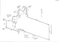
-

-
-
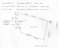
-
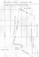
-
Payne Estate - Southern Slice
THIS INDENTURE Made this fifth day of January in the year nineteen hundred and nine, BETWEEN WILLIAMSON W. FULLER and ANNIE M. FULLER his wife, of the City County and State of New York, parties of the first part, and OLIVER H. PAYNE of the City County and State of New York party, of the second part, WITNESSETH: That the said parties of the first part for and in consideration of One Dollar ($1.00) and other valuable consideration lawful money of the United States, paid by the said party of the second part do hereby remise, release and forever quit-claim unto the said party of the second part, his heirs and assigns forever, ALL THAT CERTAIN tract of land with the buildings thereon erected situate lying and being at Esopus, Ulster County in the Stale of New York, being a portion of lot number eleven (11) of the three mile or river lots in the north division of the Patent of New Paltz lying and situate in the Township of Esopus, County of Ulster and State of New York, which said tract of land is bounded and contains as follows; Beginning on the Hudson River at a pitch pine tree on the division line between lots numbers eleven and twelve (12) in said patent, thence running along said division line north seventy four (74) degrees west forty two (42) chains sixty eight (68) link to the center of the public highway leading from Newburgh to Kingston, thence (2) along said highway south four (4) degrees east thirteen (13) chains more or less to the entrance gate thence (3) still along said highway south twenty seven (27) degrees east thirteen (13) chains and fifty five (55) links more or less to the south line of the said tract, thence (4) along said line as the fence now stands south seventy two (72) degrees east thirty one (31) chains and thirty (30) links to the Hudson River thence (5) along said river in a northerly direction about twenty four (24) chains to the place of beginning., Containing as surveyed by Mark W. Powell in December 1851 eighty (80) acres and sixtenths (6/10) of an acre be the said several dimensions or contents more or less. Being the same premises conveyed to said Adam Neidlinger by Alexander Holland end wife by deed dated the 20th day of May 1884, and recorded in the Clerk's Office of the County of Ulster on the 22nd day of May 1884, in Book 251 of Deeds page 359. And also all the right title interest, estate and advantages which the said Alexander Holland and wife have acquired and now have or might hereafter have by virtue of a certain Act of the legislature of the State of New York entitled "An act to Authorize Archibald Russell to erect a dock or wharf in the Hudson River in the Town of Esopus adjoining his lands passed May 14, 1845, and all other riparian rights of said parties hereto of the first part And also all that certain tract, piece or parcel of land situate lying and being in the town of Esopus, County of Ulster and State of New York bounded and described as follows:- Beginning at a point in the highway leading from Newburgh to Kingston where the division line between lot eleven (11) and lot twelve (12) of the three mile or river lots in the north division of the New Paltz crosses said highway at or near the southerly boundary of a cemetery running thence along said line north 71 30' west six thousand five hundred and, eighty nine (6589) feet more or less thence south 45 west six hundred and sixty four (654) feet more or less thence south 17' 15' west seven hundred and fifty two (752) feet to the highway known as the West Park Road thence in a south easterly direction along said highway as it winds and turns to a stake and stones, being the corner of land now or late of M. W. Powell, thence north 13 3/4' east four hundred (400) feet, thence north 12' east four hundred (440) feet, thence north 5 1/2' seat two hundred (200) feet thence north 14 30' east two hundred and thirty (230) feet, thence south 69' 30' east nineteen hundred and fifteen (1915) feet to the end of stone wall thence south 70 10' east three thousand seven hundred and twenty (3720) feet to said highway leading from Newburgh to Kingston and thence northerly along said highway as it winds and turns,, seventeen hundred and fifty three (1753) feet, to the point or piece of beginning. Excepting therefrom the land conveyed by Helen R. Russell to the New York West Shore and Buffalo Railway Company by deed dated November 16th, 1881, and recorded in the office of the Clerk of Ulster County in Book of Deeds Number 232, at page 160, etc. Containing after deducting the lands of said Railway Company two hundred and sixteen 19/100 acres be the same more or less. Being the tract or parcel of land thirdly described in and conveyed by a certain dead bearing date the seventh day of December in the year 1885, made and executed by Helen R. Russell to Cynthia Helen Durkee the wife of Eugene R. Durkee and recorded in the office of, the Clerk of the County of Ulster on the eighth day of December in the year 1885 in Book 260 of Deeds at page 612, and a part of the real estate ff which the said Cynthia Helen Durkee died seized and which by her last will and testament bearing date May 22, 1874, and duly proved and admitted to probate in and by the Surrogate's Court of the County of Ulster on the l0th day of June in the year 1890 was by her devised to her husband, the said Eugene R. Durkee. It being understood that the courses given in the foregoing description are taken from surveys made by A. Grant Childs, November 1885. And all right title and interest of the parties hereto of the first part to one half in width of the roads or highways lying opposite and adjacent to said premises. Being the same premises conveyed to said Adam Neidlinger by Eugene R. Durkee by deed dated August 13th, 1890, and recorded in the Clerk's Office of Ulster County on the 18th day of August, 1890 in Book 293 of Deeds page 629. And also all that certain point of a gravel hill lying in said Town of Esopus on the southwest side of the Hyde Park and Dashville Road, being bounded as follows:- Beginning at a stone set in the ground on the top of said hill and running south six degrees west one chain and seventy five links to the west side of said road. Thence along the west and south sides of said road about three chains and fifty links to the end of a stone wall, thence south ten degrees east one chain and fifty seven links to the place of beginning. Containing one tenth of an acre, subject to the condition that gravel shall not be removed from so close to the line as not to leave as much gravel for the use of the road as the present survey of the road now covers and yet not undermine a fence or wall set upon said line across the gravel hill, and also subject to the reservations of the privilege of drawing a few loads reserved to Elias Terpening if he should want to use it about his house or otherwise. Being the same premises conveyed to said Adam Neidlinger by Eugene R. Durkee by deed dated the 13th day of August 1890 and recorded in Ulster County Clerk's Office on the 18th day or August, l890 in Liber 293 of Deeds gage 628. The property herein conveyed being the same property granted to said Williamson W. Fuller by Louise Neidlinger, George F. Neidlinger and Rudolf G. Neidlinger as Executrix and Executors of and Trustees under the last will and testament or Adam Neidlinger, late of West Park, Ulster County New York deceased, by deed dated the 29th day of December, in the year one thousand nine hundred and eight, and by Louise Neidlinger, widow of Adam Neidlinger, deceased, and Elizabeth Weber, George P. Neidlinger, unmarried, Emma Louise Von Bernuth, Henry T. Neidlinger, and Emily Neidlinger, his wife, and Rudolf G. Neidlinger unmarried, Children and heirs at law of said Adam Neidlinger, deceased by deed dated the 28th. day of December, in the year nineteen hundred and eight, . TOGETHER WITH THE APPURTENANCES all the estate and rights of the parties of the first part in and to said premises. TO HAVE AND TO HOLD The above mentioned and described premises unto the said party of the second part, his heirs and assigns forever. IN WITNESS WHEREOF The said parties of the first part have hereunto set their hands and seals the day and year first above written. In presence of. R. J. Boylan Williamson W. Fuller Seal Annie M. Fuller Seal STATE OF NEW YORK COUNTY OF NEW YORK : SS. On this 7th day of January in the year one thousand nine hundred and nine, before me, the undersigned, personally came and appeared WILLIAMSON W. FULLER AND ANNIE M. FULLER his wife, to me known and known to me to be the same persons described in and who executed the foregoing Instrument, and severally acknowledged to me the: they executed the same for the uses and purposes therein mentioned. Seal R. J. Boylan, . Notary Public, No. 302, Kings County, N. Y. Registers Certificate No. 2025, Certificate filed in New York County N. Y. My commission expires March 20, 1909. STATE OF NEW YORK : COUNTY OF NEW YORK: SS. I, PETER J. DOOLING, Clerk of the County of New York, and also Clerk of the Supreme Court for the said County, the same being a Court of Record, Do Hereby Certify that R. J. BOYLAN whose name is subscribed to the Certificate of the proof or acknowledgment of the annexed instrument, arid thereon written, was at the time of taking such proof or acknowledgment, a Notary Public in and for the County of New York, dwelling in the said County, commissioned and sworn, and duly authorized to take the name. And further that I am well acquainted with the handwriting of such Notary, and verily believe that the signature to the said certificate of proof or acknowledgment Is genuine. IN TESTIMONY WHEREOF, I have hereunto set my hand and affixed the seal of the said Court and County . Peter J Dooling, Seal. Clerk THIS INDENTURE, Made the twenty ninth day of December, in the year Nineteen hundred and eight. BETWEEN LOUISE NEIDLINGER, GEORGE P. NEIDLINGER and RUDOLF G. NEIDLINGER Executrix and Executors of and Trustees under the last will end testament of Adam Neidlinger, late of West Park, Ulster County, New York, deceased, of the first part, and WILLIAMSON W. FULLER, of the City of New York, party of the second part. . WITNESSETH, That the said parties of the first part, by virtue of the power and authority to them given in and by the said last will and testament, and in consideration of One Hundred ( $100) Dollars, and other valuable considerations lawful money of the United States, paid by the party of the second part, do hereby grant and release unto the said party of the second part, his heirs and assigns forever, ALL THAT CERTAIN TRACT OF LAND, with the buildings thereon erected, situate, lying and being at Esopus, Ulster County, in the Stale of New York, being a portion of Lot number eleven (11) of the three mile or River Lots in the North Division of the Patent of New Paltz, lying and situate in the Township of Esopus, County of Ulster, State of New York, which said tract of land is bounded and contains as follows: Beginning on the Hudson River at a pitch pine tree in the division line between Lots numbers eleven and twelve (11 and 12) in said Patent; thence running along said division line North seventy four (74j degrees west forty two (42j chains sixty eight ( 68 ) links to the centre of the public highway leading from Newburgh to Kingston; thence (2) along said highway south four ( 4 ) degrees east thirteen (13 ) chains more or less to the entrance gate; thence (3) still along said highway south twenty seven (27) degrees east thirteen (13) chains and fifty five ( 55 ) links more or less to the south line of the said tract ; thence (4) along said line as the fence now stands south seventy two (72) degrees east thirty one (31) chains and thirty (30) links to the Hudson River; thence (5) along said River in a Northerly direction about twenty four (24) chains to the place of beginning. Containing as surveyed by Mark R. Powell in December, 1851, eighty (80) acres and six tenths (6/10ths) of an acre be the said several dimensions or contents more or less. Being the same premises conveyed to said Adam Neidlinger by Alexander Holland and wife, by deed dated the 20th day of May, 1884, and recorded in the Clerk's office of the County of Ulster, on the 22nd day of May, 1884, in book 251 of Deeds, page 359. AND ALSO all the right, title, interest, estate and advantages which the said Alexander Holland and wife have acquired and now have or might hereafter have by virtue of a certain act of the Legislature of the State of New York entitled "An act to authorize Archibald Russell to erect a dock or wharf in the Hudson River in the Town of Esopus, adjoining his land" passed May 14, 1845, and all other riparian rights of said parties hereto of the first part. And also all that certain tract, piece or parcel of land, situate, lying and being in the Town of Esopus, County of Ulster and State of New York, bounded and described as follows: Beginning at a point in the highway leading from Newburgh to Kingston where the division line between Lot Eleven (11) and Lot twelve (12) of the three mile or River Lots in the North Division of New Paltz crosses said highway at or near the southerly boundary of a cemetery, running thence along said line North 71' 30' west six thousand five hundred and eighty nine (6589) feet more or less; thence south 40 west six hundred and sixty four (664.) feet more or less; thence south 17' 15' west seven hundred and fifty two (752) feet to the highway known as the West Park Road; thence in a southeasterly direction along said Highway as it winds and turns to a stake and stones, being the corner of the land now or late of M. W. Powell; thence North 13 3/4' East four hundred (400) feet; thence north 12' east four hundred (400) feet, thence North 5 1/2' east two hundred (200) feat; thence North 14' 30' east two hundred and thirty (230) lest; thence south69' 30' east nineteen hundred and fifteen (1915) feet to the end of a stone wall; thence south 70' 10° East three thousand seven hundred and twenty ( 3720) feet to said highway leading from Newburgh to Kingston and thence Northerly along said highway as It winds and turns, seventeen hundred and fifty three (1753) feet to the point or place of beginning. Excepting therefrom the land conveyed by Helen R. Russell to the New York West Shore and Buffalo Railway Company by deed dated November 16th, 1881, and recorded in the office of the Clerk of Ulster County in Book of Deeds Number 232, at page 160, &c. Containing after deducting the lands of said Railway Company two hundred and sixteen 19/100 acres be the same more or less. Being the tract or parcel of land thirdly described in and conveyed by a certain deed bearing date the seventh day of December, in the year 1885, made and executed by Helen R. Russell to Cynthia Helen Durkee, the wife of Eugene R. Durkee, and recorded in the office of the Clark of the County of Ulster on the eighth day of December, in the year 1885, in Book 260 of Deeds at page 612, and a part of the real estate of which the said Cynthia Helen Durkee died seized and which by her Last Will and testament bearing date May 22, 1874, and duly proved and admitted to probate in and by the Surrogate's Court of the County of Ulster on the tenth day of June, in the year 1890, was by her devised to her husband, the said Eugene R. Durkee. It being understood that the courses given in the foregoing description are taken from surveys made by A. Grant Childs, November 1885. And all right, title and interest of the parties hereto of the first part to one half in width of the Roads or Highways lying opposite and adjacent to said premises. Being the same premises conveyed to said Adam Neidlinger by Eugene R. Durkee by deed dated August 13th, 1890, and recorded in the Clerk's office of Ulster County on the 18th day of August, 1890, in book 293 of Deeds page 629. AND' ALSO ALL that certain point of a gravel hill lying in said town of Esopus, on the southwest side of the Hyde Park and Dashville Road,, being bounded as follows: Beginning at a stone set in the ground on the top of said hill and running south six degrees west one chain and seventy five links to the west side of said road, thence along the west and south sides of said road about three chains and fifty links to the end of a stone wall; thence south ten degrees east one chain and fifty seven links to the place of beginning. Containing one tenth of an acre; subject to the condition that gravel shall not be removed from so close to the line as not to leave as much gravel for the use of the road as the present survey of the road now covers and yet not undermine a fence or wall set upon said line across the gravel hill, and also subject to the reservation of the privilege or drawing a few loads reserved to Elias Terpenning, If he should want to use it about his house or otherwise. Being the same premises conveyed to said Adam Neidlinger by Eugene R. Durkee, by deed dated the 13th day of August, 1890, and recorded in Ulster County Clerk's office on the 18th day of August, 1890, in Liber 293 of Deeds page 628. TOGETHER with the appurtenances and also all the estate which the said testator had at the time of his decease in said premises and also the estate therein which the said parties of the first part have or have power to dispose of, whether individually or by virtue of said will or otherwise. TO HAVE AND TO HOLD the above granted premises into the said party of the second part, his heirs and assigns forever. , And the said parties of the firm part covenant with the said party of the second part, that the parties of the first part have not done or suffered anything where by the said premises have been incumbered in anyway whatever. IN WITNESS WHEREOF, the said parties of the first part have hereunto set their hands and seals the day and year first above written. In presence of, Jas. Mc. Smith. Louise Neidlinger, Seal as executrix of and trustee under will of Adam Naidlinger, dec'd. George F. Neidlinger, Seal. as executor of and trustee under will of Adam Neidlinger, dec'd. Rudolf G. Neidiinger, Seal. as executor of and trustee under will of Adam Neidlinger, decd. STATE OF NEW YORK : COUNTY OP NEW YORK:SS,: On this twenty ninth day of December, in the year of our Lord one thousand nine hundred and eight, before me, the undersigned personally came and appeared LOUISE NEIDLINGER, GEORGE F, NEIDLINGER arid RUDOLF G. NEIDLINGER, to me known and known to me to be the individuals described in end who executed the foregoing instrument, and severally acknowledged to me that they executed the same, as Executrix and Executors of and Trustees under the will of Adam Neidlinger, deceased, for the uses add purposes therein mentioned Florence A. O'Brien, Notary Public #1541, . N. Y. Co. STATE OF NEW YORK COUNTY 0F NEW YORK: SS: I , PETER J. DOOLING Clerk of the County of New York, and also Clerk of the Supreme Court for the said County, the same being a Court of Record DO hereby Certify that FLORENCE A. 0' BRIEN, whose name is subscribed to the Certificate of the proof or acknowledgment of the annexed instrument, arid thereon written, was at the time of taking such proof or acknowledgment, a Notary Public in and for the County of New York, dwelling in the said County, commissioned and sworn, and duly authorized to take the name. And further that I am well acquainted with the handwriting of such Notary, and verily believe that the signature to the said certificate of proof or acknowledgment Is genuine. IN TESTIMONY WHEREOF, I have hereunto set my hand and affixed the seal of the said Court and County, the 30 day of Dec., 1908. Peter J Dooling, Seal. Clerk. A true record entered Jan. 11, 1909 at 9:10 A.M. ?? signature Clerk THIS INDENTURE, made the twenty eighth day of December, in the year nineteen hundred and eight. BETWEEN LOUISE NEIDLINGER, widow of Adam Neidlinger, deceased, and ELISABETH WEBER, GEORGE P. NEIDLINGER, unmarried, EMMA LOUISE von BERNUTH, HENRY T. NEIDLINGER and EMILY NEIDLINGER, his wife, andi RUDOLF G. NEIDLINGER, unmarried, children and heirs at law of said ADAM NEIDLINGER, deceased, parties of the first part, and WILLIAMSON W. FULLER, party of the second part. WITNESSETH, That the said parties of the first part, for and in consideration of one ($1) dollar and other valuable considerations, lawful money of the United States, paid by the party of the second part, do hereby remise, release and forever quit-claim unto the said party of the second part, his heirs and assigns forever, ALL OF THE LAND AND PREMISES known as "Waldorf" in the town or Esopus, Ulster County and State of New York, containing about eighty acres more or less, which were conveyed to said Adam Neidlinger by Alexander Holland and wife by deed dated May 20th, 1884, and recorded in the office of the Clerk of the County of Ulster, May 22nd, 1884, in Book 251 of Deeds page 359, together with all the riparian rights owned by the parties of the first part. AND ALSO the farm of land adjoining said premises and separated therefrom by the highway and containing about two hundred and sixteen acres be the same more or less, which were conveyed to said Adrm Neidlinger by Eugene R. Durkee, by deed dated August 13th, 1890, and recorded in the office of the Clerk of Ulster County August 18th, 1890, in Book 293 of Deeds page 629. AND ALSO the gravel pit containing one tenth of an acre; more or less, conveyed to said Adam Neidlinger by Eugene R. Durkee, by deed dated August 13th, 1890, and recorded in the office of the Clerk of the County of Ulster August 18th, 1890, in Liber 293 of Deeds page 628, subject to the conditions, exceptions and restrictions contained in said deed. ALL said three parcels and premises being the same premises conveyed to the party of the second part by the executors of and trustees under the will of Adam Neidlinger, deceased, by a dead intended to be delivered with these presents, which are executed in confirmation thereof. TOGETHER with the appurtenances, and all the estate and rights of the parties of the first part in and to said premises. TO HAVE AND TO HOLD the above mentioned and described premises unto the said party of the second part, his heirs and assigns forever. IN WITNESS WHEREOF, the said parties of the first part have hereunto set their hands end seals the day and year first above written. In presence of, Jas. McG. Smith. Louise Neidlinger, Seal. Elisabeth Weber, Seal. George P. Neidlinger, Seal. Emma L. van Bernuth, Seal. Henry T. Neidlinger, seal. Emily Neidlinger, Seal. Rudolf G. Neidlinger, Seal. STATE OF NEW YORK : COUNTY OF OSWEGO : SS.: On this twenty eighth day of December, in the year of our Lord one thousand nine hundred and eight, before me, the undersigned personally came and appeared HENRY T. NEIDLINGER and EMILY NEIDLINGER, his wife, to me known and known to me to be the individuals described in, and who executed the foregoing instrument, and severally acknowledged to me that they executed the same. Geo. Noyes Burt, Seal. Notary Public, Oswego Co., N. Y. STATE OF NEW YORK : ' OSWEGO COUNTY CLERKS OFFICE : SS.: A, B. SIMPSON, Clerk of said County and of the Supreme and County Courts therein, which are Courts of Record, do hereby certify that GEO. NOYES BURT, Esq., whose name Is subscribed to the certificate of the proof or acknowledgment of the annexed instrument, was at the time of taking such proof or acknowledgment, a Notary Public in and for said County, and duly authorized to take the same, and that I am well acquainted with his handwriting, and I verily believe that the signature to said certificate of proof or acknowledgment is genuine. And I further certify that the said instrument is executed and acknowledged according to the Laws of the State of New York IN TESTIMONY WHEREOF, I have hereunto set my hand and affixed the seal of said County and Courts, at the City of Oswego, this 28 day of Dec., 1908. A. B. Simpson, Seal. Clerk. STATE 0F NEW YORK COUNTY OF NEW YORK: SS.: On this 29th day of December, in the year of our Lord one thousand nine hundred and eight before me, the undersigned, personally came and appeared LOUISE NEIDLINGER, ELISABETH WEBER, GEORGE P. NEIDLINGER, EMMA LOUISE von BERNUTH and RUDOLF G. NEIDLINGER, to me known and known to me to be the individuals described in and who executed the foregoing instrument, and severally acknowledged to me that they executed the same. Florence A. O'Brien, Notary Public #1541, N. Y. Co. STATE OF NEW YORK COUNTY OF NEW YORK: SS.: I, PETER J. DOOLING, Clerk of the County of New York, and also Clerk of the Supreme Court for the said County, the same being a Court of Record, Do Hereby Certify that FLORENCE A. O'BRIEN whose name is subscribed to the Certificate of the proof or the acknowledgment of the annexed instrument, and thereon written, was at the time of taking each proof or acknowledgment, a Notary Public in and for the County of New York, dwelling in the said County, commissioned and sworn, and duly authorized to take the same. And further that I am well acquainted with the handwriting of such Notary, and verily believe that the signature to the said certificate of proof or acknowledgment is genuine. IN TESTIMONY WHEREOF. I have hereunto set my hand and affixed the seal of the Said Court and County, the 30 day of Dec., 1908. Peter J. Dooling, Seal Clerk. A true record entered Jan. 13, 1909 at 9:10 A. M.