Early Esopus History and Geography
The Esopus Colony was the third settled by Dutch settlers, largely by persons dissatisfied with the restrictions of the first two: New Amsterdam or Beverwyck (Albany). I have read several versions of the meaning of the word "Esopus". The one I like is that shop-us is an Algonquin term for "flowing waters and high banks" and the e was prefaced to make the word easier to pronounce but also because of the similarity with Asopus, the name of several rivers in ancient Greece.
Esopus also appeared in German literature. In the sixteenth century, Martin Luther translated Aewsops Fables into German; Erasmus Alberus wrote his Fablen (1534) and Burkhard Waldis in his Esopus turned the fable into a lively minor genre.
During the time of the Dutch, the Rondout Creek was called the Esopus, and the term included almost all of present Ulster County. Some early books and maps even include parts of Rhinebeck and Hyde Park within Esopus. A remnant of this remains in the name "Esopus Island" for an island in the Hudson very close to the eastern shore. The area north of the Rondout was called 'grotte Esopus' or greater Esopus, while the area south was called 'klyne Esopus' or little or lesser Esopus. The town of Kingston was called Wiltwyck. When the British took over New York in 1664, names were changed. The Duke of York had an estate in Ulster, Ireland, so his territory became Ulster. When the Duke became King James II, the town of Wiltwyck became Kings-town.
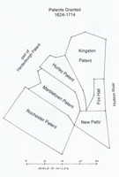
Patents. The only patent I could find for the area during the 1610-1664 was for Fox Hall, a small rectangle on the Hudson River, for which I have not been able to determine how it started nor how it passed out of existence. During the early British times, patents were granted for New-Paltz and Kingston, and later patents were granted for Hurley, Marbletown, and Rochester. Contra to the usual practice of granting huge acreage to favorites, these patents were granted to trustees who later distributed the lands to yeoman-type settlers who were determined not to become mere leasers from lords of manors.
When the British took over New York from the Dutch, the governors confirmed most of the original Dutch grants, probably to gain the allegiance of the Dutch groups. Most of the grants were first invalidated, and the owners had to show they had received the land from the Indians. This became a source of interesting income for the officials. After the American Revolution, all the grants were again invalidated, and the owners had to reapply. More interesting income, both official and unofficial, for the agents!
Rochester received a patent June 25, 1703 and became a town March 7, 1788. From it was taken part of Middletown, ( Delaware county), Neversink (Sullivan County), 1798; Wawarsing, 1806, and a part of Gardiner 1853. Millstones were once quarried in quantity. There were settlers here before the granting of the patent, for 1688 documents mention a saw mill, a "corn mill" and a church. Lake Minnewaska and Lake Mohonk adjoin the town.
Marbletown derived its title from a patent of Queen Anne, dated June 25, 1703, and was formed as a town on March 7, 1788. A part of Olive was taken off in 1823, and a part of Rosendale in 1844. The village of Marbletown had its turn as the capital of the State before Hurley, for at the burning of Kingston in 1777, the Council of Safety fled to Marbletown. One of the finest bits of scenic beauty to be found in this wild, rough town is Lake Mohonk, famous the world over.
Hurley was granted by patent October 19, 1708. It has given territory to help form New Paltz in 1809, Esopus in 1819, Olive in 1823, Rosendale in 1844 and Woodstock in 1853. It is moderately hilly, with extensive fertile flats along the Esopus Creek. The citizens of Hurley first asked for an extension of land to guarantee a supply of pasture land and forests, but the extended negotiations led to the granting of the notorious Hardenbergh Patent to Jacobis Hardenbergh and six others. Later, Robert Livingston purchased almost half of the Hardenbergh patent from its original owners.
Kingston was incorporated by patent May 19, 1667 and recognized as a town May 1, 1702. Among the towns taken from this patent are Esopus and Saugerties in 1811, Kingston City in 1827, Woodstock in 1879, leaving the town little more than a name.
New Paltz was granted by patent by Governor Andros September 29, 1677. Its bounds were enlarged in 1775, and a part of Hurley annexed February 2, 1809. A part of Esopus was taken off in 1842, a part of Rosendale in 1844, Lloyd in 1845, and a part of Gardiner in 1853.
The site was settled by French Huguenots in 1677 who named it for an earlier European refuge, the Rhenish Palatinate (German Pfalz). Six stone houses (1692-1712), part of the original settlement, are maintained by the Huguenot Historical Society.
Rosendale formed from Marbletown, New Paltz and Hurley April 26, 1844 just west of the town of Esopus stood at the head of the cement trade for a century. Rosendale cement was noted for its hardness and was the most common cement until it was supplanted by the quicker setting Portland cement. Rosendale cement is found in the Manhattan Bridge, the Croton Aqueduct system, and the pedestal of the Statue of Liberty.
Lloyd, just south of the town of Esopus, was formed from New Paltz April 15, 1845. It is well located on the Hudson, and had many fine country estates along the banks. It must have been one of the earliest settled, but when, and by whom, there is no record.
Esopus was formed from Kingston April 5, 1811. It became a favorite spot for country homes for people of means from New York and Brooklyn. Port Ewen, near the mouth of the Rondout, was founded by the Pennsylvania Coal Company in 1851 as a coal depot. Rifton, on the Wallkill, was the site of a large cotton mill. Ulster Park, north of the village of Esopus, is the center of the fruit district. Rosemount, the former home of Alton B. Parker, once a candidate for President of the US, lies near Ulster Park. West Park lies directly across the Hudson from Hyde Park; a corresponding village directly east of Hyde Park along route 9-G is named East Park.
The boundaries of the present town of Esopus were determined in 1811. The town is bounded on the north by the Rondout Creek, on the west by the Rondout Creek and Wallkill River, on the east by the Hudson River, and on the south by the town of Lloyd. The southern boundary is a straight line running approximately north-northwest beginning at the Hudson River just below the current Saint Cabrini campus. Curiously, the creek known today as "Esopus creek" now begins at the Ashokan Reservoir, curls southward towards Kingston, then turns back north and empties into the Hudson at Saugerties, never touching the town of Esopus!
The waters of the Hudson near Esopus have always been known for its high quality. Burke cites several events in the late 17th century where the governor loosened up the meeting with barrels of 'sopus ale, known for its high quality because of the water. As late as 1980, tankers delivering crude oil to Albany would pause overnight at Esopus to take on water, use it as ballast for the return trip to Saudi Arabia, and then sell it as drinking water! And until recently, the Payne estate drew its water supply directly from the Hudson.
For the remainder of this presentation, we shall refer to the town of Esopus as that marked on current maps, namely bounded on the north by Rondout Creek, on the west by the Rondout Creek and then southerly by the Wallkill River where it leads into the Rondout Creek, and on the south by the town of Lloyd. The town of Rosendale lies west of Esopus, across the Wallkill and Rondout. The Rondout Creek begins in Ellenville and wends its way generally in a northeast direction until it empties into the Hudson River; it was the route of the Delaware and Hudson Canal in the early nineteenth century. The Wallkill River originates in northwest New Jersey (skiers will recognize Vernon Valley and Great Gorge) and wends its way through Orange County and then Ulster until it merges with the Rondout just above Rifton.
Definition of towns of Esopus, Kingston and New-Paltz in the Laws of State of New York, 1813 "An ACT for dividing the Counties of this State into Towns.
Esopus And that all that part of the said county of Ulster, bounded on the east by the middle of the channel of Hudson's river, from the middle of the Ronduit creek, where it empties into Hudson's river, on the south by the north bounds of the town of New-Paltz, on the west by the east bounds of the town of Hurley, until where it crosses the Ronduit creek, and on the north by the middle of the Ronduit creek, shall be and continue a town by the name of Esopus.
Kingston And all that part of the said county of Ulster, bounded northerly by the town of Saugerties, on the east by the middle of Hudson's river, on the south by the town of Esopus, and westerly by the towns of Hurley and Woodstock, shall be and continue a town by the name of Kingston.
New-Paltz And all that part of the said county of Ulster, bounded northerly by Esopus and Hurley, easterly by the middle of Hudson's river, southerly by Marlborough, Plattekill, and Shawangunk, and westerly by the west bounds of the New-Paltz patent, continued southerly to the southwesterly corner of the same, from thence along the highest part of the precipices of steep rocks to the northwest corner of Shawangunk, shall be and continue a town by the name of New-Paltz.
We turn now to only the town of Esopus. The terrain is part of the Shawungunk mountain chain, but for the most part, Esopus is level, especially at the northern part. However, a spine of three high ridges or hills runs down the middle of the town. The northernmost part of this ridge is called Hussey Hill (elevation 1005 feet); from here the locals watched the British burn down Kingston during the Revolutionary War. The hill immediately south is called Shaupeneak Mountain (lower elevation) and directly west of the Payne lands is another hill, not tall enough to be graced with a name in most early maps. The land to the west of these hills is drained by the Wallkill and Rondout.
The land to the east is drained by the Black Creek, which originates in Plattekill at Sunset Lake, and winds twenty miles between the hills and the Hudson, emptying into the Hudson just above the Payne lands. Along the way, just below West Park, the Black Creek enters Chodikee Lake, then continues past the lake to two waterfalls near the Burroughs Nature Preserve, and finally through the Payne properties until it finally drops to the Hudson just north of the Marist Brothers' property. Black Creek derives its name from the color of the water, as it receives tannic acid from the many hemlocks and larch trees along its path; in some early deeds, it is called Beaver Creek, probably after the family of John Beaver, who settled on and just north of the Marist Brothers' property. In the winter of 1942-1943, we skated several times on Chodikee Lake, but we called it Lake Broglio, after the family who operated the restaurant now called the Hedges (or Stonehedge). Tradition held that Broglio was a major rival of John Foglia's Ship Lantern Inn, and ran a speakeasy near the lake which burned down. We found a small shed near the lake which held several jugs of what tasted like pure alcohol. Brother Joseph Cadroes considered shipping it to Poughkeepsie, where several Brothers made fine liqueurs; but it was judged too untrustworthy after so many years, and was poured out. In the 1945-1965, the Marist Brothers owned a camp called Camp Sunset, but this purchase and use had no real connection to the Marist property at the other end of Black Creek.
Despite the hills, the town of Esopus has many flat sections; there are numerous tiny lakes and swamps where the water has no clear exit path. John Burroughs built Slabsides near a swamp which he partially drained, and several deeds relating to our property refer to a tamarack (or larch tree) swamp.
The railroad leaves the Hudson just below West Park and moves westerly. The original design of the New York, West Shore and Buffalo Railway called for it to hug the shore right up to Kingston; but this would then entail a bridge or trestle over water of 4000 feet, which would also interrupt boat traffic between the Rondout and Hudson. It was relocated back about a mile, where the crossing of the Rondout is less than one fourth that length, but on the heights, so river traffic was uninterrupted. As an added benefit, the railroad then ran right through the city of Kingston. The railway was built in 1881 as a rival to the New York Central; for most of its path from Albany to Buffalo its tracks ran within sight of the New York Central. The railway went bankrupt in 1884, and was swallowed by the New York Central. The original thought of linking the ports of New Jersey to Lake Erie had considerable merit, apparent today when so much of the port trade of New York Harbor has left Manhattan for Brooklyn and especially New Jersey. The railway has been reduced to a single track, but Conrail runs about 24 freight trains daily down the line. As late as 1956, Brother Brendan Regis Ginnity used to take the West Shore passenger line from Hoboken to Haverstraw to visit his folks. There is talk of restoring passenger traffic on part of the railroad, but as of this date it is just talk.
The principal north-south road is route 9W. Around 1915, this road was straightened near the north end of the Payne property. Its original route followed the current Black Creek Road and Main Street through Esopus. The stone bridge near the southern end of Black Creek Road was designed and built by Julian Burroughs, and superintendent of the Payne estate and son of John Burroughs the famous naturalist. The Beaver family cemetery is also located along Black Creek Road.
The town of Esopus has no cities, but several hamlets. Along the river, from south to north, we can identify West Park, village of Esopus, Ulster Park, Port Ewen and Sleightsburgh, the last being on a low section of land at the intersection of the Rondout and the Hudson. On the west, from south to north, there is Dashville (home of the Perrine Bridge, one of the last remaining wooden bridges in New York State, location of falls which furnished power for several factories operated by the heirs of Archibald Russell), then Rifton (home of Central Hudson's recreation site), and closer to Kingston, Saint Remy, New Salem and Connelly.
The principal farm products of the town of Esopus are grapes and apples. The west shore has several slopes facing south and east, making them suitable for wine grapes, and even today there are several wineries along route 9W. But apples are the major product. In the first half of the 19th century, Robert Livingston Pell developed a process of preserving apples which enabled him to ship them to Europe, where they became popular. In 1942-1945, I remember spending a week picking apples. The pay for the students' apple picking was a few crates of good apples, and plenty of 'drops', which had to be peeled, cored and canned quickly. Currently apples are one of my favorite fruits, but in the 1950s I avoided them completely; my days in Esopus and Poughkeepsie had 'appled me out'.
References:
Town of Esopus Story, 3000 B.C. - 1978 A.D., Ulster County, New York, published by Town of Esopus Bicentennial Committee, 1978. (Available in Port Ewen library on 9W, Burroughs reading room; also available for purchase at nearby pharmacy).
Laws of the State of New-York revised and passed at the thirty-sixth session of the Legislature, furnished by the revisors, William P. Van Ness & John Woodworth, esquires; Albany, H. C. Southwick & Co, 1813 (donated by Constance ?? to Marist College library)
Burke, Dutch and English Colonies in America, 2 vols, 1899 (Available in Chappaqua library)
Maps and Charts of State of New York (circa 1949) (Available in Chappaqua library)
Dr. James Sullivan, editor, History of the State of New York 1523 - 1927, New York, The Lewis Historical Publishing Company, Inc. 1927, volume 2.
Marist University | Marist Archives & Special Collections | Contact Us | Acknowledgements